M 6.2 Christchurch Tue, Feb 22 2011
The city of Christchurch experienced a major earthquake centred south of the city; severe damage and casualties occurred.
The city had been comparatively lucky with both the location and timing of the earlier magnitude 7.1 Darfield (Canterbury) earthquake; the location of this one however - within 10 km of the city and at a shallow depth of 5 km - during the middle of a working day resulted in destruction, injuries and deaths.
- Magnitude: ML 6.3
- Casualties: 185 deaths
![Damage to buildings in the central city, Christchurch. [GNS Science]](http://static.geonet.org.nz/info/images/quakes/historic/3468575/2326659.jpg)
Damage to buildings in the central city, Christchurch. [GNS Science]
![Car trapped by liquefaction in Ferrymead, Christchurch. [GNS Science]](http://static.geonet.org.nz/info/images/quakes/historic/3468575/2326660.jpg)
Car trapped by liquefaction in Ferrymead, Christchurch. [GNS Science]
Aftershock detection
GeoNet staff deployed portable earthquake recorders to collect information on the rich aftershock sequence of the earthquake. Earthquake data from the portable instruments are used in conjunction with data from permanent GeoNet monitoring stations and portable instruments that had remained deployed following the M7.1 Darfield earthquake. This combined earthquake dataset is used in scientific studies of fault structures and ground motion.
In total, 6 short-period seismometers and 4 strong-motion accelerometers were placed around the outskirts of Christchurch. The short-period instruments were installed in the area of aftershocks to enable increased precision of earthquake locations and an enhanced understanding of local fault structure. The strong-motion instruments were deployed in the Port Hills to reveal ground motion differences between the hills and the plains as well as to measure ground accelerations associated with any landslides that were caused by aftershocks.
Focal Mechanisms
Focal mechanisms or fault plane solutions show the fault and direction of slip. The last figure shows focal mechanisms for the immediate aftershocks. The M 6.3 mainshock and a couple of other events in the aftershock sequence are reverse (thrust) faulting mechanisms. Also the two events furthest to the west are mainly reverse faulting and may be considered as part of the aftershock sequence to the September 2010 M 7.1 earthquake rather than the February M 6.3 earthquake. Most of the remaining mechanisms are strike-slip or mainly strike-slip solutions although the orientation of the fault plane is variable.
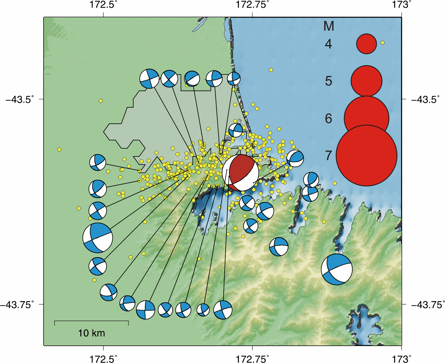
Focal mechanisms for the M6.3 quake (red) and the larger aftershocks (blue) after the first 10 days of the sequence; yellow dots are locations of the other aftershocks. Note that focal mechanisms are offset from the true location for better visibility.
Landslides and Rockfalls
![Large rock falls triggered by the earthquake, Sumner, Christchurch. [GNS Science]](http://static.geonet.org.nz/info/images/quakes/historic/3468575/2326661.jpg)
Large rock falls triggered by the earthquake, Sumner, Christchurch. [GNS Science]
Read about the GeoNet response to the landslides and rockfalls after the Christchurch earthquake:
- GNS Science Immediate Report LD8 (NZTopo50-BX24)/941-947 (6.32Mb) Report on Landslide Reconnaissance Flight on 24 February 2011 following the MW 6.3 Christchurch Earthquake of 22 February 2011
- Christchurch Earthquake Rockfall and Landslide Response (1.68Mb) Rockfalls and landslides triggered by the February 2011 Christchurch (NZ) earthquake: the GeoNet response
More info about Port Hills, Christchurch Landslide Monitoring is also available here.
Portable GPS deployment in Clifton and Redcliffs
Land above the cliffs at Clifton and Redcliffs was monitored for movement with portable GPS receivers, and a weather station was deployed to correlate any movement with weather events. This data contributes to the longer term understanding of landslides and their failure mechanisms.

Portable earthquake recorder deployment sites are shown as yellow circles (short-period instruments) and yellow squares (strong-motion instruments).
Engineering
Shaking intensity in the city was much greater for this earthquake than the September 2010 M 7.1 earthquake or any of its other aftershocks. This was due to the proximity of the epicentre to the city and its shallow depth. The highest shaking was recorded at Heathcote Valley Primary School at 220%g, with readings of 188%g at Pages Road Pumping Station and 107%g at Hulverstone Drive Pumping Station.
The available strong motion data products for Christchurch earthquake, together with plots of seismic waveforms and response spectra, are available from the GeoNet strong-motion site. Through the GeoNet API, a summary information of station peak motions for this event is also available (https://api.geonet.org.nz/intensity/strong/processed/3468575).