
Winter landslide round-up
After autumn storms, a soggy winter brought even more landslides across New Zealand.
A quiet June
June was a relatively quiet month on the landslide front, despite a few rainfall events in the North Island. Heavy rain caused slips on SH1 near Warkworth (2 June), on SH25 in Coromandel (10 June and 23 June), and on Anaura Road and Tauwhareparae Road ('Doonholm Slip') in Gisborne (25/26 June).
In Wellington, a small rockfall (about 2 cubic metres) happened on Palliser Road, Mt Victoria on 30 June. No rain was recorded on the 30th but 46 mm had fallen in the previous seven days.
July, on the other hand, being one of the wettest Julys on record, was a different story...
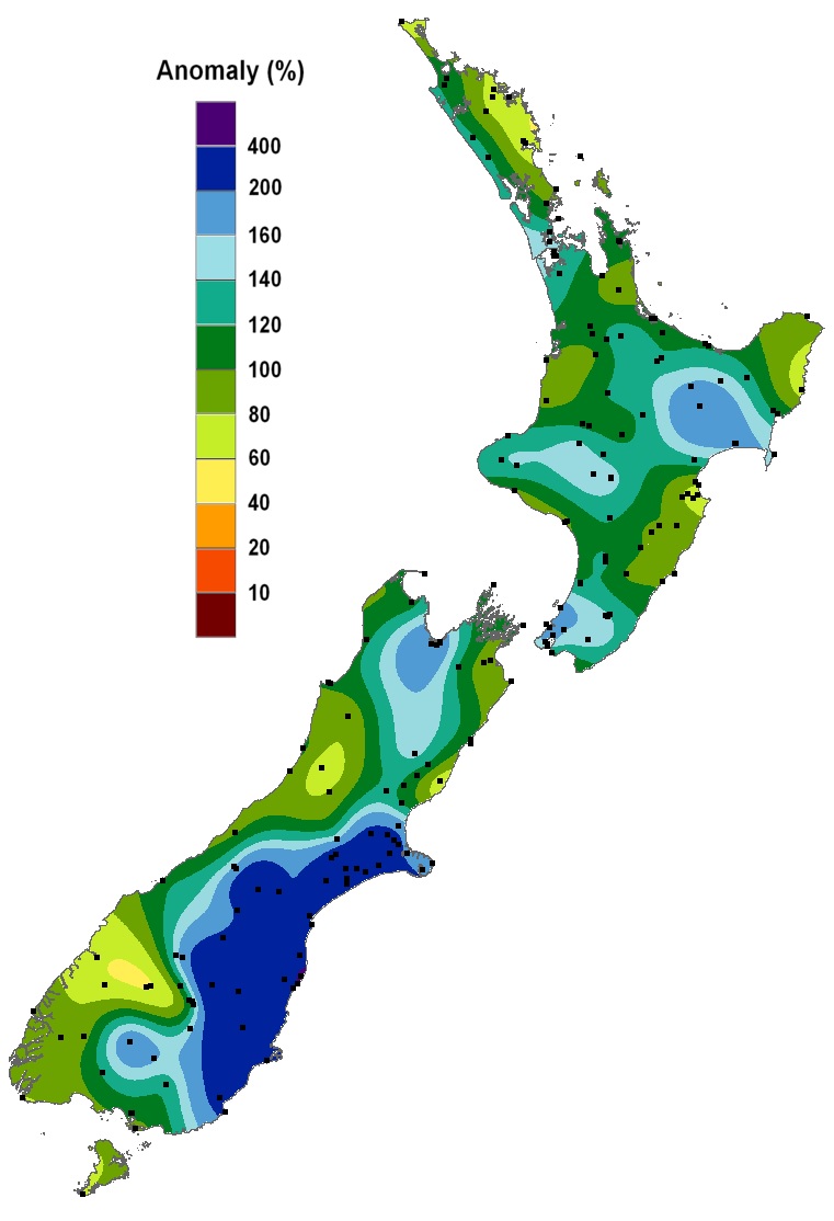
July 2017 rainfall compared to average July rainfall (NIWA)
Ngauranga Gorge debris avalanche
Rush hour traffic on Wednesday 12 July was halted by a debris avalanche that blocked five lanes of SH1 in the Ngauranga Gorge, just north of Wellington.
We initiated a GeoNet landslide response to capture information and data on the landslide. The team used a laser scanner to build a 3D model of the slip which was compared to 2013 lidar (high resolution topography) data, and estimated that between 90 and 100 cubic metres of rock fell onto the road. You can read more about our landslide response here.
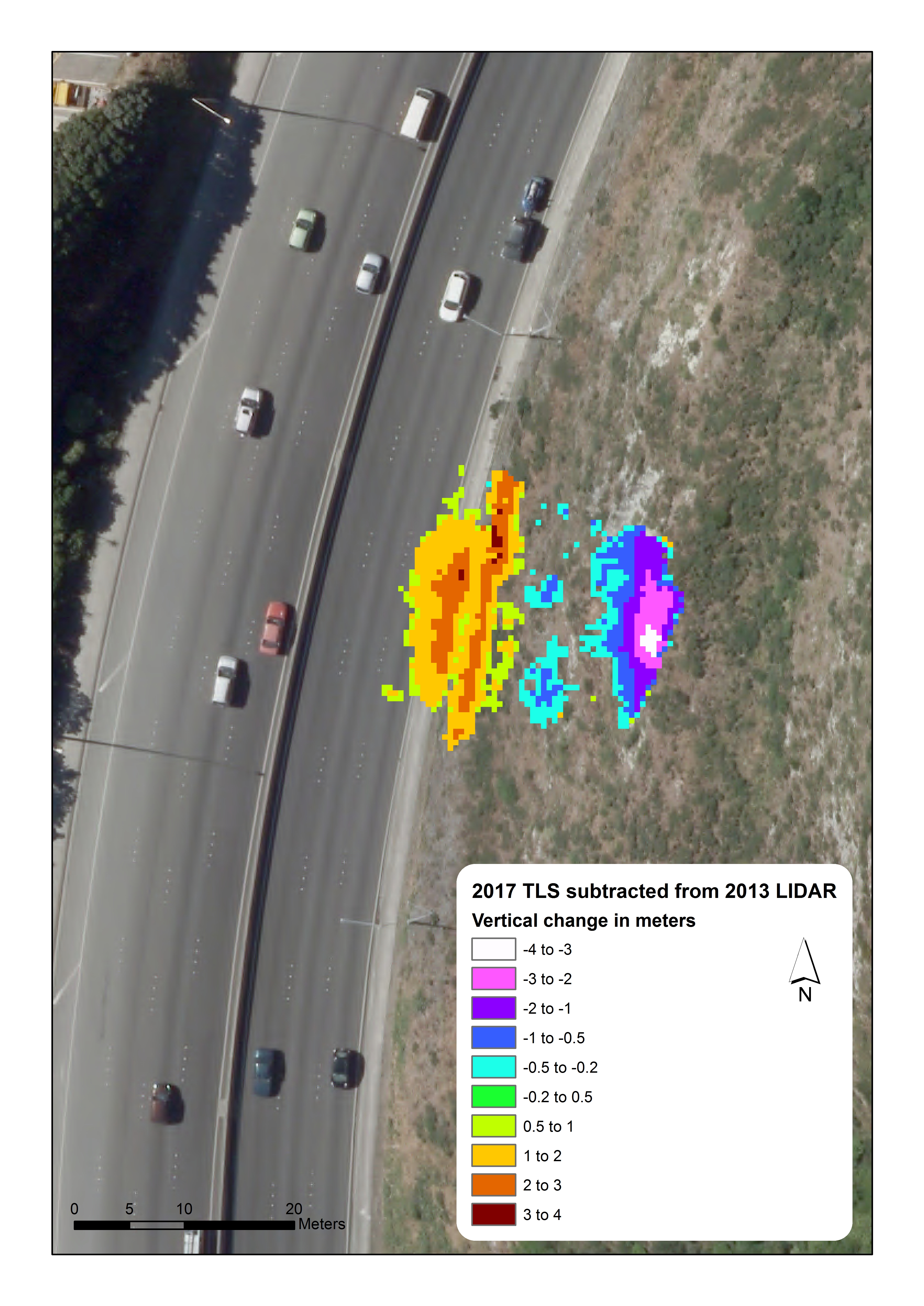
Change model for Ngauranga Gorge Debris Avalanche
14/15 July rainfall
A cold winter southerly brought snow to both islands and heavy rain triggered many landslides in Gisborne, Wairarapa and Wellington.
Several roads in the Gisborne area were blocked or reduced to one lane by landslides, including SH35 (Te Araroa to Tikitiki) and SH38 (Wairoa to Urewera National Park).
Tiniroto Bluffs near Gisborne, 14 July 2017 (photo: Gisborne District Council)
In the Wairarapa the rainfall caused more than 20 landslides and debris flows at Martinborough Station (and probably elsewhere), and high flows in the Waingawa River caused up to 20 metres of river bank erosion.
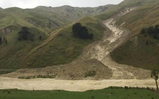
Debris flow at Martinborough Station, 14 July (photo: James Bruce)
Many roads in Wellington were blocked by landslides and rockfalls. One landslide in Melrose broke a gas line, and landslides in Kaiwharawhara buried a car and damaged an industrial building.
21-23 July storm
A week later the rain came from the other direction - the tropics. Canterbury and Otago bore the brunt of it as a low-pressure system off the east coast of the South Island whipped the rain around and straight into these regions, causing a huge mess of flooding and landslides to put it simply. Oamaru recorded its wettest day since daily rainfall records started in 1950, with 161mm of rain in 24 hours (the previous record was a 56mm on 30 July 1974).
Check out the story we wrote at the time for a summary of the landslides triggered by this event.

Debris flows on Otago Peninsula, north of Harwood, 21 July 2017 (photo: Otago CDEM)
Aside from the widespread flooding, the intense rain triggered many landslides in Canterbury and Otago, one of which killed a pair of little blue penguins at Pilots Beach on Otago Peninsula. Landslides were also recorded in the Coromandel, Gisborne, Bay of Plenty, Manawatu, Wellington and Tasman.
Ngaio Gorge landslide
Just two weeks after the Ngauranga Gorge rockfall, a landslide blocked the Ngaio Gorge road, only 3 km southwest, for two weeks.
Early on Saturday 29 July our landslide team got a call from roading contractors at Downer Group, concerned that a small landslide in the gorge that they were clearing was still moving. Our team assessed the site, including doing a drone fly-over, which found that there were cracks above and next to the area from where rock and soil had already fallen. There was still potential for more rock and soil to fall, so Police decided not to reopen the road that day.
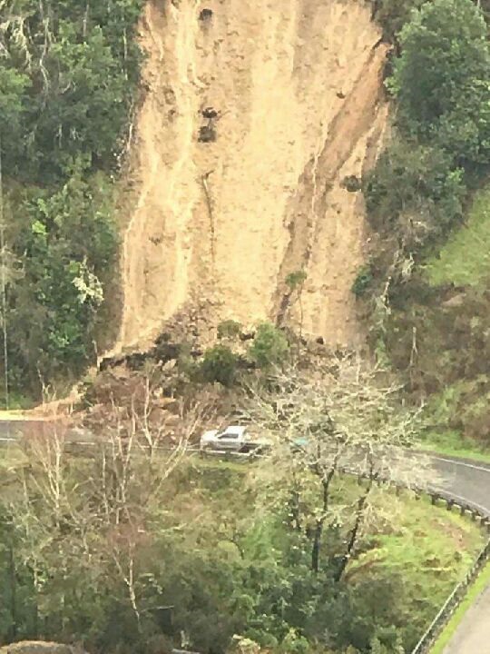
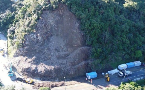
The following morning, between 7:30 and 8:00 am, a much larger volume of material fell from the slope, depositing about 1,300 cubic metres of rock and debris, including large boulders, onto both lanes of the road, blocking it completely.

Ngaio Gorge, Saturday 29 July (photo: Will Ries/GNS Science)
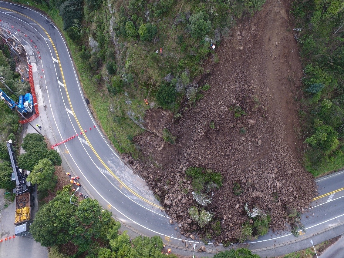
Ngaio Gorge, Sunday 30 July (photo: Will Ries/GNS Science)
Our landslide team built a detailed 3D model of the landslide using a laser scanner to determine the volume of rock involved. You can read more about our response to this landslide here.
Loose rock was sluiced from the slope by helicopter before a 20-tonne excavator was brought in to remove debris. This work was hampered by a further 40 cubic metres of rock, that's about 4 or 5 Ohakune Big Carrots, coming down on 3 August. Wellington City Council contractors then realigned the road and installed containers along the base of the slide to minimise the risk of rocks falling onto cars. The road was reopened on Monday 14 August; more rock fell from the landslide on 31 August, but fortunately the containers did their job and stopped this material from reaching the road.
Ngaio Gorge, Monday 14 August (photo: Wellington City Council)
Elsewhere in July
Rockfalls and slips closed SH25 at Ruamahanga Bay north of Thames on 2 and 3 July. Landslides closed several roads in the Gisborne area in early July, including SH2 through the Waioeka Gorge where a 4500 cubic metres of debris blocked the road for a week.
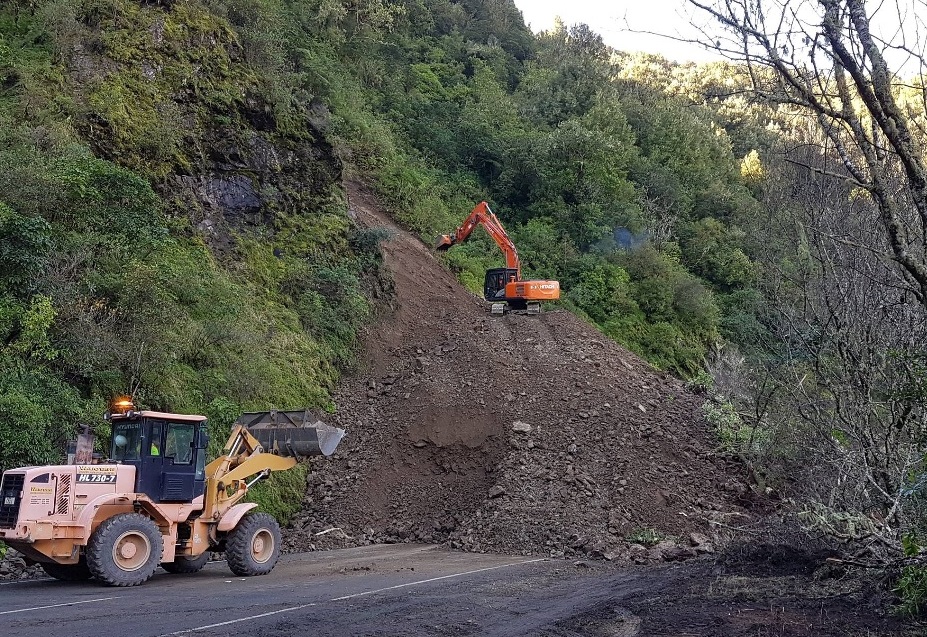
Waioeka Gorge, 7 July 2017 (photo: Tairawhiti CDEM)
Heavy rain in the Wellington region on 25 and 27 July triggered several landslides and rockfalls at Paekakariki Hill Road, Tawa, Makara, Aro Valley and Evans Bay. Roads were closed and two homes were evacuated.
Canterbury rain
On 13 August torrential rain on the Canterbury Plains and Banks Peninsula caused flooding and triggered many landslides, which closed SH75 between Christchurch and Akaroa and SH77 at Rakaia Gorge. A further landslide blocked one lane at Robinsons Bay near Akaroa on 17 August.
Mid-August heavy rain in lower North Island
Heavy rain in the lower North Island on 14/15 August triggered several landslides in the Wellington region. A large landslide in Plimmerton undermined a deck and hit two cars, shunting them across the road. A woman who was in one of the cars at the time walked away without serious injury.

Plimmerton landslide, 15 August 2017 (photo: Stuff)
On 18 August another landslide closed one lane of Wellington's Ngaio Gorge, about 200 metres down the valley from July's landslide.
Even more heavy rain in Wellington
Wellington received half its average August rainfall in one day on Thursday 31 August, triggering over 20 landslides which blocked roads throughout the city. Several houses and flats were evacuated and one car was buried.
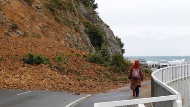
The Esplanade, Houghton Bay (photo: Ross Giblin/Stuff)

Pass of Branda, Seatoun (photo: Sarah Gunn)
Elsewhere in August
It wasn't all about Wellington in August. Heavy rain also triggered landslides which blocked SH3 at Urenui in Taranaki (2 August), Bushy Knoll Road in Gisborne (7 August), SH2 in the Waioeka Gorge between Opotiki and Gisborne (10 August), SH6 between Greymouth and Westport (18 August), and Scenic Drive in Auckland (30 August).
SH6 was affected by rockfalls in the Kawarau Gorge between Queenstown and Cromwell, and on 20 August a 10 metre section of cliff in Buckland's Beach collapsed, taking with it a back yard, a fence and trees.
Science contact: Brenda Rosser, GNS Science
GeoNet is required to regularly report on landslide events in New Zealand as part of our funding arrangements with the Earthquake Commission.