
Autumn landslide round-up
Our landslide scientists have been so busy this year that we’re only just getting autumn’s landslide round-up out, and it’s almost spring! The theme of autumn’s round-up can be summarised in three words: lots of rain.
The dominant weather patterns that kept us cool over summer also kept tropical cyclones from venturing down our way. But that weather pattern changed into autumn so while most of us got a welcome late summer, it also opened the way for Cyclones Debbie and Cook to pay us a visit.
The Tasman Tempest
Even before the cyclones arrived a weather system, nicknamed the Tasman Tempest, brought several downpours of heavy rain to parts of the country in early March. The rain was caused by a southward-moving low pressure system in the Tasman Sea, which was halted in its tracks by a high pressure system further south. The low pressure system brought with it moist tropical air which fell as three bands of heavy rain between 7 and 12 March.
The rain caused flooding and landslides in Northland, Auckland (particularly the Hauraki Gulf, including Waiheke Island, and the Hunua Ranges in the southeast) Coromandel, Waitako, Bay of Plenty, Rotorua, Gisborne and Wellington. 24 hour rainfall totals were up to 450 mm – in some places that was a 100+ year return period. SH25 was closed in the Coromandel because of slips.
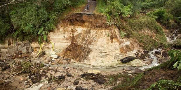
Paradise Valley Road, Rotorua, 13 March 2017 (photo: Dominion Post)
People were cut off by landslides, several families were evacuated from homes because of landslides, and landslide damaged houses. Many landslides were reported in farmland and forestry areas, and DoC facilities were damaged in the Kaueranga Valley near Thames.
In the Hunua Range near Auckland two school camps were evacuated after rainfall caused landslides and flash flooding. Hundreds of landslides tore through commercial forests and native bush in the ranges, dumping tons of sediment into water reservoirs and affecting Auckland’s water supply.
Waiheke Island received over a month’s worth of rain overnight on 8 March, triggering many landslides that cut power and blocked roads. More heavy rain on 10 March caused cliff collapses, damaged buildings and closed roads.
In the Waikato the rainfall caused a textbook rotational slump landslide on farmland near Mercer. Check out that head scarp – the ‘cliff’ created at the top of the landslide by the soil falling away below.

Landslide at Mercer, Waikato, March 2017 (photo: Chris Elbe)
The Tasman Tempest also closed SH1 south of Kaikoura because of the increased risk of rockfall. Rocks up to 1.5 metres across (bigger than a large beanbag) fell from a dozen slip faces onto the road.
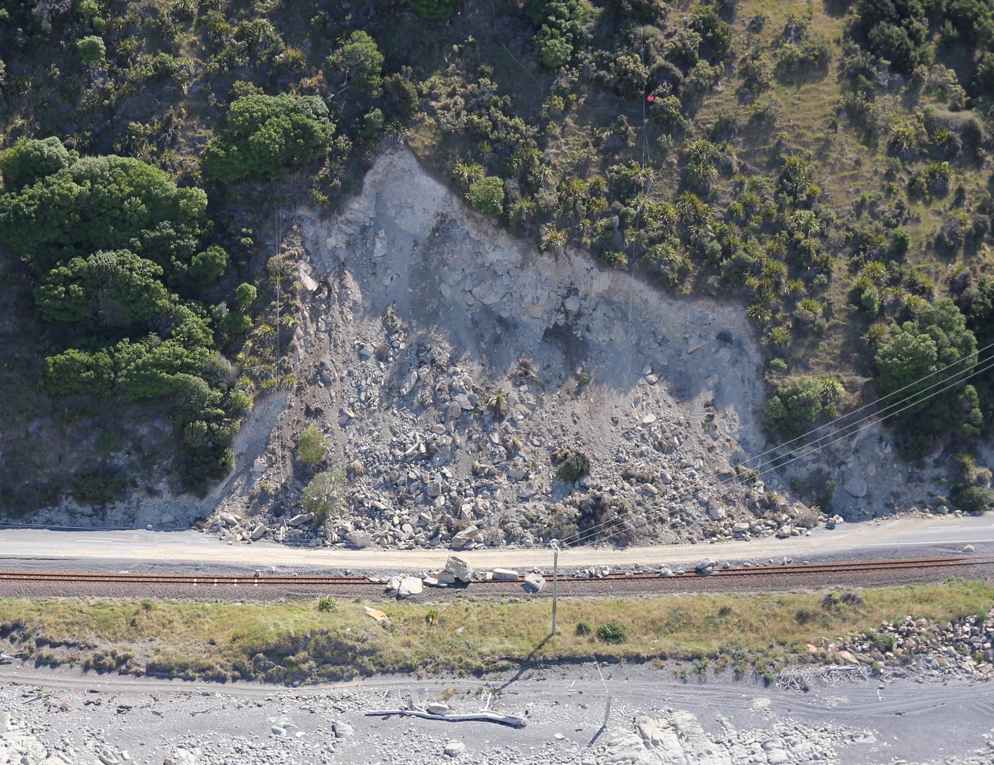
SH1 south of Kaikoura, 8 March 2017 (photo: New Zealand Transport Agency)
Floyd Pond
Not wanting to be left out of the landslide dam action, three trampers found the North Island’s one and only reported (probable) Kaikoura earthquake-formed landslide dam in March. The 300 metre long landslide, in the headwaters of the Tauherenikau River in the Tararua Range, had dammed a 100 metre long lake behind it. The condition of the vegetation on the dam – with browned leaves still attached to the dead trees – suggested the landslide had occurred several months earlier, quite possibly around the time of the earthquake and subsequent heavy rainfall.

Floyd Pond, Tararua Range, March 2017 (photo: Joe Nawalaneic)
Because the volume of the lake was not large, and it is off the beaten track, our landslide geologists considered the risk to anything downstream to be very low.
Cyclone Debbie
The remnants of Cyclone Debbie arrived in New Zealand on 4 April, bringing heavy rain to the North Island and upper South Island over the following two days. 172 mm of rainfall was recorded at Whangaparaoa, north of Auckland, from 9am on 4 April to 9am on 5 April. Whakatane in the Bay of Plenty and Whitianga in the Coromandel both recorded their wettest April day since records began (1952 and 1961 respectively) with 137 mm and 150 mm.
The rainfall triggered many landslides which blocked roads in Auckland, Coromandel, Waikato, Bay of Plenty, Gisborne, Hawke’s Bay, Taranaki, Whanganui, Manawatu, Wellington (ok, pretty much the entire North Island) and once again Kaikoura was completely cut off by landslides, some reactivated and some new. A tomo (an underground cavity) was discovered under SH1 near Tirau, which caused delays for several days while the road was stabilised.
In Auckland a mudslide hit an apartment building in Kohimarama. Four apartments were damaged, with windows and doors blown in, but there was no structural damage. Two people were initially feared missing but they were quickly accounted for. Trees, fences and gardens at the top of cliffs along Auckland’s East Coast Bays fell into the sea, and the beach between Browns Bay and Waiake Beach was closed as a precaution. Landslides in Titirangi and near the Waharau community on Auckland’s east coast blocked roads and stranded residents. In the Waikato 150 children and adults were trapped in Port Waikato overnight when a large slip blocked the road in both directions.
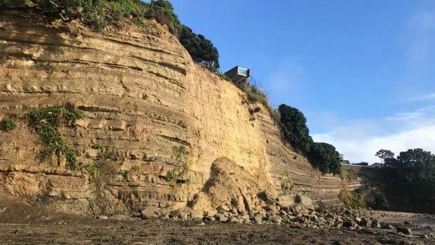
Sandstone cliffs, East Coast Bays, Auckland, 5 April 2017 (photo: Zizi Sparks/Fairfax NZ)
A landslide hit a house in Newtown, Wellington, but there was little damage to the house itself, and three houses were evacuated as a precaution in the suburb of Kingston.
Several of Kaikoura’s landslide dams overtopped during the heavy rain – you can read about the impacts in the story we ran at the time. And as if an earthquake wasn’t enough, the heavy rain picked up landslide debris and washed it down the hill and into the back of a house at Rakautara, just north of Kaikoura. Mudslides or debris flows like this can be more common for years after an earthquake as water picks up and carries away rock and soil shaken from the hills.
Cyclone Cook
Cyclone Cook arrived hot on the heels of Debbie, bringing more rain (and a dose of very strong wind) from 12-14 April. Heavy rainfall again caused landslides that blocked roads in Northland, Waikato, Coromandel, Bay of Plenty, Gisborne, Wellington, Tasman and Kaikoura.
A new landslide was triggered at Rosy Morn, south of Kaikoura, a site known for slips even before the Kaikoura earthquake. About 10,000 cubic metres of debris (think a rugby field neck-deep in rocks) came down over the road and railway.

Rosy Morn landslide, SH1 south of Kaikoura, April 2017 (photo: New Zealand Transport Agency)
May rain
On 12 May a low pressure system brought more heavy rain to parts of the North Island – 105 mm in 11 hours was recorded to the west of Rotorua. In the Bay of Plenty rain caused landslides and washouts that closed SH2 in the Waimana Gorge, SH35 at Motu Bluffs between Opotiki and Te Kaha, and some local roads. Landslides also closed Paekakariki Hill Road near Wellington.
Other, smaller rainfall events during autumn caused landslides that blocked SH3 in Taranaki, SH25 in Coromandel, the Rimutaka Hill Road (where two cars were hit by the landslide, but no one was injured), and the Manawatu Gorge (which remains closed).
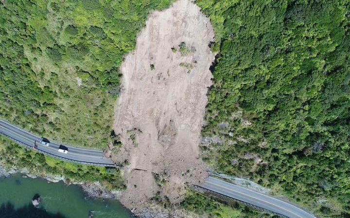
Manawatu Gorge, April 2017 (photo: New Zealand Transport Agency)
We didn’t launch GeoNet landslide rapid responses for the Tasman Tempest, Cyclone Debbie or Cyclone Cook, because landsliding occurred over such a wide area and it would have been difficult to get around with the flooding and landslides affecting many roads. Our landslide team did monitor the events closely though and an extensive record of landslides triggered by the events were made.
The rain hasn’t let up over the winter and we’ll have more to report in our winter round-up.
Science contact: Brenda Rosser, GNS Science.
GeoNet is required to regularly report on landslide events in New Zealand as part of our funding arrangement with the Earthquake Commission.