
Updated: Gisborne and Hawke's Bay slow-slip event now extends to include Kapiti and Manawatu regions following M7.8 Kaikoura Quake
Update 6pm, Saturday 26th November:
The slow-slip event detected earlier this week of the east coast now has company. More slow-slip movement on the Hikurangi subduction zone (where the Pacific and Australian plates meet) has now been detected by GeoNet and PositioNZ cGPS sites in the Kapiti and Manawatu regions. We have recorded multiple slow-slip events in all of these regions previously (since they were first discovered in early 2002), and sometimes one region slips after another, however we have never detected slow-slip simultaneously in multiple regions. We have also never monitored slow-slip following a central New Zealand earthquake as big as the M7.8, so this could be typical bahaviour in the aftermath of such a large earthquake. We are continuing to monitor the event closely as it unfolds, and we will provide regular updates. The Kapiti-Manawatu slow-slip event has involved movement across the Hikurangi subduction zone plate boundary of between 5-7cm, equivalent to a magnitude 6.8 earthquake in the last two weeks. The Gisborne-Hawke’s Bay event has involved slip across the plate boundary up to about 15cm, equivalent to a magnitude 7.2 earthquake. The cGPS data suggest that the Gisborne-Hawkes Bay slow slip event appears to be tapering off in the last day or two.
GPS stations have detected a slow-slip event under the Hawke’s Bay and Gisborne regions in the days following the Kaikoura M7.8 Earthquake.
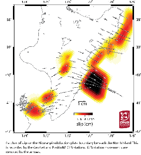
Areas of slip - updated Saturday 26 November
What is a slow slip event and how are they detected?
GeoNet, in partnership with LINZ run a network of GPS stations around the country that are able to detect land movement as little as a few millimeters resulting from silent earthquakes. These silent earthquakes or slow-slip events are undetectable by both humans and GeoNet's seismographs. They can move faults the equivalent of magnitude 6+ earthquakes over a period of weeks to months, without any detectable shaking.
These slow-slip events occur below the earth’s surface where the Pacific Plate meets the Australian Plate, along the Hikurangi Subduction Zone. More info: on the GNS webpage and GeoNet Q&A about slow-slip events.
The slow-slip event following the Kaikoura Earthquake
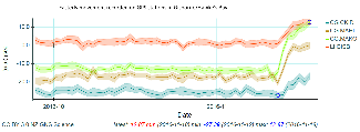
The ongoing slow-slip event off the North Island’s east coast has moved some GPS stations up to 2-3 centimetres. This movement is similar to what has been observed in previous East Coast slow-slip events over the last 15 years, so is not necessarily abnormal. We see events in this area usually every 1-2 years. We have also observed other slow-slip events happening in response to large earthquakes. The last slow-slip event offshore of Gisborne followed the Te Araroa earthquake in September 2016. A slow-slip event also occurred following the 2007 M6.7 Gisborne earthquake.
This slow-slip event is particularly interesting as it appears to involve slip along the plate boundary from Hawke's Bay up to East Cape at the same time. Normally we see slow-slip events in these regions but they are separated in time or happen one after the other, as was the case after the Te Araroa Earthquake. It is possible that passing seismic waves from the M7.8 earthquake caused stress changes that triggered the slow slip event. GNS Science and GeoNet and scientists are keeping a close eye on the event as it evolves.
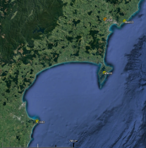
Map of GPS stations plotted in the graph to the right
Modelled areas of movement beneath the seafloor. The model is derived from movement of land recorded on GPS instruments.
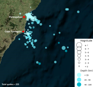
Porangahau Earthquakes
Update: Saturday 26 November As of Saturday 26th November, 225 earthquakes have been recorded in the Porangahau region since the Kaikoura Earthquake. Most of the earthquakes have been smaller than magnitude 3.
Earthquakes recorded in the Porangahau area since 14th November
A magnitude 5.5 earthquake struck on 22nd November , 65 km south-east of Porangahau.
This is in the same area as the slow-slip event detected offshore of Hawke's Bay and Gisborne (see below).
Clusters of earthquakes, generally less than magnitude 5, have occurred multiple times in this area offshore of Porangahau, including 2001, 2006, and 2011. During the 2006 and 2011 cluster we also observed a slow-slip event in the same area (GeoNet started installing GPS instruments in the Hawke's Bay in 2002 so we don't know if the 2001 cluster was also associated with slow-slip event, though we suspect it might be). Previous earthquake clusters in this area have gone on for weeks.
What does this mean?
Unfortunately, no one can give a definitive answer to this question as the precise linkage between slow-slip events and standard earthquakes is not well understood - this is still an area of active research. Like lots of scientific discoveries, these slow-slip events were stumbled upon while investigating something else entirely. They were first discovered in North America a few decades ago, and only discovered in New Zealand in the early 2000s when GeoNet and LINZ began installing GPS stations around the North Island.
Large earthquakes can happen any time in New Zealand, so it's essential to be prepared for them. Check out Civil Defence for advice on how to be prepared.
As always, we will update this story as the event evolves.
Contact scientist: Laura Wallace l.wallace@gns.cri.nz