GeoNet captures images using cameras to observe changes at a particular site. This surveillance programme is currently used for volcano monitoring, but in the past was also used to observe the Christchurch rebuild.
GeoNet's volcano camera images are an important part of the surveillance programme as any changes to a volcano can be observed and compared over time. Our cameras typically produce an image every 10 minutes, though the frequency of image capture can vary from camera to camera depending on the communications bandwidth to the site. During a volcanic event we may change the frequency of capture.
To view the lastest volcano images on our website please go to the volcano camera page.
Images are accessed differently depending on if they are the latest images or from the archive.
The latest images are available via a simple URL request, which returns either an image or a GeoJSON file. You can request data by all images, specific volcano or specific camera. You can also specify the image size.
These images are updated every time a new photograph arrives, typically every 10 minutes. When using these images beware of client-side caching to ensure that the latest image is displayed
Examples:
Camera_id and volcano_id can be found in the table below, or on the network map.
Single image request
By default the large image is returned to specify size prefix using t- for thumbnail, m- for medium.
The all GeoJSON is made up of an array of individual volcanoes, described as a feature collection of cameras at points
Individual volcano GeoJSON feeds can be fetched using the appropriate volcano_id
Individual camera GeoJSON feed containing the most recent timestamped images and thumbs is also available by using the camera_id
Available Volcano Cameras and Codes for Latest Images
| Volcanic Centre | volcano_id | Camera View | camera_id |
|---|---|---|---|
| Ruapehu | ruapehu | from North | ruapehunorth |
| from South | ruapehusouth | ||
| Ruapehu or Ngauruhoe | either | Ruapehu and Ngauruhoe | ruapehungauruhoe |
| Ngauruhoe | ngauruhoe | Ngauruhoe | ngauruhoe |
| Tongariro | tongariro | Tongariro | tongariro |
| Te Maari Crater | tongarirotemaaricrater | ||
| White Island | whiteisland | from crater floor | whiteislandcraterfloor |
| from north rim | whiteislandcraterrim | ||
| from Whakatane | whakatane | ||
| Kermadec Islands | kermadecislands | Raoul Island | raoulisland |
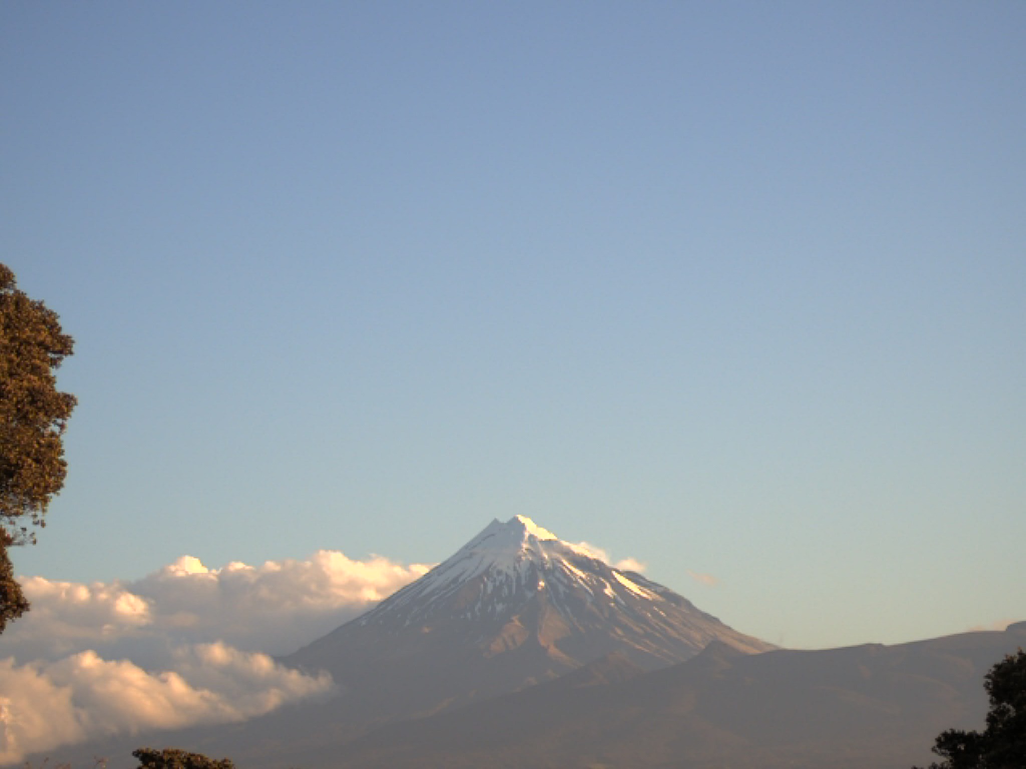
| Taranaki (Egmont) | taranakiegmont | Taranaki | taranaki |
An archive of volcano camera images is available via the following:
In December 2020, we made changes to camera site codes used in the image archive and we introduced view codes. A four-letter site code is used to reflect the location where a camera is situated. A two-digit numeric view code is used to track what a camera looks at, and any substantial and intentional changes to that view over time. At the same time as the site and view code changes were introduced, we started to use our cloud-based image archive to provide data for the Data site, which resulted in some changes to image filenames.
Camera and View Codes for Archive Images - Cameras and Views in Current Use
| New Camera Code | Camera Location | View Code | Camera View | Start Date | Old Camera Code |
|---|---|---|---|---|---|
| WHOH | Whakatane Observatory Hill | 01 | White Island | 2006-02-24T14:00:00Z | WHWI |
| WICF | White Island Crater Floor | 01 | White Island Main Crater | 2009-10-28T00:45:02Z | W, CVWF |
| WINR | White Island North Rim | 01 | White Island Main Crater | 2006-03-17T15:30:00Z | WINR |
| WIWR | White Island West Rim | 01 | White Island Active Crater | 2013-12-10T00:00:00Z | WIWR |
| DISC | Discovery Lodge | 01 | Ruapehu | 2020-07-28T02:20:00Z | R |
| DISC | Discovery Lodge | 02 | Ngauruhoe | 2020-07-28T23:40:00Z | N |
| KMTP | Kaimanawa Tai Ping | 01 | Ruapehu and Ngauruhoe | 2009-03-03T02:00:00Z | K, CVTP |
| MTSR | Mangateitei South Ruapehu | 01 | Ruapehu | 2011-09-08T00:10:00Z | MTSR |
| KAKA | Kakaramea | 02 | Tongariro | 2017-03-03T04:50:03Z | P |
| TOKR | Tongariro Karewarewa | 01 | Te Maari, Tongariro | 2012-08-29T02:00:00Z | TOTM |
| TEMO | Taranaki Emergency Management Office | 02 | Taranaki | 2012-04-03T00:15:00Z | T |
| RIMK | Raoul Island Moumoukai | 01 | Green Lake, Raoul Island | 2009-05-18T00:00:02Z | RIMM |
Camera and View Codes for Archive Images - Cameras and Views No Longer in Use
| New Camera Code | Camera Location | View Code | Camera View | Start Date | End Date | Old Camera Code |
|---|---|---|---|---|---|---|
| WHHB | Whakatane Harbour | 01 | White Island | 2001-05-21T13:00:10Z | 2007-04-13T00:00:00Z | A |
| WIFW | White Island Factory Wall | 01 | White Island Main Crater | 2001-10-12T12:00:00Z | 2009-07-20T00:00:05Z | W |
| WIFC | White Island Factory | 01 | White Island Main Crater | 2009-07-20T01:00:05Z | 2009-10-27T21:00:05Z | W |
| MNTA | Mountain Air | 01 | Ruapehu | 2000-11-14T13:00:10Z | 2020-07-27T21:20:00Z | R |
| MNTA | Mountain Air | 02 | Ngauruhoe | 2002-04-09T13:00:10Z | 2020-07-27T21:20:00Z | N |
| KAKA | Kakaramea | 01 | Tongariro | 2011-09-05T00:01:00Z | 2017-03-03T04:40:03Z | P |
| PIHA | Pihanga | 01 | Tongariro | 2015-05-28T00:01:00Z | 2019-03-04T20:30:00Z | TOPI |
| TEMO | Taranaki Emergency Management Office | 01 | Taranaki | 2002-09-18T13:00:10Z | 2012-04-02T22:45:00Z | T |
Examples of Image Filenames on the Data Site
To specify an image of Taranaki from the camera at Taranaki Emergency Management Office taken at 0600 UTC on 22 October 2020.
The site code for Taranaki Emergency Management Office is TEMO. For 22 October 2020, the view code for TEMO is 02.
The Data archive uses the day of the year (Julian day) to specify the date. For 22 October 2020, the day of the year is 296. The day of the year can be determined for any date using readily available online tools.
The image required is therefore: https://data.geonet.org.nz/camera/volcano/images/2020/TEMO/TEMO.02/2020.296/2020.296.0600.00.TEMO.02.jpg or s3://geonet-open-data/camera/volcano/images/2020/TEMO/TEMO.02/2020.296/2020.296.0600.00.TEMO.02.jpg