National Geohazards Monitoring Centre (NGMC)
Te Puna Mōrearea i te Rū
A collaboration between Science and Operations
The National Geohazards Monitoring Centre / Te Puna Mōrearea i te Rū (NGMC) provides around-the-clock monitoring of natural geohazards in Aotearoa New Zealand – earthquakes, landslides, tsunami, volcanoes.
Powered by Science
The NGMC receives live feeds from monitoring equipment located all around Aotearoa New Zealand, provided via the GeoNet system, and data from international stations.
Earthquakes are monitored using a nationwide network of more than 500 seismic and strong motion sensors.
Landslides are forecast based on recent earthquake shaking measured by GeoNet sensors or on forecast rainfall. Reported landslides are collated, including observations from the public.
Tsunami are detected via the same nationwide network used to detect earthquakes, some of which have the potential to generate tsunami, deep ocean tsunami sensors offshore and tsunami gauges located close to New Zealand's coast to monitor waves as they reach New Zealand. We also receive alerts from international organizations such as the Pacific Tsunami Warning Center, who incorporate data from our sensors in order to refine their calculations.
Volcanoes are monitored using seismic signals recorded by regional networks of seismic sensors, ground deformation measurements, gas and water chemistry, and visual observation through cameras or fieldwork.
The NGMC and each of the perils (earthquake, landslide, tsunami, volcano) are supported by a wide range of research from scientists at GNS and collaborators, as well as a communications team who help get information out to the public and stakeholders.
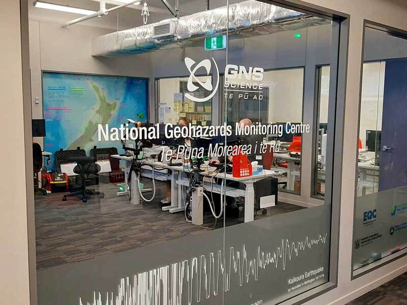
The National Geohazard Monitoring Centre / Te Puna Mōrearea i te Rū (NGMC) in Avalon at GNS

Geohazard analysts in the National Geohazard Monitoring Centre
Monitoring the Data
A team of geohazards analysts is on site 24/7 monitoring the incoming GeoNet data using specialised software. They are able to rapidly assess the data and escalate quickly when further expertise is needed to assess the threat to New Zealand. When this happens, the NGMC works with science experts to provide timely intelligence to decision-makers at National Emergency Management Agency (NEMA).
The first point of escalation for the NGMC is on-call duty officers who are GNS scientists, and, depending on the threat, panels of science experts are also convened to advise on tsunami, landslide, volcano, and earthquake events. The work the NGMC does to support NEMA and GNS Science in their response to geohazards events is key, and with a significant event, every second counts – meaning the work of the NGMC could help save lives.
Support for the centre
The NGMC opened in December 2018 and is operated by GNS Science in Lower Hutt.
It is built upon decades of work that GNS and the GeoNet programme have done with Natural Hazards Commission Toka Tū Ake and Toitū Te Whenua Land Information New Zealand. Improvements to the centre are constantly being driven by the leading science being done at GNS Science and with collaborators around Aotearoa and internationally, and it has proven to be a key part of our response system.
The centre is funded through the Ministry of Business Innovation and Employment’s Strategic Science Investment Fund and is also supported by the National Emergency Management Agency.
Read More
News release – National Geohazards Monitoring Centre opens at GNS Science, December 2018
News story – GNS has opened the National Geohazards Monitoring Centre – powered by GeoNet