Earthquake How
Computers do the ceaseless job of monitoring seismic data looking for possible earthquakes. Once one has been initially detected, the location and magnitude become refined over a number of minutes as more data from further stations arrives. For the bigger quakes, our 24/7 GeoHazards Analysts work in near-real-time with the data to verify automatic locations and magnitudes before coming back minutes later to produce their own refined manual versions of the earthquake origin and magnitude. For smaller quakes the GeoHazard Analysts still produce verified and refined solutions, just with less time pressure!
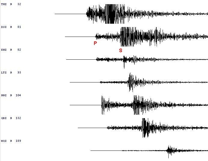
Seismic traces showing P and S arrivals.
To make rapid locations of earthquakes GeoNet operates a country-wide network of seismic stations that transmit their data to central data centres (and the cloud) where it is then analysed by automated processes. Once an earthquake is detected and an automatic location and magnitude is determined for it, its information is released onto the Quakes part of the website.
The seismic stations operated by GeoNet consist of a seismometer and a digitiser. A seismometer is a sensitive instrument that generates a small electrical current in response to ground shaking. The electrical current is digitised and transmitted continuously in real time and forms the raw data used to detect and analyse earthquakes.
The seismic stations are supplemented by a network of strong motion sensors, which are invaluable for providing records of the strong shaking produced by large or nearby earthquakes. Compared to seismometers, these sensors are very insensitive and can record up to 4 g of ground motion without clipping - something a seismometer could never dream of!
The computer processes look for ground shaking that is distinct from the normal background activity (such as that caused by weather and human activity) and is most likely to have been caused by an earthquake. These occurrences are called detections. Our automatic earthquake detection system tries to group detections in space and time. Once we have detections from at least ten stations which could sensibly be from an earthquake, we declare a seismic event.
The detections are further analysed for P (primary) and S (secondary) wave arrivals from the earthquake, and the times of these arrivals are inverted against seismic velocity models for the earth to yield the best location for the event.
The magnitude of the earthquake is determined at a station by measuring the maximum amplitude of the seismic signals, and relating them to the distance of the station from the event, together with the characteristics of the seismometer and seismograph. The magnitudes from all available stations are then averaged to give an overall value for the event.
The system also provides locally recorded data from global earthquakes to the International Seismological Centre in the United Kingdom, and preliminary earthquake information to the National Earthquake Information Center, a branch of the United States Geological Survey who locate major earthquakes worldwide. The waveform data and GeoNet located hypocentres are freely available to the worldwide community of researchers through FDSN.