The https://data.geonet.org.nz service has been updated, we hope you enjoy the new Data API. For a detailed overview of new features and breaking changes please refer to the the GeoNet help page. Any queries please contact us here or via email.
GeoNet captures images using cameras to observe changes at a particular site. This monitoring programme is currently only used for volcanoes, but in the past was also used to observe the Christchurch rebuild.
Three cameras operated in central Christchurch viewing the rebuild after the 2011 earthquake. The cameras were established in November 2011 and removed in February 2019. The images from the cameras are available from our archive.
GeoNet's volcano camera images are an important part of the monitoring programme as changes at a volcano can be observed and compared over time. Our cameras produce an image every 10 minutes. They also take an image every second which is stored on a memory card in the camera and retrieved only if required. Please contact us at info@geonet.org.nz to enquire about 1-second video imagery. The remainder of this page discusses the 10-minute images.
To view the lastest volcano images on our website please go to the volcano camera page.
Latest images and metadata are available for volcano cameras via a simple URL request. You can also specify the image size you want to receive. These images are updated every time a new photograph arrives, typically every 10 minutes. Images have a name and date-time label added. When using the URL to access an image through your web browser, make sure your browser does not cache the image file and check that the latest image is displayed.
Metadata on latest images are available as a GeoJSON file. You can request data from all volcanoes, a specific volcano or a specific camera.
Examples:
Camera_id and volcano_id can be found in the table below, or on the camera map.
Single image request
By default, a large-size image is returned. To specify image size, use a m- or t- prefix for medium-size images or thumbnail-size images, respectively.
The size of the large, medium, and thumbnail images is illustrated in a data blog The Basics of Working with GeoNet’s Webcam Images.
Metadata request
The all GeoJSON feed consists of an array of individual volcanoes, described as a feature collection of cameras at points
Individual volcano GeoJSON feeds can be fetched using the appropriate volcano_id
Individual camera GeoJSON feeds containing links to the most recent timestamped images and thumbnails is also available by using the camera_id
Available Volcano Cameras and IDs for Latest Images
| Volcano | volcano_id | Camera View (Label) | camera_id |
|---|---|---|---|
| Kermadec Islands | kermadecislands | Raoul Island | raoulisland |
| Ngauruhoe | ngauruhoe | Ngauruhoe from West | ngauruhoe |
| Ruapehu | ruapehu | Ruapehu from North | ruapehunorth |
| Ruapehu from South | ruapehusouth | ||
| Ruapehu from East | ruapehueast | ||
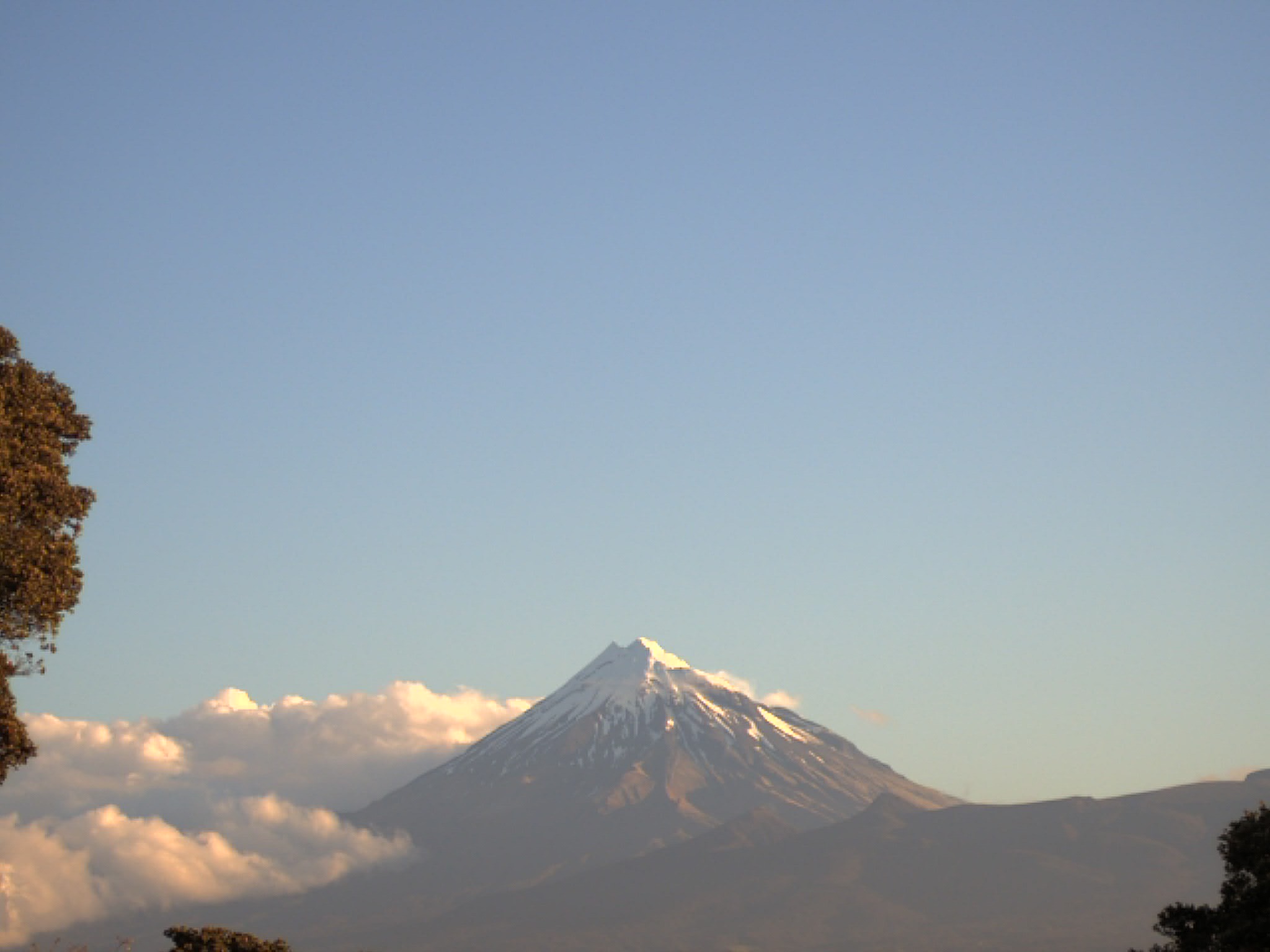
| Taranaki Maunga | taranakiegmont | Taranaki Maunga from New Plymouth | taranaki |
| Tongariro | tongariro | Tongariro from North | tongariro |
| Te Maari Crater | tongarirotemaaricrater | ||
| Ngauruhoe or Tongariro | either | Ngauruhoe and Tongariro from East | ngauruhoetongariro |
| Whakaari/White Island | whiteisland | Whakaari/White Island from Te Kaha | tekaha |
| Whakaari/White Island from Whakatāne | whakatane |
An archive of all camera images is available via:
The archive contains Christchurch rebuild images in a “building” folder and volcano monitoring images in a “volcano” folder.
How camera views and images in the archive are specified differs from the latest images. In the archive, a four-letter camera code is used to specify the location of a camera, and a two-digit numeric view code is used to track what a camera looks at. If a view has substantially (and intentionally) changed, the numeric view code will also change. Images in the archive use UTC as a time base.
This table shows some cameras that no longer operate so are not shown in the Latest Images section of this page, but there are still images from those cameras available in our archive. Details of when each camera and view code were valid are available from a file in our Delta GitHub repository.
| Camera Code | Camera Location | View Code | Camera View |
|---|---|---|---|
| CHTB | Christchurch Telecom Building | 01 | Christchurch looking East |
| CHTB | Christchurch Telecom Building | 02 | Christchurch looking North East |
| CHTB | Christchurch Telecom Building | 03 | Christchurch looking North West |
| DISC | Discovery Lodge | 01 | Ruapehu from North |
| DISC | Discovery Lodge | 02 | Ngauruhoe from West |
| KAKA | Kakaramea | 01 | Tongariro from North |
| KMTP | Kaimanawa Tai Ping | 01 | Ruapehu & Ngauruhoe from East |
| KMTP | Kaimanawa Tai Ping | 02 | Ruapehu from East |
| KMTP | Kaimanawa Tai Ping | 03 | Ngauruhoe & Tongariro from South East |
| MNTA | Mountain Air | 01 | Ruapehu from North |
| MNTA | Mountain Air | 02 | Ngauruhoe from West |
| MNTA | Mountain Air | 03 | Ngauruhoe from West |
| MTSR | Mangateitei South Ruapehu | 01 | Ruapehu from South |
| PIHA | Pihanga | 01 | Tongariro from North East |
| RIMK | Raoul Island Moumoukai | 01 | Raoul Island |
| TEMO | Taranaki Emergency Management Office | 01 | Taranaki Maunga from New Plymouth |
| TEMO | Taranaki Emergency Management Office | 02 | Taranaki Maunga from New Plymouth |
| TKAH | Te Kaha | 01 | Whakaari/White Island from Te Kaha |
| TOKR | Tongariro Karewarewa | 01 | Tongariro Te Maari Crater |
| WHHB | Whakatane Harbour | 01 | Whakaari/White Island from Whakatāne |
| WHOH | Whakatane Observatory Hill | 01 | Whakaari/White Island from Whakatāne |
| WHOH | Whakatane Observatory Hill | 02 | Whakaari/White Island from Whakatāne |
| WICF | White Island Crater Floor | 01 | Whakaari/White Island Crater Floor |
| WIFC | White Island Factory | 01 | Whakaari/White Island Crater Floor |
| WIFW | White Island Factory Wall | 01 | Whakaari/White Island Crater Floor |
| WINR | White Island North Rim | 01 | Whakaari/White Island Crater from North Rim |
| WINR | White Island North Rim | 02 | Whakaari/White Island Crater from North Rim |
| WIWR | White Island West Rim | 01 | Whakaari/White Island Crater from West Rim |
You can view the latest camera network information on our Sensor Map page. That page is updated automatically when we make changes to our camera network metadata.
The archive contains the original images retrieved from cameras. These differ in two ways from the latest images available via the URL request method.
The size of the original images is illustrated in a data blog The Basics of Working with GeoNet’s Webcam Images.
To request an image of Taranaki Maunga from the camera at Taranaki Emergency Management Office taken at 0600 UTC on 22 October 2020.
For the same Taranaki Maunga image, the required image URL is:
s3://geonet-open-data/camera/volcano/images/2020/TEMO/TEMO.02/2020.296/2020.296.0600.00.TEMO.02.jpg.
You can find more information about retrieving data from AWS Open Data on our AWS Open Data web page and in an AWS Open Data blog.
If you use our webcam images please cite us appropriately.