
Sliding Lands and New Knowledge Emerging
Updated: Mon Jul 17 2017 11:15 AM
Even after three northbound lanes were reopened, rush hour traffic on Tuesday evening ground to a crawl through the Ngauranga Gorge when a debris avalanche blocked 5 lanes of this busy stretch of State Highway 1, just north of Wellington.
Many of you will have seen the video footage captured by a fearless member of public, which shows the block of rock and soil breaking away from the slope overhanging the Ngauranga Gorge and hurtling down the hillside at about 1.8 m/second. Our very own William Reis captured the following image of the aftermath.
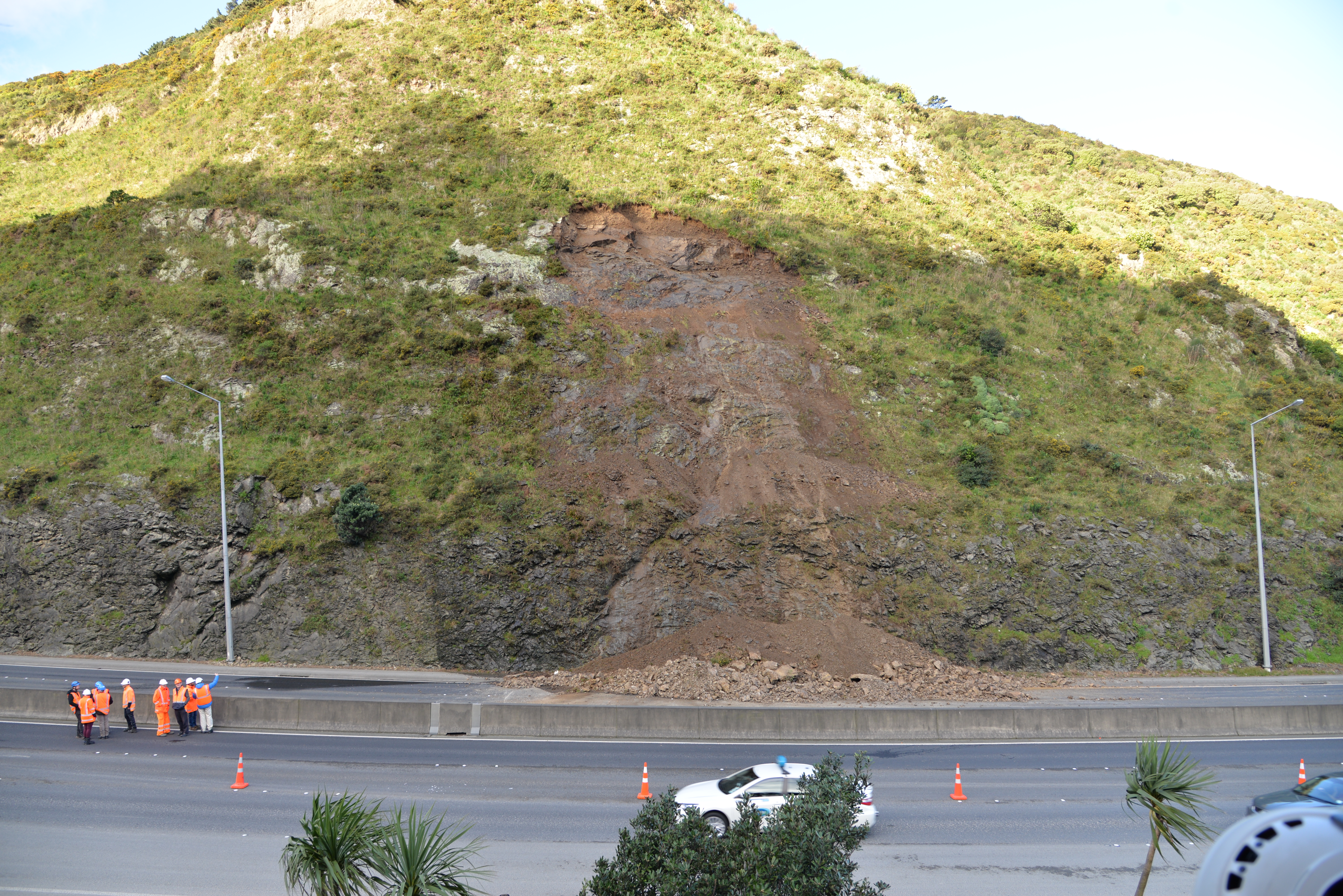
Photo of the Ngauranga Gorge landslide (Photo W. Ries, GNS Science).
Our GeoNet landslide response team has now processed the terrestrial laser scan (fancy techie equipment) data from the survey they carried out on Tuesday. By 'differencing' or comparing the slope map made from this survey with the slope map made from a previous LIDAR (remote sensing) survey in 2013 (commissioned by Wellington City Council - a big shout out is in order here), they estimate that between 90 and 100 m3 of debris rocketed down the hill, as shown by the following image.
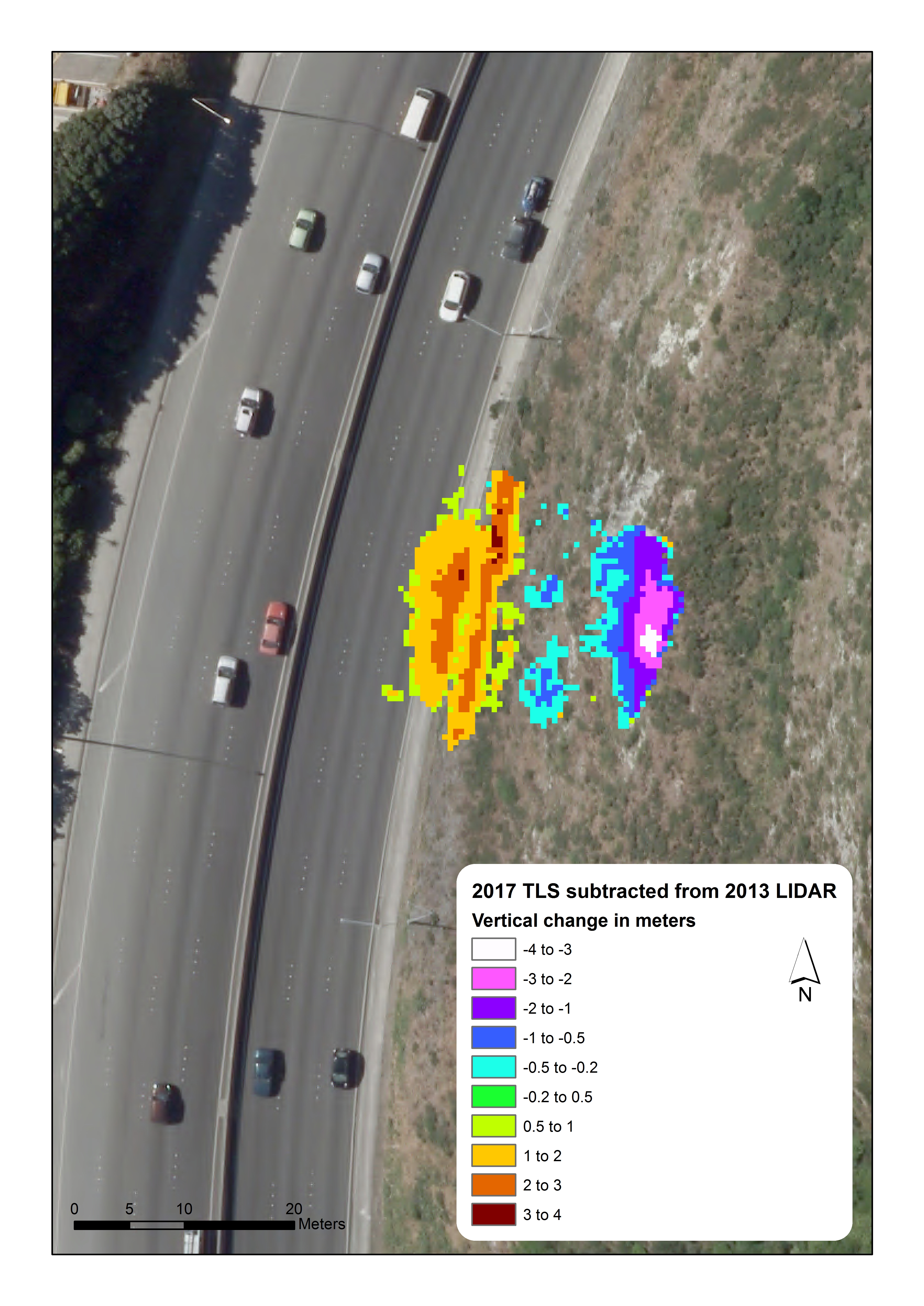
Change model for Ngauranga Gorge Debris Avalanche
The main body of debris travelled about 28 to 30 m from the top of the landslide downslope to where the slip came to rest, but boulders and “fly rock” made it onto the north bound lanes, a distance of about 50 m from the top of the landslide.
Our engineering geologist Dr Chris Massey said that landslides do not always need a ‘trigger’, such as heavy rain or an earthquake to occur, and you can read more on this here
Tuesday's landslide, however, involved the partial failure of a slope that had been modified by cutting for construction of State Highway 1 in the 1950s.
So what does our technical analysis mean?
Reading through comments on media and social media streams, some followers question why technical analysis is relevant because landslides are 'kind-of common sense'. But actually, landslides are really complex depending on location, gradient and base geology.
Our scientists have used the difference model mentioned above to “back analyse” the landslide using the RAMMS software package developed by the Snow and Avalanche Research Institute in Switzerland. One output from their model simulations of the Ngauranga Gorge slip is shown below.
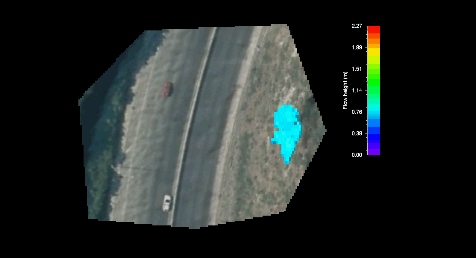
Numerical simulation (movie) of the Ngauranga Gorge landslide using the RAMMS software.
The purpose of back analysing landslides is to 'train' our models so we can use them in other locations and situations. Such models help us to better predict how far landslide debris might go down slopes and allow us to understand potential impacts across Wellington and other regions of New Zealand, by identifying what infrastructure or homes are at risk.
This is particularly relevant because the Ngauranga Gorge slip is the third high-profile landslide that has occurred on modified slopes in Wellington. The others are in fill slopes that occurred in the suburb of Kingston in 2014 and this year.
For those of you wanting a bit more detail, our landscape experts have given us a few facts to think about:
'Anthropogenic' or man-made slopes, modified by cutting and filling, began as soon as people started settling in New Zealand, but these early earthworks were generally small scale and less prone to slips.
Since the 1950's, earth-moving machinery (bulldozers and scrapers) and increasing demand for homes and infrastructure has demanded much larger scale earthworks, and a lot of key infrastructure and lifelines are now sited on or below anthropogenic slopes.
In Wellington, as in other places, some anthropogenic slopes have performed poorly. There have been more than 2,000 claims made to the Earthquake Commission for landslide related losses since 1990.
Records also show that about 400 slope failures occur on Wellington City Council's road network per year. Many of these documented failures occur on anthropogenic slopes.
In 2009, 2014 and more recently in 2017, three large fill-slope failures occurred at Kelson and Kingston, all three were triggered by water and in some cases cracked services.
No modified Wellington slopes have been tested under strong earthquake ground shaking, as the ground motions experienced since their construction have been too low to trigger failure. However, during the November 2016 Kaikoura earthquake, failure of many cut and fill slopes along State Highway 1 and the railway line occurred.
We are constantly building a better picture of the risks associated with earthquake triggered landslides based on our improving knowledge of how slopes in Wellington and elsewhere have performed over the past 60 years.
Despite all of the research going on at GNS Science, GeoNet and elsewhere, the scale of the 'landslide problem' and the level of risk to critical and nationally significant infrastructure are still not well known.
GNS Science is currently carrying out an MBIE funded research project that will provide 'New Knowledge' about the controls on the response of anthropogenic slopes to earthquakes and changes in groundwater, and how design and construction methods may influence slope performance.
For information relating to this project please contact Dr Chris Massey: c.massey@gns.cri.nz