
Landslide response to the M6.2 Eketahuna Quake
Updated: Fri Jan 31 2014 1:00 AM
A helicopter reconnaissance by GNS Science staff members was undertaken on 25 January to assess areas of ground damage associated with the 20 January, M6.2 Eketahuna earthquake.
The flight path followed the Manawatu River to Palmerston North, through the Manawatu Gorge and then concentrated on the area from Paihiatua south to Masterton.
Most of the observed damage included localised collapses and rockfalls from over-steepened slopes such as cliffs, road cuttings and river banks, and reactivation of pre-existing slips. There were several large landslides on the Puketoi foothills (mainly the eastern side) and some small shallow slips on steeper slopes near the epicentre.
Small collapses and rock falls were observed on cliffs along the Manawatu and Pohangina Rivers. No major new slips occurred in the Manawatu Gorge, however there was one small slip on the true right bank, and some minor rockfalls were reported to have affected SH2 in several places. A few minor rockfalls from low banks and road cuttings were seen along the Saddle Road.
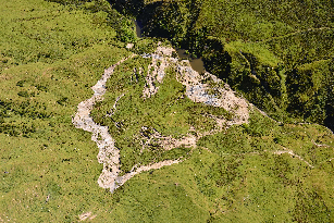
There were several large (100m x 100m area) slips observed on the Puketoi Range, and in the Puketoi foothills. Three of these had failed while several showed cracking and emerging slumping, with one damming a small stream at the toe of the slip near Haunui.
Near Makuri, several large limestone boulders were dislodged from the ridge and had rolled down the slopes below. There were fresh exposures along steep cliffs of small streams and collapses onto the road in the Saunders Rd and Makuri Gorge areas. Some minor shallow landslides were seen in the hills between Alfredton and Eketahuna, although some of these may have been rainfall induced. Cracks were observed on roads in the Makuri Gorge and on Pori Rd and minor cliff collapse and rockfalls were observed on the Ruamahanga River, south of Mount Bruce.
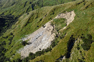
Large Landslide in the Puketoi Range Foothills
Large landslide in the Puketoi Range foothills, showing dammed lake at the toe of the slip.
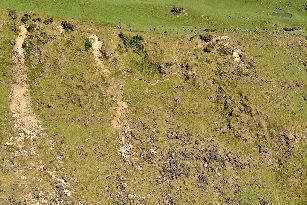
Rockfalls and cracks on a slope above Pahiatua