Update on minor eruptions at Whakaari/White Island
Since, Friday 24 May we have observed three gas-driven eruptions at Whakaari/White Island. We take a closer look at what has happened and what may happen next.
Timeline of Activity
Friday 24 May
The first observed eruption was on Friday 24 May at 08:20 am. This was captured by our Whakatāne based camera. We observed a steam and gas plume rising between 2-3km above the island.
In response to this activity the Volcanic Alert Level was raised from VAL2 to VAL3, which means a minor volcanic eruption has occurred.
An observation flight in the afternoon confirmed geysering activity was stronger than what our scientists had seen in the last few months, regularly ejecting material 20-30 m high for several seconds. These observations suggested that the eruption on Friday was most likely steam-gas driven, and there were no indications of fresh magma being close to the surface. With no evidence of further eruptions since that morning, the Volcanic Alert Level returned to VAL2.
Watch: Video of eruption on 24 May
Saturday 25 May
At 08:10 am on Saturday there was more minor volcanic activity with a steam-gas plume seen above the island. Footage from our Whakatāne volcano web camera captured this activity and confirmed, minor volcanic eruptive activity with intermittent energetic ejections of steam and gas was again occurring. Activity at the volcano seemed to remain high and at around midday on Saturday, we observed another short-lived eruption. The Volcanic Alert Level was again raised to Level 3 to indicate a minor volcanic eruption has occurred.
Sunday 26 May
Throughout Sunday, the activity appeared to be quite limited, however views of the island were periodically hampered due to cloud. It is difficult to determine if or when further eruptions occurred on Sunday.
Monday 27 May
A gas flight today provided a chance for our scientists to see into the active crater. Photos and video show that the crater lake has changed significantly due to the eruptive activity. The vent area appears to have been modified and the crater lake has dropped in height. During the flight, we were able to measure the gas emissions and will analysis these.
The volcanic unrest has continued, and we are intermittently seeing the more typical steam and gas emissions when views are clear. The Volcanic Alert Level remains at 3.
What will happen next?
This current activity indicates that Whakaari / White Island may be entering into an eruptive episode, with pulsating periods of energetic steam and gas emissions that may contain minor volcanic ash concentrations. There are no obvious signs that eruptions will become much more energetic, but this could occur with little to no warning.
Should future eruptions become larger, producing volcanic ash, and should the wind direction change, it is possible that ash could be dispersed onshore. Over the last 30-40 years it has been rare for ash from Whakaari / White Island to reach the coast.
Read: Volcanic ash
How do Volcanic Alert Levels Work?
In New Zealand, we use a system of Volcanic Alert Levels to define the current status of each active volcano. The alert levels range from 0 (no volcanic unrest) to 5 (major volcanic eruption)
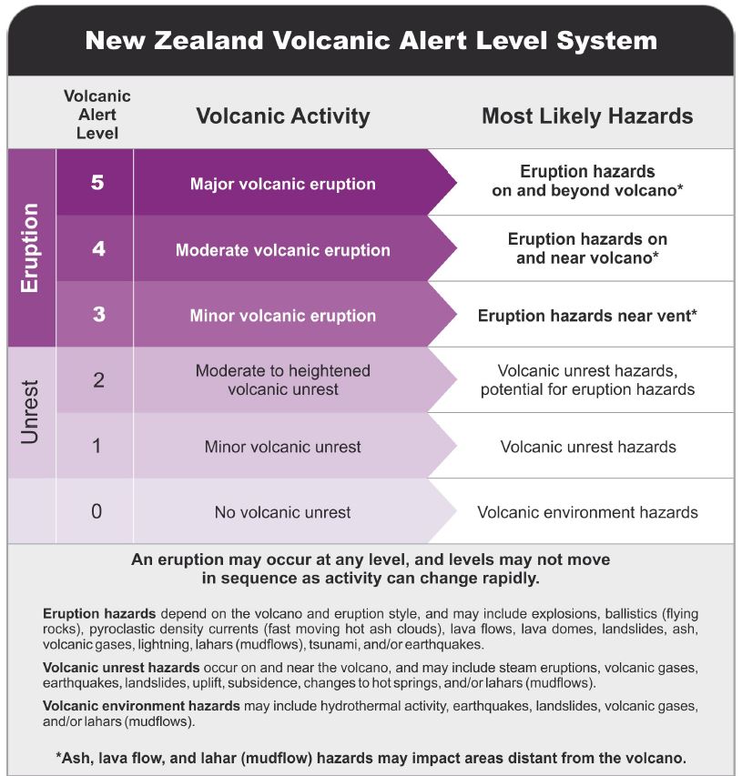
New Zealand Volcanic Alert Level System
Watch: Volcanic Alert Levels in NZ.
How do we monitor Whakaari/White Island?
GNS Science’s National Geohazards Monitoring Centre and Volcano Monitoring Group, through the GeoNet programme, continues to monitor Whakaari / White Island for any signs of unrest or further activity. Further information will be released as available. As that information becomes available, we may change the Volcanic Alert Level to reflect the current situation more accurately.
Currently we do not have access to Whakaari, which means we have been unable to service or replace our monitoring equipment. As we have no working sensors on the island, we are currently relying on our remote monitoring toolkit.
This toolkit includes monitoring stations on the mainland, observation and gas flights, and remote sensing technology, like radar, gas, and thermal satellite imagery. MetService’s Volcanic Ash Advisory Centre (VAAC) provide us ash and SO2 data via remote satellite.
We also receive information about Whakaari from satellite data from the German and European Space Agencies, which can provide us a view of ground deformation and gas emissions.
GNS Science works closely with Emergency Management Bay of Plenty and other local authorities to ensure they have the science information they need to give public advice and help keep people safe.
GNS is currently working alongside NEMA, Ministry of Transport and Civil Aviation Authority, to mitigate the risk of our reduced monitoring service on Whakaari/White Island and determine future monitoring requirements, you can read more here.
How to be prepared
The Bay of Plenty Emergency Management website has information for the community here.
The National Emergency Management Agency's (NEMA) Get Ready website has information on what to do before, during and after volcanic activity.
EQC Toka Tū Ake have information for preparing your home for natural hazards.
Find out more about Whakaari volcano
How do we monitor our volcanoes?
Attributable to: Geoff Kilgour, Volcanologist.
Media Contact: 021 574 541 or media@gns.cri.nz