Southern Site Selection
GeoNet maintains more than 700 permanent monitoring sites around Aotearoa New Zealand. These sites contain hundreds of sensors that gather data on ground movement and shaking from earthquakes. That data underpins our understanding of the geohazard events we face in New Zealand, particularly earthquakes.
We are always improving our sensor network to increase monitoring station density and improve research and response capabilities. The more instruments we have when a major event such as a large earthquake happens, the better high-quality data we will have to assess and understand the event.
The process to get these sites up and running begins with site selection. We spoke to Science Operations Specialist, Sam Taylor-Offord, who had just returned from a site selection trip in the South Island.
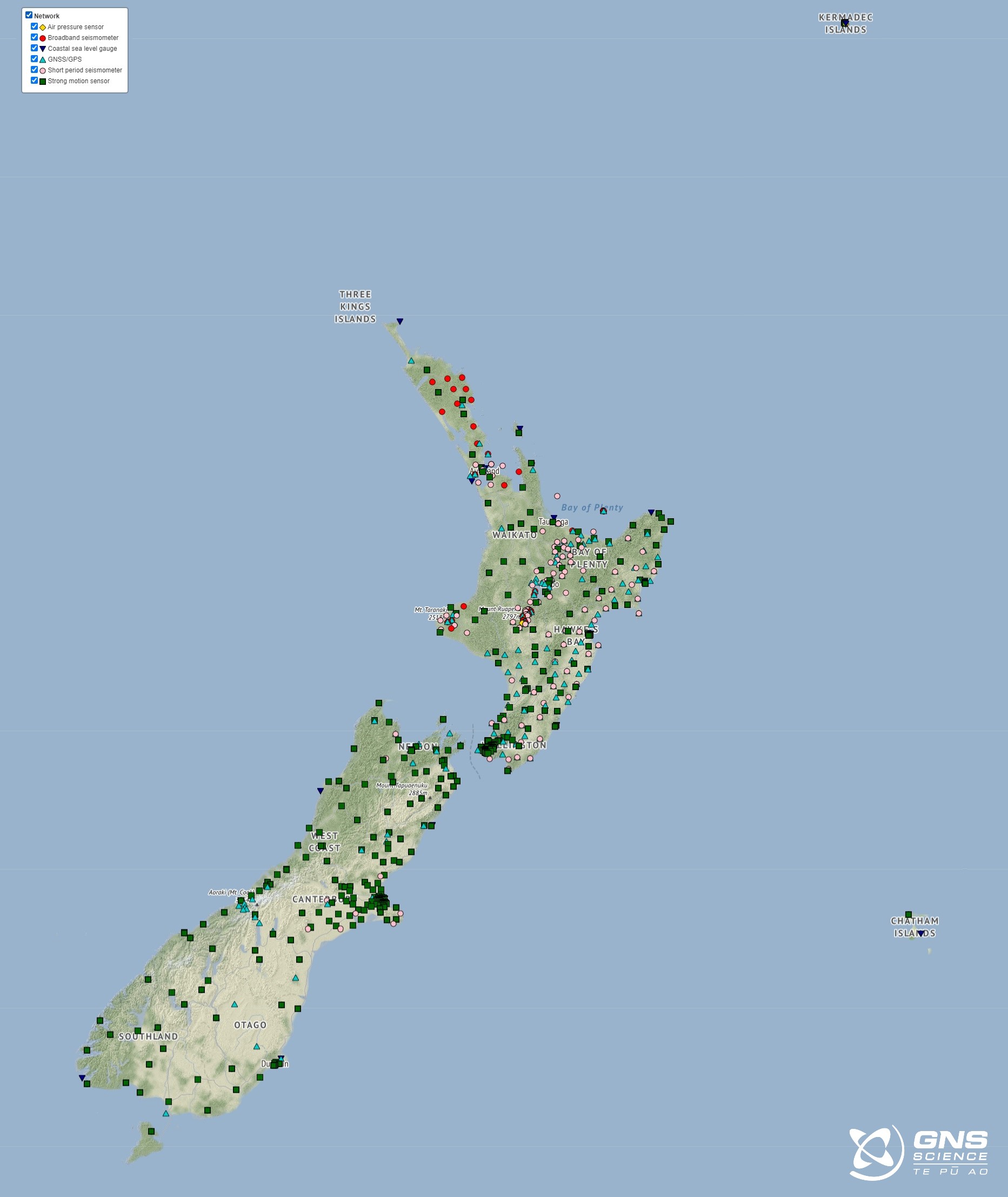
GeoNet Sensor Network as of August 2023.
What is involved in site selection?
Site selection is all about designing the best network on paper, in the office, and then finding real locations to build this network on the ground. In general, our sites are well distributed across the country, but there are situations where events can highlight gaps or limitations in our monitoring network in local areas.
“It’s a game of maximising what works well and minimising what doesn’t, and making sure every station location has core capabilities, like internet access and power,” Sam explained.
“In “green fields” site selection we can have multiple options in an area where we want to put one station. Then we can perform test data acquisition and make exploratory site visits to try and work out which option will provide us the most useful information.”
“The GeoNet team considers the recommendations of scientists, and then visits sites, performing site explorations and internet testing without the need to invest in weeks of test data collection.”
“If we need test data, we can just use the research data. That’s teamwork!” Sam says.
What did you get up to on this trip?
“This trip was all about checking recommended site locations for core capabilities,” Sam explains.
“We visited six sites, five requiring helicopter access. For each site we tested cellular coverage, solar power potential, ground stability (a big issue in the mountains), and basic things like where we would put our infrastructure.”
“Often the best location for science is not the best on the ground, so we test a few locations in each selection area to make sure we have options.”

This is the view NE at the Solution Ranges site. This flat spur is a strong schist where researchers have a site. We intend to build where Tim is in the photo, which is just back from the edge.

This is the famous red hills of the Dun Mountain ophiolite. Half of these are up in Nelson moved along by the Alpine Fault. The landscape is remarkable.
What happens next?
With lots of information and options to hand, the GeoNet team will reconnect with the researchers who recommended the original locations. Together, they pick the best sites.
“Then we can work with the landowners to get permission to build,” Sam says.
With a large portion of our network located on private land, we are grateful for the landowners who allow us to install our vital instruments on their land.

The view west from our site at Haupiri. Here we would like to build a GNSS and a seismic site to expand the network capability in the NE reaches of the Alpine Fault, which runs just past this
Earthquakes can occur anywhere in New Zealand at any time. In the event of a large earthquake: Drop, Cover and Hold.
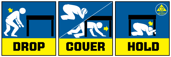
Drop, Cover and Hold
Remember Long or Strong, Get Gone : If you are near the coast and feel a strong earthquake that makes it hard to stand up OR a weak rolling earthquake that lasts a minute or more move immediately to the nearest high ground or as far inland as you can, out of tsunami evacuation zones.
Know what to do?
The National Emergency Management Agency (NEMA) has a great website with information on what to do before, during and after an earthquake.
Prepare your home. Protect your whānau.
There’s a lot we can do to make our homes safer and stronger for natural disasters. Toka Tū Ake EQC’s website has key steps to get you started.
Media Contact: 021 574 541 or media@gns.cri.nz