Hawkes Bay Slow Slip Earthquake
Eagle-eyed visitors to the GeoNet website will have spotted a slow-slip earthquake (SSE), that our GNSS instruments have located near Hawkes Bay during the month of June. Today we give an update on what’s been happening beneath our feet.
The slow-slip earthquake lasted three weeks, beginning around June 10, and the activity appears to have mostly wrapped-up by the end of June. We are still monitoring closely for any continuing movement.
The slow-slip earthquake generated 5-8 centimetres of movement between the Australian and Pacific Plates, along the Hikurangi subduction zone. It occurred 12 km below Hawkes Bay, with much of the movement taking place beneath Mahia Peninsula. To put this in perspective, 5-8 centimetres of movement represents one to two years’ worth of plate motion taking place in only three weeks.
A continuously operating GNSS site at Mahia Peninsula was displaced eastward by approximately 2 centimetres over the three-week slow earthquake, and about half a centimetre of surface displacement was observed by GNSS sites as far south as Cape Kidnappers.
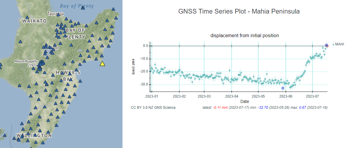
GNSS site position changes at Mahia Peninsula showing eastward movement during the June slow slip event. Note that the east movement in the last few days of data shown (mid-July) is most likely due to noise in the most recent data points.
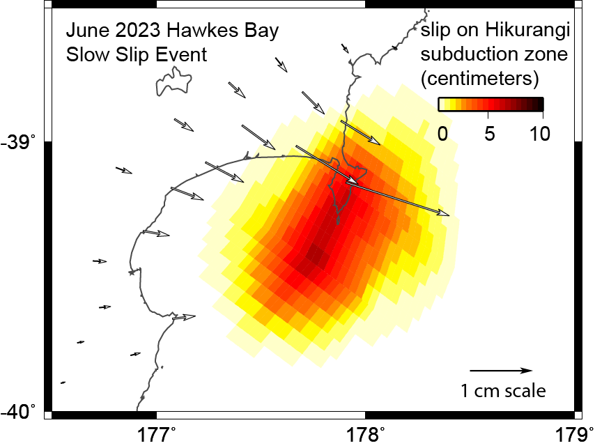
Image showing the movement that occurred on the Hikurangi subduction zone during the slow slip event near Hawkes Bay in June. The arrows show how our continuous GNSS sites were displaced during the event.
The movement on the plate boundary during the event released energy equivalent to a Magnitude 6.6 earthquake. As this release of energy took place slowly, over a period of weeks rather than seconds, it did not cause shaking that is able to be detected by our seismographs. Instead, it is our continuously operating GNSS instruments, that track millimetre-level movement of the land daily, that allow us to see events like this unfold. We often see slow slip events in the Mahia and Hawkes Bay area, with the last event that we reported on at about the same time last year.
There is another, much slower and deeper (25-45 km depth), slow earthquake that is still ongoing beneath the Manawatū and Kapiti regions, which started a year and a half ago. The latest phase of movement in this event in the last two months has been occurring beneath the Manawatu region. As always, we are keeping an eye on this slow slip event and will keep you posted as it evolves.
We often see slow slip earthquakes offshore of the east coast of the North Island (like the June Hawkes Bay event) take place simultaneously with the deep, long-term Kapiti and Manawatū events. In 2010 and 2011 we saw a sequence of slow slip events offshore of the east coast during a large Manawatu slow slip event.
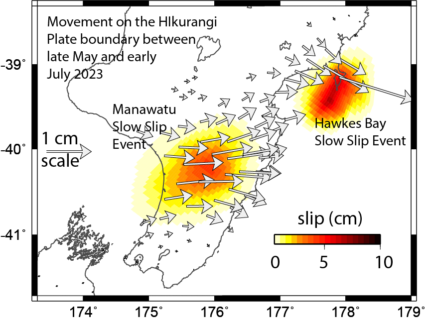
This image maps the movement on the Hikurangi subduction plate boundary during the most recent phase of the ongoing Manawatu Slow Slip Event, between late May and early July 2023 and the simultaneous movement of the June Hawkes Bay event. The arrows show horizontal movement of GeoNet GNSS sites since late May.
Learn More:
- Watch our video explaining what slow slip events are
- View the latest GNSS movement on our website
- May 2023 slow slip update
Slow-slip events are a great reminder that we Kiwis live on a very active tectonic plate boundary!
If you feel an earthquake: Drop, Cover and Hold. If you are near the coast and you feel a Long OR Strong earthquake, get to higher ground or as far inland as possible once the shaking has stopped in case a tsunami has been generated.
For more information on how to get you and your whānau prepared, visit the National Emergency Management Agency’s website getready.govt.nz.
For information on how to prepare your house for earthquakes, check out Toka Tū Ake EQC’s advice for homeowners and renters.
Special thanks to: Laura Wallace – University of Texas and GEOMAR, Germany
Media enquiries: media@gns.cri.nz or 021 574 541