
Reflections on the April 27 White Island (Whakaari) eruption
On Wednesday, 27 April 2016 a moderate steam and gas driven eruption occurred at White Island (Whakaari).
The eruption ejected the Crater Lake, created a new crater, generated landslides/collapse and excavated some of the Crater Lake floor. This generated a very energetic blast that covered much of the Main Crater floor and the north eastern portion of the volcano with green tinged ash. This eruption occurred during a period of volcanic unrest, however we were challenged initially to confirm it had happened. These steam and gas driven events do not give any useful warning.
Detecting the eruption To confirm there has been an eruption you need 2-3 definitive pieces of data; typically in volcanology that is seismic and acoustic recordings of the ‘explosion’, maybe ground deformation and visual observations. The April 27 eruption at White Island challenged us on all of these, mainly because it happened at night in an isolated area.
The best data are usually the seismic and acoustic (air pressure waves from explosions), however seeing it happen cannot be beaten. This eruption occurred around 9.30-10 pm and no one was on the island. We recorded a complex pulse of seismic data that lasted about 1½ hours, starting around 9.31 pm. The largest and most energetic portion was at around 9.53 pm, suggesting the eruption climaxed about then. The size of the signal was also ‘small’ compared to past activity (2011-2013), and the acoustic signals were not clear, and were difficult to interpret.
Our gas sensors only work in day light, and need the gas plume to be over them. The web cameras also work best in daylight, although they can gives useful images at night, especially when there is a bright moon. What we didn’t know on the evening was that the blast deposit obscured our web camera on the north rim, so even as the sun came up we still couldn’t see to confirm the activity. Nothing very definitive to work with here, hence we couldn’t confirm the eruption on Wednesday evening.
In hindsight, we now have great images from the NZ MetService rain radar that shows an eruption plume reaching to 3 km by 9.52 pm and over 4 km at 10:00 (It takes 7 minutes for the rain radar to collect a full image). The GPS on the Main Crater floor didn’t record any ground deformation, however there is an apparent ‘shift’ which starts around 9.30 pm and continues to 10.24 pm which we now believe was the antenna losing signal or been coated by ash. Detailed post event processing also shows there are acoustic Signals but they remain inconclusive.
Confirming the eruption As the day light grew on Thursday morning we were able to see from the Factory camera (Dino) there was an indication of a new deposit. Later in the morning, we also noted that two of our solar panels didn’t start to charge batteries, detected via our battery monitoring systems, suggesting they were covered in ash.
We knew something had happened but it wasn’t until GNS volcanologists flew over the volcano in the afternoon they were able to fully appreciate the impacts of the previous night’s eruption. A dark yellow-green ash deposit from the eruption covered about 80% of the floor of Main Crater, blasted high up the sides of the crater wall on both the north and south sides. At a distance of 500 m from the eruption site the ash deposit is about 5 mm thick. It extended off the island to the north east.
Impacts and Hazards The surge deposit obscured our web camera on the north rim, the crater floor GPS , along with all of the solar panel arrays. GNS didn’t consider it safe to visit the Main Crater floor however staff did service the equipment outside of that area to ensure valuable monitoring data continued to reach our volcanologists.
The eruption deposit at the North rim site was typical of what volcanologists refer to as a hot volcanic surge deposit. It was plastered on sides facing the vent, but was absent on shaded/protected surfaces. This indicates the surge travelled horizontally, across the crater floor, so the ash did not fall from the sky as often occurs. It has a texture like ‘apple crumble’ and was very dry, this indicates it was very hot when deposited. Survivability during the eruption would have been low on much of the crater floor.
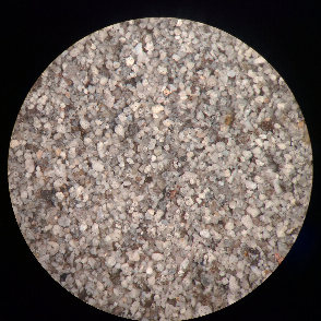
White Island ash under microscope; 250 um size
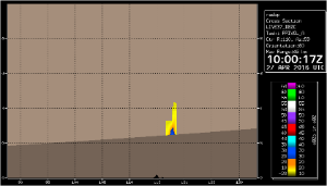
NZ Met Service radar image of the eruption plume
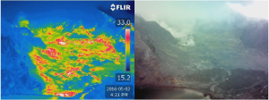
Thermal image of crater floor area at White Island
Questions about White Island (Whakaari) that you were too afraid to ask So, last Wednesday evening, White Island erupted with no warning. Not a huge event. However the eruption had a really big impact on the island. We are still making sense of all the data we have got so far and are yet to examine the Main Crater floor in detail due to the risk to our staff. We’ve put together some of the questions we’ve been getting asked as well as some questions that haven’t been asked yet, but we think are important. Right, first up:
Q. What’s up with that green ash? Is that mineral makeup? No, thanks Twitter. It is NOT mineral makeup. That amazing green colour was created from a unique combination of minerals on White Island. The ash contained quite a bit of pale yellow sulphur which appeared as irregular shaped lumps, and some translucent golden yellow grains. This is consistent with the colour of the deposit. Q. Was there any juvenile material found in the ash? No. The reason we test for juvenile material is to determine whether there was new magma (lava) coming up OR whether this was older material. New material could indicate that this would have been the start of a whole new phase of activity for White Island; however, in this eruption it only tossed out old lake sediments and crater wall material. For people who want more science, here it is: The volcanic blast deposit collected from the North rim site solar panel was found to have no new juvenile material. Most of the ash is strongly hydrothermally altered old rock fragments, with some fresher fragments of volcanic glass and crystal. However these are attached to or form a partial coating of white to pale grey hydrothermal altered material. From our past experience of examining White Island ash we are confident that this is not April 2016 magma (new stuff. When no juvenile material is found, this means that new magma was not involved in the eruption. Q. If people were hanging around the crater during the eruption, would they have survived? We are really happy the eruption happened at night. The blast would have been travelling fast and was hot hence survivability during the eruption would have been low in many areas of the crater. Q. What can you tell us about this new vent? During the visit on Thursday afternoon we obtained some thermal images of the crater area, and during the aerial inspection on Friday to measure the gas output we had better views of the 1978/90 Crater area. From the photography and thermal images we were able to identify the location of a new vent that had erupted on Wednesday evening. Significant collapse had also occurred in this area, formally known as Donald Duck Crater (in no way related to Dino). Several meters of Donald Mound have collapsed into the 1978/90 Crater area, taking away our target that was used to calibrated measurements from our web camera images. It had been repainted only 6 days before. Q. Are we going to call this new vent Venty McVentface? No. Not even once. Stop asking us that, Reddit. We are much more boring, we go for month/year so we can keep track of them ... once you have 20-30 vents with cool names it becomes a challenge! We have had some great ones; Orca, Gilliver, Rudolf, Donald Mound, Christmas, Noisy Nellie, RF, PJ, TV1, Blue Duck, Donald Duck (when Donald mound and Blue Duck joined), Big John, GIBRUS, just to name few along with the boring ones like 1931, 1971, 1978/90. Q. Why did the Volcanic Alert Level get lowered so quickly? Following the eruption the volcano did not start to produce volcanic ash from any of the active vents. The seismic activity remained at relatively low levels and gas emission data indicated SO2 output was at levels similar to those prior to the eruption. As a consequence of the continued lack of activity after the eruption, the Volcanic Alert Level was lowered to Level 2 on Thursday evening. This indicated that the volcano was not erupting but remained in a state of moderate to heightened volcanic unrest. Q. What’s going to happen next with White Island (Whakaari)? That’s the $64 million question!. White Island is by far one of our most active volcanoes. Heightened volcanic unrest continues at White Island (Whakaari) and no eruptions have occurred since April 27. Volcanic gas output and seismic activity which is dominated by volcanic tremor increased in 2011 when volcanic unrest developed. That led to the eruptions in 2012 and 2013. These two unrest parameters remain elevated and have defined a ‘new background’. The possibility of further eruptions remains high and the Volcanic Alert Level remains at Level 2 (moderate to heightened volcanic unrest). White Island can and does continue to intrigue us, providing us rich scientific data that increases our understanding of volcanoes in New Zealand and around the world. We aren’t entirely sure what the volcano will do next.