Keeping an eye on Taranaki Volcano
Mount Taranaki dominates the skyline of the Taranaki region. Standing 2,518 metres high it is hard to miss. Equally hard to disregard is the evidence of many past eruptions that this active volcano has left in the landscape. The regions productive farming industry is nourished by the rich soils produced by past volcanic activity.
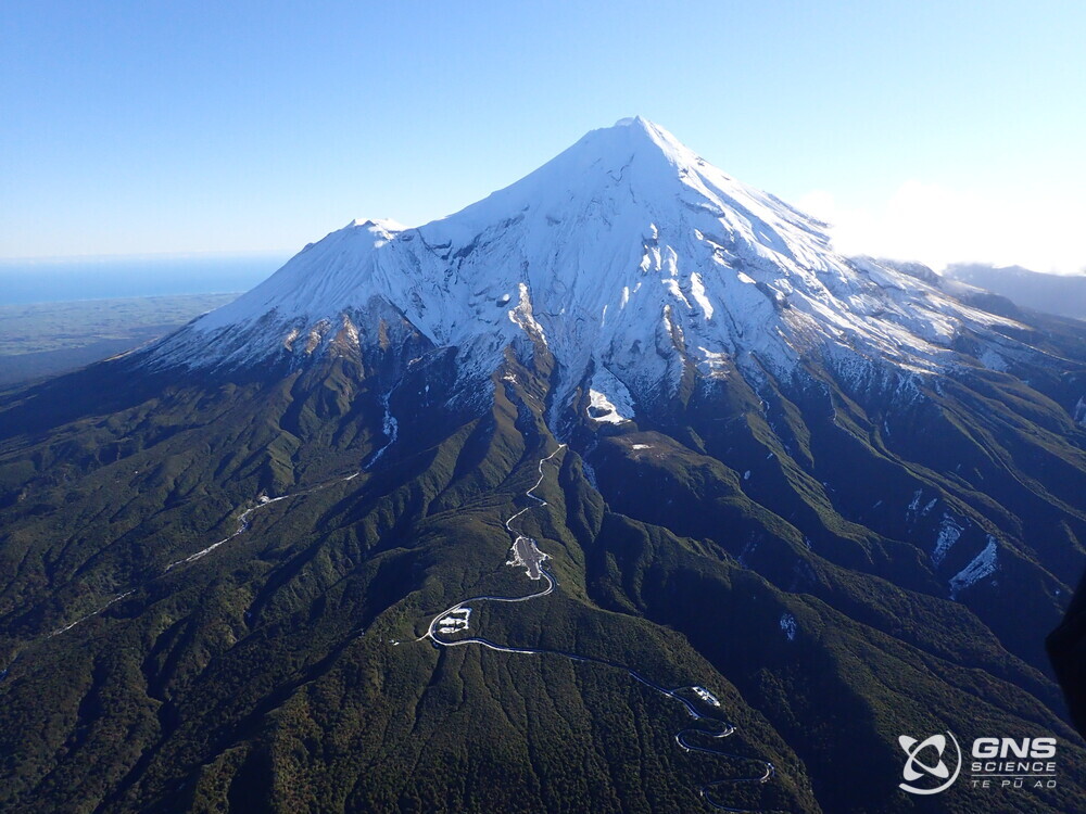
Mount Taranaki
Mt Taranaki is a cone volcano that began forming about 130,000 years ago and research of its volcanic history has shown that a wide variety of eruptions have occurred over time. Studies have also shown the volcanic cone has collapsed and consequently rebuilt itself in the past. The volcano last erupted about 150 years ago.
Based on an analysis of eruptions over the last 30,000 years, researchers estimate the probability of further eruptions at between one and 1.3 percent each year.
“Although the probability of an eruption in any one year is low, the risk of an eruption will be significant to our communities” says Todd Velvin, Group Manager, Taranaki Emergency Management Office.
How GeoNet monitors Mt Taranaki
In recognition of the future risk of volcanic activity and to help mitigate the possible impacts, GeoNet operates a robust volcano monitoring network to support the Taranaki region.
Research has shown the most likely indicator of Taranaki reawakening will come in the form of earthquake activity under the volcano. The earthquakes would be created by new molten material (magma) making its way towards the surface. This form of volcanic unrest would indicate the volcano is waking, but this is not happening currently.
GNS Volcanologist Brad Scott says “Annually, GeoNet locates around 300 earthquakes in the Taranaki region. Since detailed monitoring started in the early 1990’s no volcano related earthquakes have been recorded”
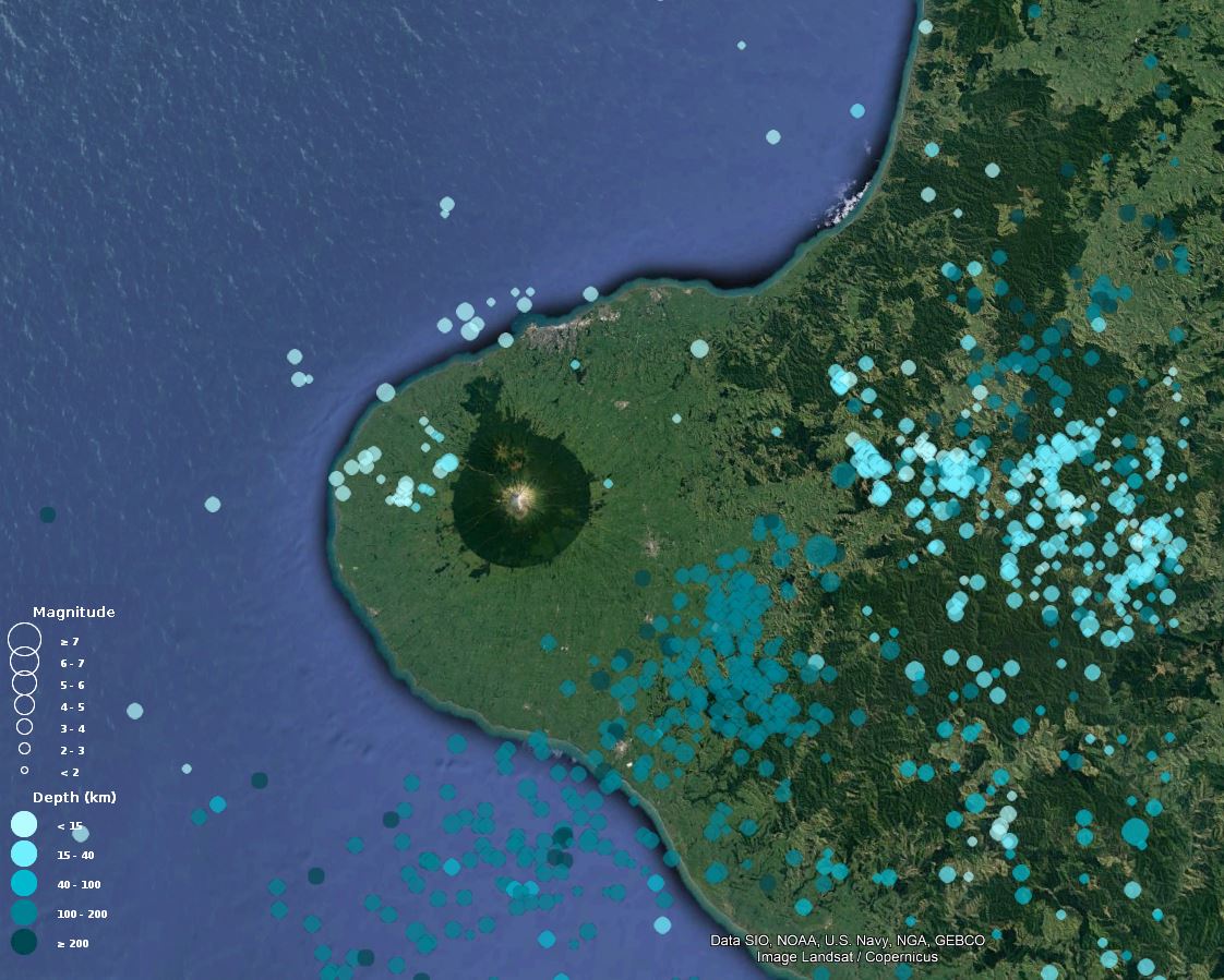
Earthquakes located in the Taranaki region in 2022
Other indications of the volcano reawakening could include changes in ground deformation and activity in warm springs. GeoNet operates GPS-GNSS instruments on and near Mt Taranaki to detect ground deformation. We also have monitoring in place at the warm springs at Arawhata Road, as well as keep watchful eyes on the volcano with a webcam.
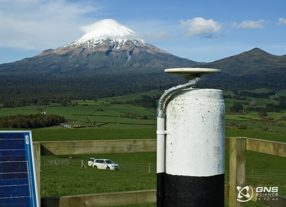
GNSS site at German Hill
Volcanic hazards
Like much of New Zealand, the Taranaki Region faces many hazards. Volcanic hazards are a priority for the team at Taranaki's Emergency Management office (TEMO). GNS scientists work closely with TEMO to help them understand the volcano, recently supporting the team to create a series of infographics about volcanic hazards at Taranaki.
Taranaki Group manager, Todd Velvin, understands the significance of volcanic hazards in Taranaki and encourages readers to make use of the rich resources on the Taranaki Emergency Management web page, including information about what to do before, during and after a volcanic eruption.
Links
The Taranaki Emergency Management website
What to do during a volcanic eruption
Information for after a volcanic eruption
Ongoing research
The significance of the volcanic hazard in Taranaki is also the focus on a five-year MBIE-funded programme. This programme considers the many elements of the impact of a volcanic eruption in Taranaki, including modelling the economic impacts, volcanic hazards, eruption processes, products of eruptions and the impacts on infrastructure.
One recent study has highlighted how quickly some phases of an eruption can occur at Taranaki volcano. However, it's important to note that the volcano must already be in eruption for this to happen. With our extensive monitoring network around Taranaki volcano, and our 24/7 monitoring centre (NGMC) we will be able to detect any future reawakening of the volcano.
Although we cannot prevent natural hazards, we can prepare for them – and we should.
The National Emergency Management Agency's (NEMA) Get Ready website has information on what to do before, during and after volcanic activity.
During volcanic activity, follow official advice provided by your local Civil Defence Emergency Management Group, the Department of Conservation (for visitors to the Tongariro and Taranaki National Parks), local authorities and emergency services.
Prepare your home. Protect your whānau.
There’s a lot we can do to make our homes safer and stronger for earthquakes. Toka Tū Ake EQC’s website has key steps to get you started.
Media contact: 021 574 541 or media@gns.cri.nz