
Coastal Uplift: How has the Kaikoura Coastline Changed
Updated: Mon Nov 21 2016 2:00 PM
UPDATE Monday 21st November
Over the weekend we conducted further reconnaissance trips via helicopter to refine how the Kaikoura Earthquake uplifted areas of the East Coast of the upper South Island. This is a map of preliminary coastal uplift measurements along the Kaikoura coastline from the Conway River to Cape Campbell. We have compiled three sets of uplift observations for this map. The most accurate information is from the tide gauge (green dot), but we only have one tide gauge in the area, located at Kaikoura. The measured points (red dots) show locations where GNS Science and University of Canterbury teams surveyed the coastal uplift. Biological markers of pre-earthquake tide levels were surveyed relative to the post-earthquake tide levels. The range in values reflects the elevation range of the biological markers and the uncertainty in surveying methods and the tidal correction. The helicopter points (blue dots) represent areas where we estimated the amount of uplift from our helicopter observations during high tide and low tide survey flights, these have the largest amount of uncertainty. Survey teams will revisit the area again this week to increase the density of our observations.
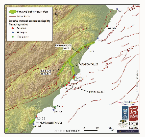
Preliminary coseismic coastal uplift measurements
Our preliminary insights from this work is that coastal uplift is highly variable along the Kaikoura coastline. The startling uplift of ~5.5 m at Waipapa Bay is a localised block pushed up between two traces of the Papatea Fault and is thankfully not representative of the whole coastline. The surveys teams would like to thank the residents of the Kaikoura coastline who have been so welcoming to scientists, hearing the resident’s observations of the coastline and the impact of the earthquake has been hugely valuable and we hope that our post-earthquake science survey can contribute to our knowledge base of these very rare, but hugely impactful events.
The maximum coastal uplift was near Waipapa Bay on a relatively small block of crust pushed up between two strands of the Papatea Fault.
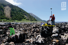
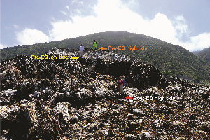
Earthquake geologists from GNS Science and marine biologists from University of Canterbury surveying coastal uplift.
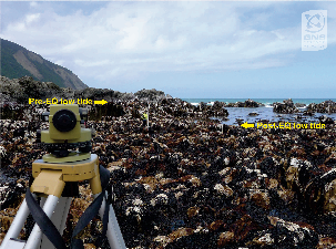
Surveying at a coastal uplift site near Half Moon Bay, on the southern side of the Hope Fault, uplift here is 2.1 – 2.4 m.
Much of the northeastern coast of the South Island was uplifted during the 14th of November 2016 earthquake. We know this from photos of rock platforms covered in seaweed and marine animals such as crayfish and paua stranded above tide levels. Our records measured the tide gauge at Kaikoura was lifted up by 1 m, and continuous GPS monitoring sites at Kaikoura and Cape Campbell were also raised by 0.7-0.9 m. At this stage we can estimate that the coast was raised between 0.5 m and 2 m from about 20 km south of Kaikoura all the way north to Cape Campbell. Scientists plan to find out more about this coastal uplift.
What is coastal uplift? Coastal uplift is when the land is raised above the sea by tectonic forces. It can happen gradually over geological timescales or suddenly by an earthquake.
How does it happen? Sudden coastal uplift happens as the result of large earthquakes. Vertical movement on a fault can cause land to be pushed up. This is the type of movement that has built many of the mountain ranges in New Zealand. When such vertical movement on a fault happens near the coast, land is raised above sea level. Sea level is a powerful horizontal marker for measuring tectonic movement because it is very obvious which land used to be under water before the earthquake!
Is coast uplift normal? Coastal uplift is normal for large earthquakes near the coast that include some vertical movement on a fault. Most movement on the faults that ruptured in the Kaikoura M7.8 earthquake was horizontal, but there was some vertical movement too, so it is not surprising that there has been some coastal uplift from this event.
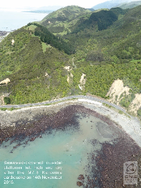
Kaikoura- view from above
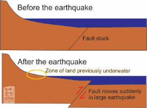
Uplift diagram
In New Zealand there is evidence preserved in the landscape that shows many parts of the coast have been repeatedly uplifted through time. For example, raised marine beaches and terraces along the Kaikoura Peninsula, Wairarapa coast, Cape Kidnappers, Mahia Peninsula, north of Gisborne and East Cape, are evidence of former beaches that were uplifted from the sea by earthquakes in prehistorical times. Many of these have been or are currently being studied to find out the size and age of past earthquakes.
Historical examples In historical times we have had several examples of earthquakes causing coastal uplift that, although devastating in the short term, have led to some benefits. For example, in 1931 the M7.8 Hawkes Bay earthquake raised land around Napier by 1-2 m above sea level. Land that used to be estuary now provides space for Napier airport. In 1855 the M8.2 Wairarapa earthquake raised much of Wellington by 1-2 m. The road from Wellington city to the Hutt Valley became viable as a result of the new land around the harbour’s edge.
Will the land go back down? Probably not. The newly raised coastline of the Kaikoura coast is most likely a permanent feature. Historical and pre-historical examples show that in many parts of New Zealand these raised beaches remain high above sea level. However, in some parts of the world, raised beaches have been known to gradually drop down again (over centuries) or be dropped down suddenly in a large earthquake with a different sense of movement.
What will happen to all the sea creatures? There will be a major shift in the community of marine species. Many seaweeds and animals that would normally be permanently covered by water will now be struggling to exist in a zone of transition between air and sea. Some of the animals that have been raised will be accustomed to air exposure for short periods of time, but not the full tidal cycle that they will now experience. As the animals not suited to this environment die from the reef, they will be replaced by seaweed and animals appropriate for the new tidal level.
__What are scientists doing to study the coastal uplift and its impact? __ There are several studies being planned by geologists and biologists. Over the next weeks and months geologists will be undertaking surveys along the coastline to measure the amount and extent of coastal uplift that has occurred. Recording this information will help us to understand which faults ruptured in the earthquake, and how much slip occurred on those faults. Over the coming weeks marine ecologists and fisheries scientists will be surveying areas on the rocky shore to understand the sequence of change. The surveying will continue for in the long-term for changes to be captured.
The information collected by scientists will be publicly available.
Can the public contribute their photos and observations? YES! The coastal uplift covers a long stretch of coastline and the scientists will not visit every location. We are interested in photographs of: - displaced coastal features such as the uplifted reefs and rock platforms; - displaced marine life especially before and after photos if animals are being rescued and removed from the reefs; - uplifted man-made structures such as jettys and boat ramps particularly if they have tide level markers on them. We are also interested in people’s observations, particularly residents who have familiarity with the coastline pre- and post-earthquake. To be of most use, we would like to know the location, date, time of the photograph and if possible, context and scale.
As always your safety comes first, please do not put yourself at risk to collect this information.
Photographs and information can be sent to: k.clark@gns.cri.nz
Citation for map: Clark KJ, Goldstein S, Villamor P, Berryman KR, Gerrity S. 2016. Preliminary coseismic coastal uplift measurements from the 2016 M7.8 Kaikoura earthquake. GNS Science.