Icelandic Volcanic Unrest – how we’re helping and what it means for New Zealand
On 27 October 2023 magma started accumulating beneath the Reykjanes-Svartsengi volcanic system in Iceland. Located just 3.5 km north of the town of Grindavík with a population of 4000 people. Grindavik is a popular tourist spot for the geothermal activity and supports the fishing industry from its port.
The movement of the magma caused a rapid uplift (1 cm/day) and has triggered thousands of earthquakes. On 10 November 2023 intense seismic swarm and deformation suggested the magma was moving along a several kilometre long zone and had started shifting towards the town of Grindavík, causing rapid ground deformation (subsidence and extension).
Modelling of Global Navigation Satellite System (GNSS) and Interferometric Synthetic Aperture Radar (InSAR) data suggested that the 15 km long intrusion was forming, what is known as a ‘dike’, extending beneath the town of Grindavík and reaching shallow depths (< 1 km). A GNSS station north of Grindavík subsided over 1m in 24 hours. GNSS and InSAR data continue to show magma inflow into the volcano with hundreds of earthquakes occurring daily. While no eruption has taken place yet, the likelihood of an eruption is considered high according to the Icelandic Meteorological Office.
Ground movement along with seismic activity is a key to understand magma propagation during volcanic unrest. Using GNSS and InSAR data we can estimate the depth and volume of magma intrusions. The style of volcanic activity that occurs in Iceland can develop from unrest to eruption very quickly (days-weeks). During unrest it is important to get as accurate information in as short period of time as possible for early warning.
Sigrún Hreinsdóttir, GNS Science Geodetic Scientist is working with the Icelandic Meteorological Office and University of Iceland. Sigrún, like other scientists right across the globe, are operating as a community and many are sharing their expertise to support the monitoring team.
To this aim, Sigrún has been developing methods to provide rapid-sub centimetre level accuracy of site positions every few hours. Collaborating with scientists at Icelandic Meteorological Office and University of Iceland she set up analysis to provide scientists in Iceland with site positions at key stations around the volcano every four hours. These data are then used to model the propagation of the dyke.
If you want to follow the updates from Iceland, visit the official monitoring agency, Icelandic Meteorological Office.
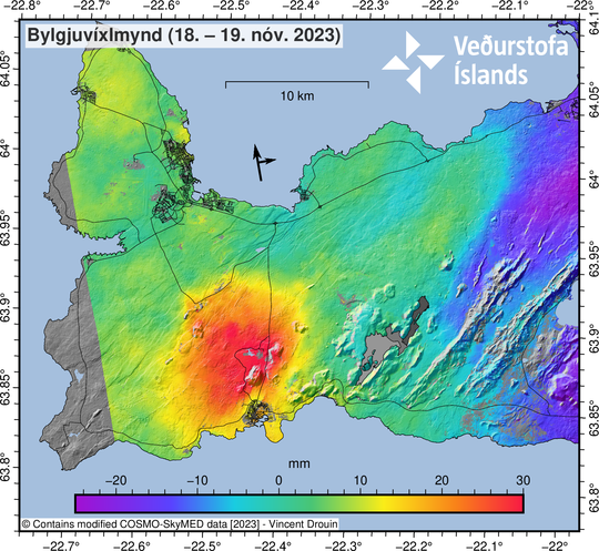
Satellite based observations (like COSMO-Skymed) are able to show areas where ground deformation is occurring, in this case uplift (in mm) as the molten material pushes towards the surface. Courtesy of Icelandic Met Office.
Could this happen in New Zealand?
New Zealand has a different volcano-geological setting to Iceland. However, the most similar volcanoes we have are those in the Auckland Volcanic Field. There have been over 50 eruptions in the Auckland area over the past 193,000 years, with the most recent eruption occurring about 600 years ago, forming Rangitoto Island. Auckland volcanoes tend to mainly produce runny lava flows and volcanic gas, similar to those in Iceland. Unrest as magma rises would likely generate earthquakes and ground cracking also similar to Iceland.
While it is entirely possible that we will have another eruption in Auckland in our lifetimes, the chances are low. GNS Science monitors the Auckland area for earthquakes and ground deformation. We would communicate any changes to the level of activity via Volcanic Activity Bulletins on the GeoNet website, and work in coordination with Auckland Emergency Management.
How do we monitor volcanic activity in Aotearoa New Zealand?
GNS Science monitors all New Zealand’s active volcanoes for signs of activity and provide updates via Volcanic Activity Bulletins. We monitor for earthquake activity, ground deformation and changes in water and gas chemistry.
We use the Volcanic Alert Level to describe the current level of volcanic unrest or activity. It is not a forecast of future activity. Eruptions can occur with little or no warning.
Active volcanoes will undergo signs of unrest, that may or may not lead to a volcanic eruption. Volcanic unrest can produce hazards on or near a volcano, such as earthquakes, gas emissions and ground deformation.
Some volcanic unrest can only be detected by monitoring instrumentation. Volcanic eruptions follow unrest, but not all unrest episodes lead to volcanic eruptions. Unrest can last for a few hours, days, weeks, months, or even years. This makes managing a response to unrest challenging for scientists, the public and Civil Defence Emergency Management and means that you might find unrest unsettling.
New Zealand is situated between the Australian and Pacific Plates on the “Ring of Fire” around the Pacific Ocean, which contains most of the Earth’s active volcanoes.
New Zealand has 11 active volcanic areas (above the water). There are also many more underwater volcanoes in the Kermadec Volcanic Arc between the North Island and Tonga.
Watch a video on Volcano Monitoring in Aoteaora New Zealand:
Are you prepared?
Find out from your local Civil Defence Emergency Management Group what the volcanic risk is in your area. For some areas the risk is from local volcanoes, like in Auckland, Bay of Plenty, Taranaki and Waikato. While for areas like Gisborne, Hawkes Bay, northern Manawatū and Northland, the risk from distal volcanic ash falls.
Make and practise your emergency plan, make a grab bag and have emergency supplies. Be aware that in the event of ash fall, you may need to remain indoors. Volcanic unrest and eruptions can have a significant impact on infrastructure.
During volcanic activity, follow official advice provided by your local Civil Defence Emergency Management Group, the Department of Conservation (for visitors to the Tongariro and Taranaki National Parks), local authorities and emergency services.
Earthquakes can occur anywhere in New Zealand at any time. In the event of a large earthquake: Drop, Cover and Hold.
The National Emergency Management Agency (NEMA) have information on their Get Ready website on what to do before, during, and after volcanic activity.
Media Contact: 021 574 541 or media@gns.cri.nz