
Drones helps us keep a watchful eye on White Island (Whakaari)
In recent years Unmanned Aerial Vehicles (UAV’s) or, drones, as they are often called, have become a useful tool in going places that are often difficult or dangerous for people to go.
We have been using them to make observations of locations that are not safe to visit and making maps of areas. In June we mapped the eruption deposits at Waimangu by UAV and more recently used them extensively to map the fault displacements and landslides produced by the M7.8 Kaikoura Earthquake. In late December we were able to fly the active crater at White Island.
While we have the volcano cams on the island, these are stationary and don’t give us the kind of rich data that a drone can. Since the eruption in late April 2016 the vent area has often been obscured by steam and gas and a small lake also formed for a while. This made it difficult to fully assess the changes to the active crater area. We were able to work out the crater floor was lowered by about 13 m but couldn’t accurately estimate the volume of material erupted as we didn’t have a before and after map. Understanding the volumes involved, distances material was moved etc. helps us better interpret the impacts and mechanism of the April eruption.
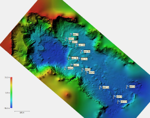
DTM (Digital Terrain Model) of the crater floor at White island
We were able to obtain images of the active crater area usually obscured by the gas and steam plume so we could make a new map and Digital Terrain Model (DTM) of the area. We know some of the crater floor was lowered about 13 m by the April eruption, but didn’t have any data on the vent area. During our visit in December we had a light easterly wind blowing the plume away from us and the humidity was low so the amount of steam was also low. Perfect conditions for flying the UAV mission over and in the crater.
Our UAV technician has processed the images and video captured on the day and is now compiling the DTM and surface maps. They are really impressive and are giving us a new insight to the changes within the active crater. No word yet on what Dino thinks of this new visitor to the island.