
New Zealand's 'silent earthquakes' of 2013
For those of us in the middle of the country, it was hard to miss that mid-2013 to early 2014 was an especially active period when it came to earthquakes.
It kicked off in July 2013 with the Cook Strait sequence – which included magnitude 6.0, 6.5, and 6.6 earthquakes – followed by the magnitude 6.2 Eketahuna earthquake in January 2014, and the magnitude 5.2 Waipukurau quake in March 2014.
2013 was also an especially active time for ‘silent earthquakes’, also called slow-slip events, which are similar to earthquakes as they involve fault movement. However, unlike earthquakes which occur in a matter of seconds, slow-slip events happen over weeks to months. In the last decade, slow-slip events have been discovered at plate boundaries around the world and GeoNet’s continuously operating GPS network in New Zealand has enabled the detection of slow-slip events at the North Island's Hikurangi subduction zone.
Last year four slow-slip events occurred around the North Island, including the largest slow-slip event ever recorded in New Zealand - it was offshore from the Kapiti Coast and equivalent to a magnitude 7.1 earthquake. A slow-slip event in Hawke’s Bay, equivalent to a magnitude 7.0 earthquake, was the largest on record for that region. Just like earthquakes, slow-slip events release strain, but without our GPS instruments, slow-slip events would be unreported as they can’t be felt and do not noticeably deform the ground. Nevertheless, the altered stresses around a slow-slip event can impact shallower faults that break via traditional earthquakes.
The extent to which recent slow-slip activity is related to the recent large earthquakes (and vice versa) is an area of active research, as we learn more about these relatively new phenomena (see below).
Exactly what is an slow-slip event? Read this article
The slow-slip events of 2013
Kapiti
The Kapiti event started in early 2013 and is still going on. It is New Zealand’s largest slow-slip event ever recorded, equivalent to a magnitude 7.1 earthquake. We have 12 years of records in this region, which show three Kapiti events, each occurring roughly every five years. So far, this current event has as much as 25cm of movement over an area approximately 100km by 200km. The previous event in 2008 was equivalent to a magnitude 7.0 earthquake, but the movement was more concentrated: 30cm of movement over a smaller area near Kapiti Island. The 2013 slow-slip event evolved over the course of the year, moving north-eastward towards the North Island, with movement diminishing in late 2013-early 2014.
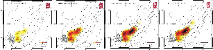
The Kapiti slow-slip event broken down into four time periods. The slow slip migrates toward Levin over time, while the period between July and Sept 2013 is the most active.
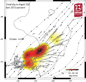
The overall slip of the 2013 Kapiti slow-slip event from January 2013 to the present. All slow-slip images in this story are made by Laura Wallace of the University of Texas at Austin (formally from GNS Science) using GeoNet GPS data.
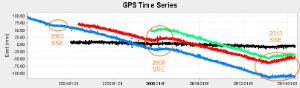
Horizontal land movement recorded on four GPS stations (station locations are shown on the map). The 2003, 2008, and 2013 slow-slip events are visible on the three coloured stations, but the slow-slip does not affect Golden Bay as it is too far west.

Map of four GeoNet GPS stations shown in the time series above
Hawke’s Bay
In February 2013, Hawke’s Bay experienced the largest slow-slip event for the region in a decade of recording. This slow-slip event occurred over several days and was the equivalent to a magnitude 7.0 earthquake. It was also associated with a swarm of over 100 earthquakes larger than magnitude 3 recorded during the period of slow slip, with the largest being of magnitude 4.8. These earthquakes occurred over a period of hours, and migrated deeper over time.
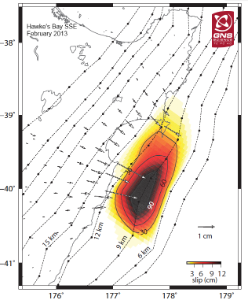
The February 2013 slow-slip event in the Hawke's Bay.
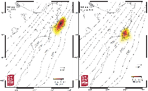
The July and October 2013 slow-slip events offshore of Gisborne.
Gisborne
Two slow-slip events were recorded in the Gisborne region in 2013: one in July, the other in October. Both events were smaller than the Kapiti and Hawke’s Bay slow-slip events. The July slow-slip event occurred to the northeast of Gisborne, whereas the October event occurred to the south. The amount of movement and exact location of these events are not precisely known yet, but a temporary deployment of sensors on the ocean bottom placed offshore from Gisborne are being retrieved this week, and these should have captured how these events deformed the seafloor above. While these sensors are being retrieved, a larger set of ocean bottom pressure sensors and seismometers are being deployed as part of a joint NZ/USA/Japan project. These will offer our best insight yet into Gisborne slow-slip events - read a blog of the deployment here.
The relationship between slow-slip events and earthquakes
There are several examples from both New Zealand and overseas of earthquake swarms accompanying slow-slip events. Because slow-slip events occur over a large area, the amount of stress they transfer to other faults is diffuse. This is unlike a large traditional earthquake that has a large stress transfer concentrated in a relatively small region. For this reason, a magnitude 7.1 slow-slip event is probably not going to have anywhere near the associated triggered earthquake activity that we saw after the magnitude 7.1 Darfield earthquake, but it will increase stress in surrounding areas, and could push an already stressed fault closer to rupture. In essence, it can be the straw that breaks the camel’s back. This is possibly what happened with the January 2014 Eketahuna quake, where the Kapiti slow-slip event loaded stress on the fault that broke. The fault in the Eketahuna earthquake would most likely have ruptured in the near future, but the added stress may have caused it to rupture earlier.
It is important to note a few caveats when looking at the transferred stress events from slow-slip events (or regular earthquakes):
Slow-slip events do not universally increase stress on surrounding faults, they also relieve stress in some areas, and therefore may postpone an earthquake in an area of decreased stress.
As we can’t directly measure the plate movement (because it is well below the surface and most often offshore) we have to use models to determine what is going on and how the stress is being distributed. As such, the model will hopefully give a good indication, but will not be perfect, as there are many details that we cannot resolve using solely land-based instruments.
Why we care when slow slip causes no shaking
Before discovering slow-slip events, earthquakes were thought to be the only way the Earth’s crust could relieve the pent-up stresses caused by the moving tectonic plates. With the discovery of slow-slip events, this thinking has been drastically altered, as slow-slip events accommodate a large proportion of the effects of the converging plates without knocking a single ornament off a shelf. Slow-slip events in themselves don't pose any risk to people, but they are a major part of how the tectonic plates move in a subduction zone. The other major part is earthquakes. So if we better understand the slow-slip events, we should better understand the earthquake potential of subduction zones.
The subduction zones where slow-slip events occur (in our case where the Pacific and Australian plates meet) are responsible for generating the world’s largest earthquakes – ‘great earthquakes’ or ‘mega-thrust earthquakes’ – which have a magnitude greater than 8. These types of earthquakes can also produce tsunami with deadly consequences as we’ve seen in recent times in Japan and Sumatra. Scientists think that a future mega-thrust earthquake with a magnitude of 8 or larger is possible on New Zealand’s northern subduction zone – the Hikurangi subduction zone. An earthquake this large would produce damaging shaking for much of the North Island, and could produce a significant tsunami affecting much of the country (and also some coastal regions around the Pacific). However, scientists still don’t know how much, and how often, the Hikurangi subduction zone ruptures in megathrust quakes. The best evidence at the moment suggests they are relatively rare, happening every 1500 years. This is an area of active scientific research in New Zealand, and the more we know about the slow-slip events, the more we understand the subduction zone as a whole, and ultimately the better prepared we, and other nations, can be.