2023 in Review
We take a quick look back at the happenings and highlights at GeoNet.
View our Infographic as a PDF here:
Earthquakes:
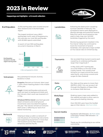
21,300 earthquakes were located around New Zealand and in the Kermadec region. The largest (onshore) was a M6.0 earthquake north-west of Paraparaumu, this was also our most felt earthquake with 60,688 reports submitted.
A swarm of over 900 earthquakes occurred in Kawerau in March.
Landslides:
Following the destruction caused by Cyclone Gabrielle in February, five surveillance teams were deployed to identify damage and potential hazards. Data from aerial reconnaissance was used to help map over 140,000 landslides triggered by the event
Monitoring equipment installed in the Fox Glacier Valley has continued to track the movement of several landslides, and captured a large rockfall on Fox Glacier late on Christmas Day.
Tsunamis:
We recorded three tsunami events each caused by an undersea earthquake larger than magnitude 7.
In May a M7.7 earthquake occurred 400km to the east of the Loyalty Islands. This caused small tsunamis on coasts around the south-west Pacific, and strong currents and surges for New Zealand.
Volcanoes:
We published 16 Volcanic Activity Bulletins in 2023.
Ruapehu: Remains at Volcanic Alert Level 1, with a short heating phase in the middle of the year.
Taupō: Unrest earthquakes and ground uplift are back to background levels and the Volcanic Alert Level was lowered to 0 in May.
Whakaari/White Island: Low level gas and steam emissions and small ground movements were recorded throughout the year. The volcano remains at Volcanic Alert Level 2, reflecting our lack of on-island monitoring.
Network:
Helping to keep us safe is a network of over 9k pieces of monitoring instruments and supporting equipment in more than 700 locations across New Zealand, Antarctica and the Pacific.
Data:
Our data archive grew to more than 280TB in 2023. You can access it all through the Registry of Open Data on Amazon Web Services.
Web/App:
Shaking Layers maps were added to the website and app to allow users to view ground shaking intensity.
Over 292,000 users have the GeoNet app on their device (+32k from 2022).
Social Media:
Facebook: 143k followers (+5k from 2022). X (formerly Twitter): 99k followers (+2k from 2022).
Thank you for contributing to our online community.
Earthquakes can occur anywhere in New Zealand at any time. In the event of a large earthquake: Drop, Cover and Hold.
Remember Long or Strong, Get Gone : If you are near the coast and feel a strong earthquake that makes it hard to stand up OR a weak rolling earthquake that lasts a minute or more move immediately to the nearest high ground or as far inland as you can, out of tsunami evacuation zones.
Know what to do?
The National Emergency Management Agency (NEMA) has a great website with information on what to do before, during and after an earthquake.
Prepare your home. Protect your whānau.
There’s a lot we can do to make our homes safer and stronger for natural hazards. Toka Tū Ake EQC’s website has key steps to get you started.
Media Contact: 021 574 541 or media@gns.cri.nz

