Keeping tabs on ‘silent’ earthquakes
We’ve been tracking a slow-slip event (or ‘silent’ earthquake) in the Hawke's Bay region since the beginning of May. Our instruments have measured approximately 2 cm of eastward motion over the past two weeks. To put this in perspective, 2 cm represents approximately six months worth of plate motion in only two weeks.
Unlike ‘usual earthquakes’, slow-slip events unfold over weeks or months rather than seconds. As this release of energy takes place slowly, it doesn’t cause shaking that is felt by people, or even by our seismographs. Instead, it is our continuously operating Global Navigation Satellite System (GNSS) stations (commonly referred to as GPS) that track millimeter-level movement of the land on a daily basis, that allow us to see events like this unfold.
Slow-slip events themselves don't pose a risk to people, but they are a major part of our growing understanding of how tectonic plates move in a subduction zone. If we can better understand slow-slip events, we can better understand the earthquake potential of subduction zones.
Slow-slip events are a good reminder that we live on a very active tectonic plate boundary. The best thing you can do now is refresh yourself on earthquake preparedness information, you can find some links at the bottom of this page. Our team will continue to keep an eye on this slow slip activity, and we will keep you updated as new data comes in.
Keep reading to learn more about slow-slip earthquakes
When slow-slip events occur, they relieve a lot of pent-up stress on the subduction plate boundary. At the same time, they can increase stress on other nearby portions of the plate boundary. So, they are occasionally accompanied by an increase in smaller earthquakes that may be felt by the public.
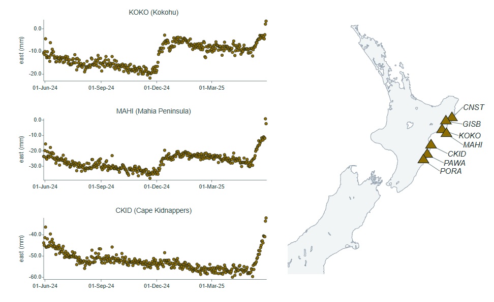
Slow slip watch page showing changes in the east-west position with time at GeoNet’s GNSS stations in central Hawke’s Bay. The “upward” turn on the right-hand side shows the eastward movement of sites in that area since the beginning of May.
Since the beginning of May, we have located more than 100 earthquakes in the central Hawke’s Bay region, with the largest so far being a M3.1 recorded on Saturday, 17th of May.
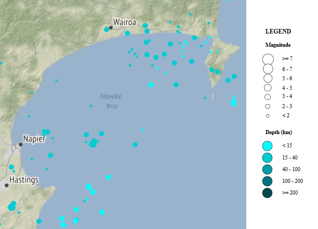
Map of recent earthquakes in the Hawke’s Bay region since 1 May 2025
We often see slow-slip events in the Gisborne and Hawke's Bay area. The most recent was reported in December last year offshore the Gisborne region, between Mahia Peninsula and Tolaga Bay – that lasted about a month.
This time our GNSS stations picked up a slow-slip event offshore the Hawke’s Bay region, between Cape Kidnappers and Mahia Peninsula. The GNSS stations in the Mahia Peninsula, which is located between the two slow-slip events, have picked up both December and May ‘silent earthquakes’.
Based on our observations of past Hawkes Bay slow-slip events, this one is likely to continue for the next few weeks.
Data display refresh
Behind the scenes we have been improving the generation and visualisation of GNSS data. You can now view GNSS data in our refreshed “Geodetic” data page or have a close look at the stations measuring the most recent slow-slip events following this link.
Helping us understand this area
There are a number of scientific research projects that GeoNet engages with, that specifically focus on trying to better understand this important plate boundary fault, such as the GNS-led PULSE project (Physical processes UnderLying Slow Earthquakes). With major collaboration and contributions from international partners, PULSE has given scientists a better understanding of the way plate tectonic stresses builds up and dissipate on the Hikurangi subduction zone.
Read: The PULSE Project
Watch: What is a Slow Slip Earthquake
View: Slow Slip Watch Page
In the event of a large earthquake: Drop, Cover and Hold.
Remember Long or Strong, Get Gone: If you are near the coast, or a lake, and feel a strong earthquake that makes it hard to stand up OR a weak rolling earthquake that lasts a minute or more move immediately to the nearest high ground or as far inland as you can, out of tsunami evacuation zones.
The National Emergency Management Agency (NEMA) has a great website with information on what to do before, during and after an earthquake: Get Ready website.
Prepare your home. Protect your whānau.
There’s a lot we can do to make our homes safer and stronger for natural hazards. Check out the Natural Hazards Commission website on how to get your home, apartment, or rental prepared for a natural disaster.