Exciting updates to our website
We made some exciting changes to our website today, 1 November 2022, with some new data as well as some layout changes that you may have noticed when visiting. We go through them all below.
What are the changes?
The GeoNet website navigation has been updated so our data pages are now easier to find. It also makes it easy for us to add new data products and group similar pages in the future.
There are now three data tabs:
- Data Discovery - here you can access to GeoNet’s interactive web tools that allow for data visualisations and searches,
- Data Types - information on the variety of GeoNet’s data types
- Data Access - for technical details on GeoNet’s data services, Application Programming Interfaces (APIs) and data tutorials.
The navigation has been rearranged to help GeoNet’s data users easily find what they are looking for.
The GeoNet News link has also moved to the top menu of the home page, also making it easier to find.
New Data Access Tool
The addition of a modern data access and exploration tool for GeoNet time series data is another exciting new feature.
The new Tilde Time Series API is intended to become the “one stop shop” for users to access all GeoNet’s time-series data that are collected at a sample rate of 1 second or longer. Tilde allows data users to easily explore and discover available data and provides help with programmatic access to our technical users.
Tilde currently provide access to DART (Deep-ocean Assessment and Reporting of Tsunami) and envirosensor data (collected by our new Low-Rate Data Collection Platform).
More datasets and migrations are planned in the future.
Tilde exploration tool, API documentation and tutorials can be found navigating the new data tabs.
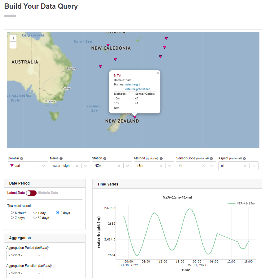
DART data visualised via the Tilde Time Series Data Discovery GUI
AWS Open Data
GeoNet data is now available via the Amazon Web Services (AWS) Open Data Program. GNS Science is the first NZ based organisation to use the Amazon Web Services (AWS) Open Data Sponsorship Program(external link) to achieve this, which means that for the first time, GeoNet’s entire archive is available to download, and in an instant.
Making data freely available to researchers has been an underpinning philosophy of GeoNet since our inception in 2001. Now, our datasets are faster to download, especially for large dataset requests, and more accessible to researchers, learning institutions, and the general public globally via the Registry of Open Data on AWS(external link), which exists to help people discover and share data. Data access via the AWS Open Data Program supplements existing data access mechanisms.
"Being part of the AWS Open Data Sponsorship Program is a great opportunity for us to step boldly forward, supporting research that could have wide ranging dividends, like training algorithms to detect currently unknown trends that could potentially predict future events,” said Dr Jonathan Hanson, GeoNet Data Manager, GNS Science.
All three changes together are part of GeoNet evolving to help data users take full advantage of our data and looking to future data user needs though improving its access and findability and enabling big data research. We hope you enjoy them.
Media Contact: 021 574541 or media@gns.cri.nz