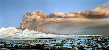
Comprehensive volcanic activity records are now available online for Ruapehu and Tongariro volcanoes
Two extensive catalogues of historic volcanic activity covering observed volcanic activity since the 1830s at Ruapehu and Tongariro have been compiled by GNS Science.
Where to access the data
GeoNet has recently added these volcanic activity catalogues to its growing collection available via one of GeoNet’s GitHub repositories that caters for small data sets (these are data sets that are updated on an irregular or infrequent basis). The files are in CSV format, so are easy to use by everyone. These online digital data sets sit alongside the lengthy science reports that document how the data were collected and its limitations. Reports and observations on volcanic activity form part of GeoNet’s hazard products and complement the recently available historic Volcanic Alert Level data set.
GNS Science – Ruapehu Science Report
GNS Science – Tongariro Science Report
Who uses this data?
To estimate risk, volcano researchers need to know how often, how big and where volcanic activity occurs. For example, they consider ‘do eruptions occur at regular intervals?’, or ‘do they occur in clusters separated by long periods of inactivity’? A record of eruptions derived by examining the deposits left in the landscape by volcanic activity can help estimate the long-term rate of activity. By itself though, this record may not include smaller eruptions that are still large enough to have social and economic impacts on our society, such as the 1995-96 eruptions at Ruapehu. This is where a catalogue of historic activity is valuable, especially when it can be related to impacts on society.
Findings from the catalogues
Ruapehu was very active in 1895, 1910, 1944-1946, 1982, 1987-1990 and 1995-1996. Since the 1995-96 eruptions, there has only been two eruptions. The period from 1964 to 1995 was marked by near constant high levels of volcanic unrest and numerous small eruptions. A feature of the Ruapehu catalogue is that a size estimate is available for each eruption, which is useful for helping to estimate past impacts.
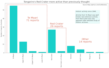
The Tongariro catalogue highlights that historic volcanic activity has originated from several vents on the Tongariro massif. Vents at Te Maari were known to have been repeatedly active, but the real surprise in the catalogue is how active the Red Crater area was, especially in the late-1800s.
The catalogues were compiled after a painstaking analysis of datasets like old newspapers, parliamentary records as well as published and unpublished scientific reports. The Ruapehu data set, with over 600 observations, shows that the activity is strongly clustered.
For inquiries about accessing and using the data please email the team at info@geonet.org.nz.
New Zealand has several active volcanoes and volcanic fields that could erupt without warning. We monitor all our active volcanoes for signs of activity and provide updates of activity via Volcanic Alert Bulletins if there are any significant changes to report. To read more about being prepared for volcanic activity visit the National Emergency Management Agency’s (NEMA’s) website, getready.govt.nz.
Attributable to: Brad Scott – Volcano Information Specialist
Media Contact: 021 574 541 or media@gns.cri.nz


