2022 Manawatū and Hawke’s Bay slow-slip activity
Two slow-motion earthquakes have been taking place so far in 2022 under the central and eastern North Island. These events are like earthquakes in slow motion, unfolding over weeks to months and cannot be felt by humans. Read on to find out more about these events.
In late 2021, we reported that a deep slow-slip event had begun beneath Kāpiti in the lower North Island. Since the beginning of 2022, that slow-slip event has travelled north beneath Manawatū. A few weeks ago, scientists also began to record a second slow-slip event off the shore of Hawke’s Bay. The Hawke’s Bay event now appears to be over.
The Hikurangi subduction zone – the boundary between the Australian and Pacific Plates – extends along the east coast and dives westward underneath the North Island. We frequently have slow-slip events on the shallower part of the subduction zone off the east coast. The short-lived event that just wrapped up in Hawke’s Bay is a good example but this year, the deeper portion of the plate boundary beneath the Manawatū area has been slowly slipping too.
The Manawatū slow-slip event
We last recorded a slow slip in the Manawatū area about six years ago. Given they typically happen about every 5 years or so, our scientists have been expecting this event to happen.
Some 30-50 kilometres beneath Manawatū, the Pacific Plate started moving slowly again in January after being ‘stuck’ to the overlying Australian Plate. Although the Manawatū event appears to be slowing down somewhat, based on previous slow-slip events there, scientists say that it could continue off-and-on for the rest of 2022. We’ve been recording the movement at GeoNet’s GPS network sites in the Manawatū area.
So far about 15 cm of movement along the subduction zone plate boundary beneath the central North Island has been recorded. We’d typically see 3.5 cm of movement there each year, so this is over four years’ movement in just seven months. The slip has also caused up to 2-3 cm of surface movement (mostly eastward and upward) of GeoNet GPS sites above the slip. Interestingly, this amount of movement over the past six months is equivalent to what could happen in a M6.9 earthquake.
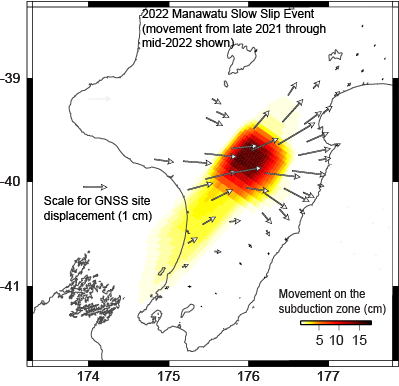
Model showing the amount of movement on the Hikurangi subduction zone under Kāpiti-Manawatū since December 2021, in centimetres. The arrows show displacement of GeoNet continuous GPS sites used to detect the slow-motion earthquake.
The Hawke’s Bay slow-slip event
The short-lived Hawke’s Bay slow-slip event that started in late June 2022 appears to have finished up in mid-July. It caused up to 2 cm of displacement at some GPS sites along the east coast of the North Island above the subduction zone. This is indicative of more than 7 cm of movement on the subduction zone offshore beneath Hawke Bay. The movement on the plate boundary in this Hawke’s Bay slow-slip event is equivalent to a M6.8 earthquake.
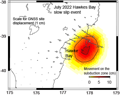
Model showing the amount of movement on the Hikurangi subduction zone under Hawke Bay since late-June 2022, in centimetres. The arrows show displacement of GeoNet continuous GPS sites used to detect the slow-motion earthquake.
Combined, this year's Hawke’s Bay and Manawatū slow-slip events have involved total movement on the Hikurangi subduction zone equivalent to a M7 earthquake.
It’s possible that the Manawatū slow-slip event caused stress changes on the plate boundary which led to the Hawke’s Bay slow slip event. We have observed this in the past, when a similar sequence of deep (Manawatū) and shallow (Hawke’s Bay) slow-slip events occurred simultaneously in 2011 and 2015.
Why do we have slow-slip events in New Zealand?
Slow-slip events occur where one tectonic plate subducts beneath another. Indeed, we now realise that they are a common occurrence at these types of plate boundaries. During the months to years between slow-slip events, the plates are “locked” together due to friction on the fault. Then, during the slow-slip events the plates start slipping past each other for days to months and relieve the built-up tectonic stress that was accumulated when the plates were locked together. The reason that slow-slip events occur in some locations along the Hikurangi subduction zone is most likely related to the properties of the rocks where they occur, and the presence of water in the subduction zone.
How common are they here?
Slow-slip events are common in New Zealand, and we’ve recorded dozens of them since 2002. This is when we partnered with Toitū Te Whenua Land Information New Zealand to install a GPS network around the country.
Do slow-slip events occur all along New Zealand’s plate boundary?
No, they don’t. For example, beneath the Wellington and Wairarapa regions the plates have been locked together for a very long time — probably hundreds of years. The stress that is building-up between the locked plates will eventually be relieved by a large earthquake sometime in the future.
Why can’t we feel slow-slip events?
Slow-slip events can be a little tricky to get your head around. During a slow-slip event, the plates are slipping past each other along the subduction zone faster than they normally do, but still much, much slower than a normal earthquake. Slow-slip events can involve the same amount of movement on the plate boundary as a magnitude 7 earthquake, but they are occurring so slowly (and releasing seismic energy very slowly) that no one would know. They result in a lot of tectonic plate motion in New Zealand that would otherwise build up stress. They can also produce some local earthquakes that we can record on our seismometer network.
If you can’t feel them, how do we record them?
We measure and record slow-slip events by looking at GPS data to see how the land is moving. These are the one type of earthquake you can’t measure with a seismometer! You can view this GPS data on our slow-slip watch or geodetic data pages to see when these events are happening. When the plots start moving in the opposite direction to the normal trend – in this case, when the GPS points start moving east (or “upward” on the plot) – that’s when a slow-slip event is underway.
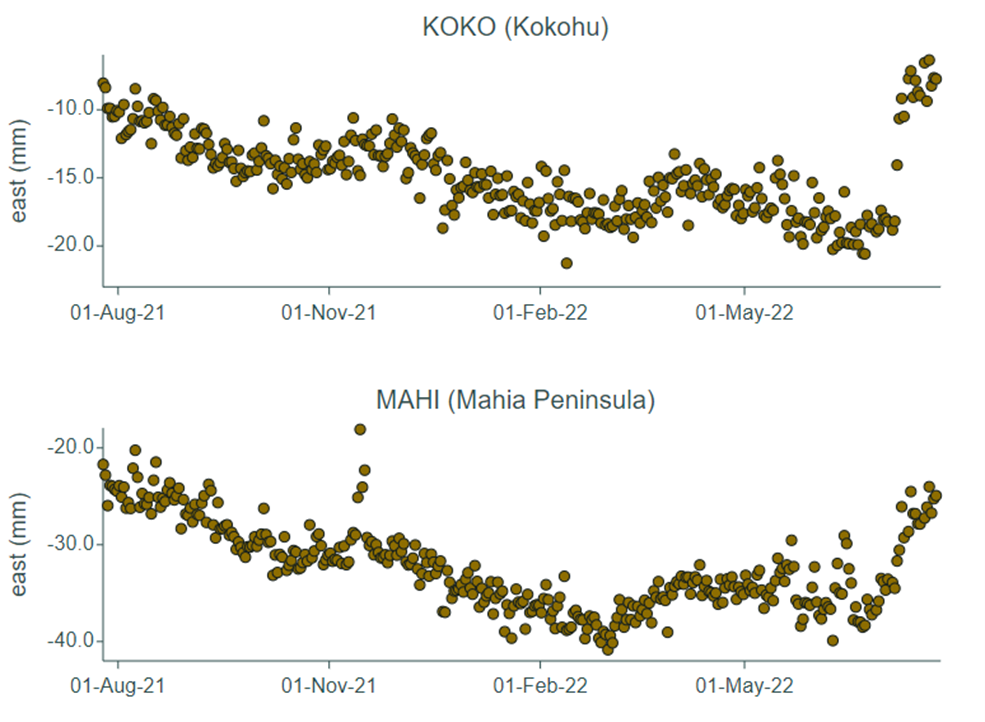
GPS site plots on our Hikurangi slow slip watch page – upward trending plots show eastward movement indicating a slow-slip event is underway.
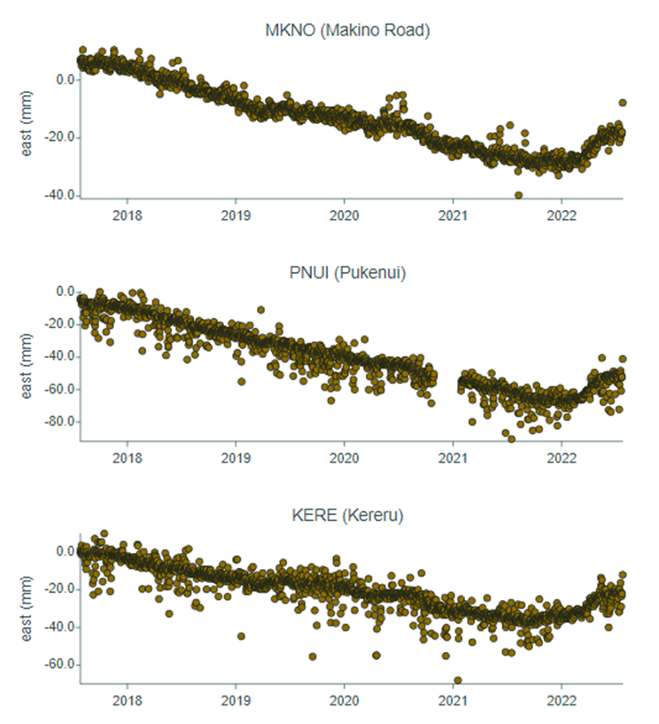
Slow slip visible on Manawatū GPS sites.
What can you do?
We will continue to provide updates on slow-slip activity in New Zealand.
Slow-slip events are a great reminder that we live on a very active tectonic plate boundary here in New Zealand.
If you feel an earthquake: Drop, Cover and Hold. If you are near the coast and you feel a Long OR Strong earthquake, get to higher ground or as far inland as possible once the shaking has stopped in case a tsunami was generated. For more information on how to get you and your whānau prepared, visit the National Emergency Management Agency’s website getready.govt.nz.
For information on how to prepare your house for earthquakes, check out Toka Tū Ake EQC’s advice for homeowners and renters.
Attributable to: Laura Wallace – GNS Science Geophysicist
Media enquiries: media@gns.cri.nz or 021 574 541