
One year on from the Kaikōura earthquake and tsunami
The shadow of the Kaikōura earthquake and tsunami has dominated our year here at GeoNet. I feel for the many people dealing with the consequences in the region of the earthquake, from Waiau all the way up the east coast to Seddon and Ward.
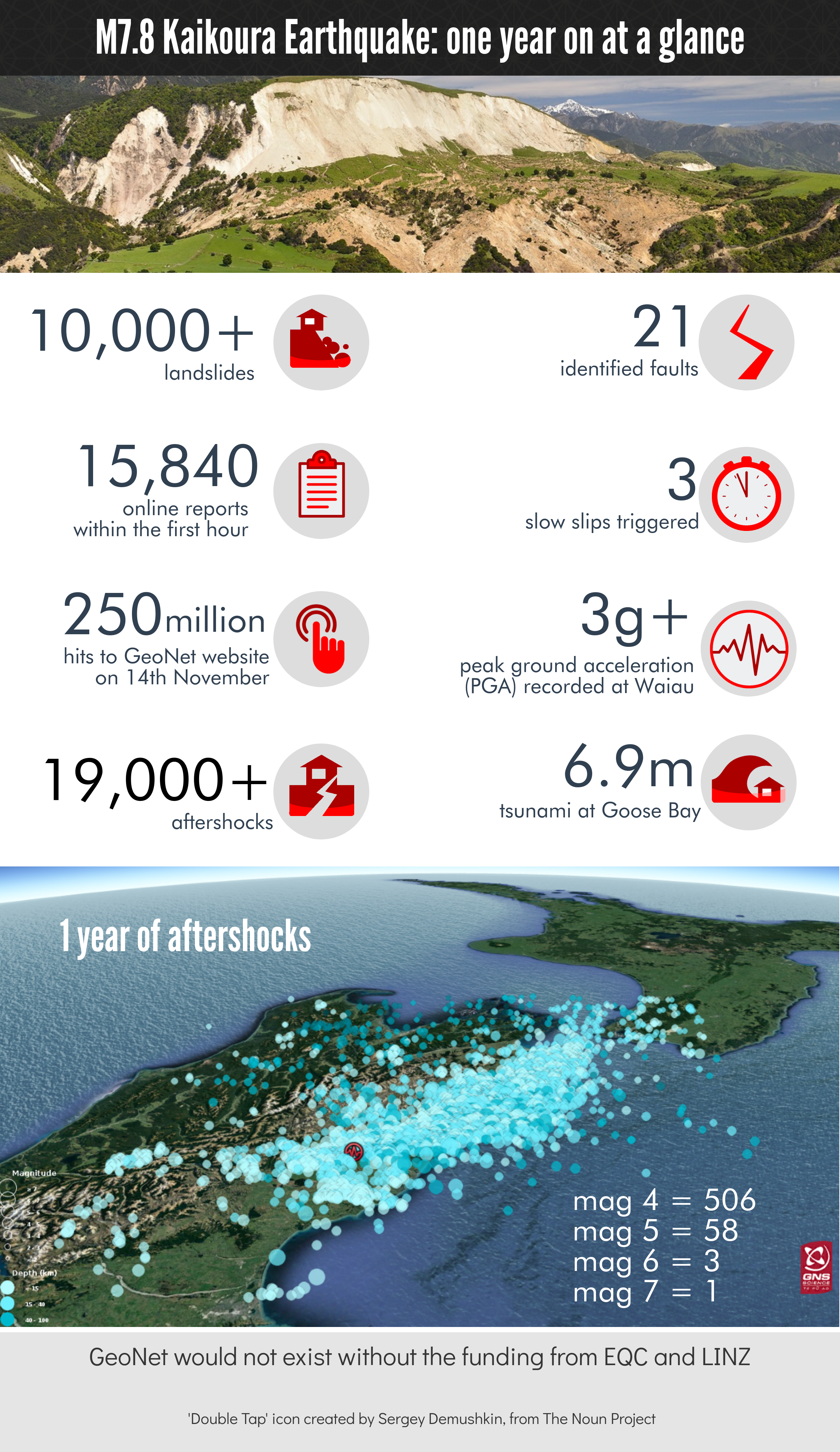
The 22 October M5.6 earthquake near Kaikōura was an unwelcome reminder that the Earth itself is still coming to terms with the destruction on this day last November. That earthquake is one of almost 20,000 aftershocks we have located since the first mammoth shake.
The changes caused by the monster earthquake on the landscape are extreme. Geologists have identified 21 faults that moved in the two minutes or so following the beginning of the rupturing near Waiau until the action stopped at the top of the South Island. The amazing levels of shaking at both ends of the rupture demonstrate the destructive power. Uplifts of metres have changed that coastline forever.
Events like the Kaikōura earthquake and tsunami change individuals and organisations. So how has GeoNet changed? For a start, we now take local-source tsunami very seriously. We always knew they could happen, but our procedures for regional and distant tsunami were more developed. Local tsunami remained a “blind spot” because of the very fast response times required. This is an international as well as New Zealand issue. A tsunami wave can be onshore before warnings can be issued – particularly for those who live near the sea in active regions like the east coast of the North Island. The Kaikōura earthquake caused tsunami run-up of almost 7 metres in some locations - for an earthquake which started on land!
With local-source tsunami the message will always be - “if an earthquake is long or strong, get gone” – meaning if you feel a strong earthquake or one that goes on for a long time, move quickly way from the sea and to higher ground. To support the Ministry of Civil Defence and Emergency Management (MCDEM) in the process of getting warning messages out quickly, we have developed and are developing new procedures and tools to identify tsunami threats.
Just before Christmas last year the Government announced funding to improve the GeoNet response capability, repair the Kermadec DART Buoy and investigate the move to 24/7 operations. The Kermadec DART Buoy was repaired in September in a joint project between the US owners (NOAA), GNS Science and NIWA. We are now in the planning stage for the implementation of a GeoNet operations centre – watch this space.
On a personal note, I have been seconded to work full time on the project to plan and implement enhanced geohazards monitoring as a part of what we are calling GeoNet 2.0. Up to now GeoNet has been fundamentally a data collection and monitoring platform for New Zealand’s geological activity, with funding from the Earthquake Commission and Land Information New Zealand. We have some capability to notify via the website and App when events occur, and to advise MCDEM. But until now notification has not been our primary role. We are excited about taking GeoNet to the next level adding faster and more consistent notifications of events whenever they happen (working very closely with MCDEM), while continuing to do what we currently do well.
Dr Ken Gledhill Technical Advisor, GeoNet 2.0 Project (seconded from the GeoNet Director Role)
The M7.8 Kaikoura earthquake - one year on
We can’t stop tsunamis from happening BUT we can prepare for them. Want to know how? Here are some great places to go to get more information about New Zealand and preparing for tsunamis: - Ministry of Civil Defence and Emergency Management - EQC - Get Ready Get Thru - Also, visit your local or regional council for tsunami evacuation maps.