National Advisory: Tsunami activity – expect strong and unusual currents and unpredictable surges at the shore following the M8.7 earthquake, Kamchatka Russia. For all information please visit NEMA (The National Emergency Management Agency) Only messages issued by NEMA represent the official warning status for New Zealand.
Improved monitoring at Mt Ruapehu
Our volcano monitoring group uses three primary data sets to effectively monitor active volcanoes: seismic (earthquakes), ground deformation and water-gas chemistry. The team recently completed the installation of a network of continuous gas emission detectors, tuned to detect SO₂ (sulphur dioxide) gas around Ruapehu volcano, which allows us to monitor the amount of SO₂ the volcano produces.
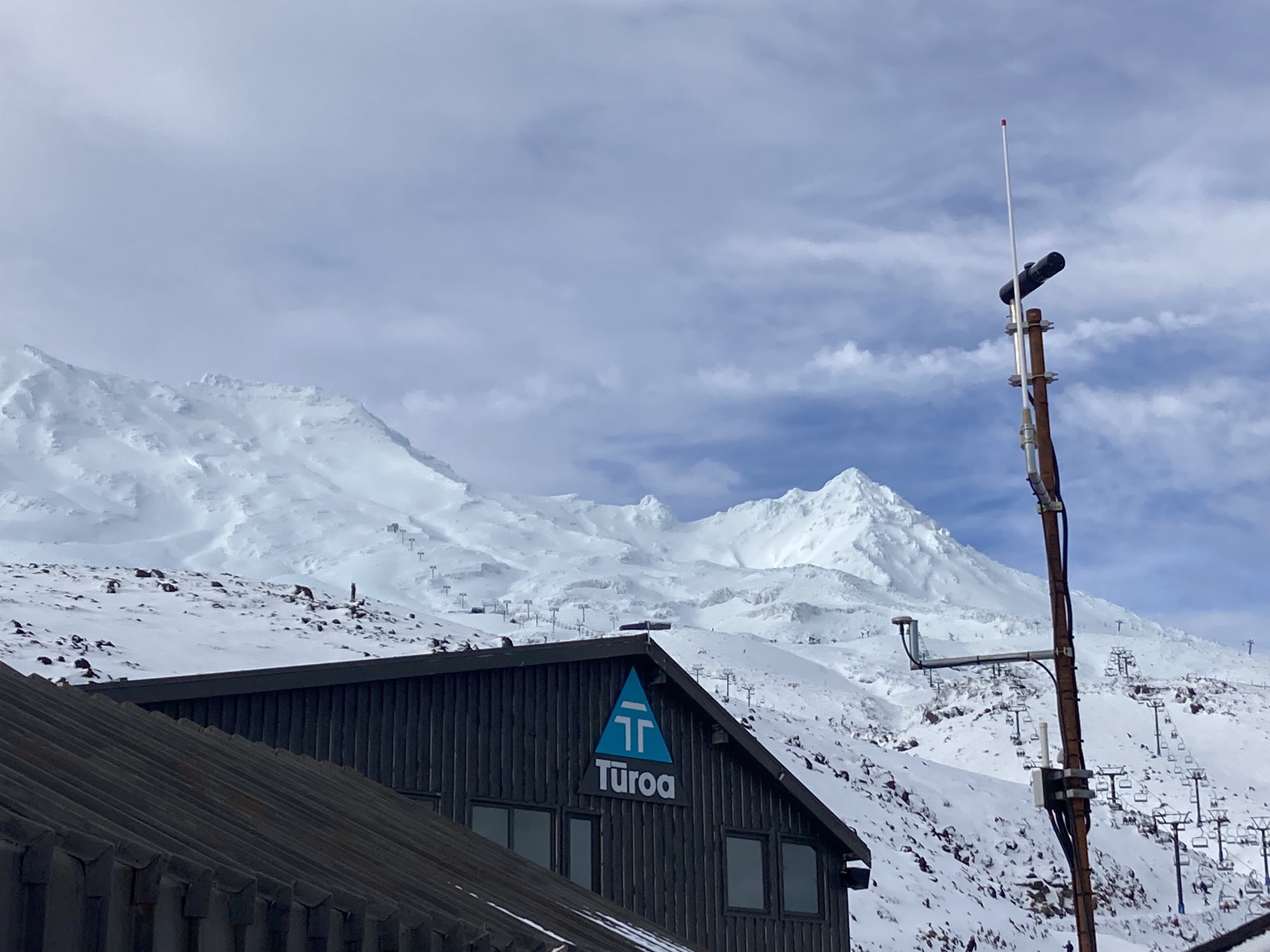
The south-western DOAS scanner at Turoa ski field detects the SO2 plume from Ruapehu when the wind is blowing from the north-east quarter. The scanner is the black footlong tube at the top of pole.
We have now deployed three sensors around Ruapehu volcano with support from the Department of Conservation, Ruapehu Alpine Lifts and local Iwi. The sensor technology is based on differential optical absorption spectrometry (DOAS).
The ScanDOAS sensors measure the absorption of the ultraviolet light from the sun by monitoring the SO₂ gas present in the volcanic plume produced at a volcano. To operate effectively the volcanic plume must pass over the sensor and the sky needs to be clear. To achieve this, we have deployed the three sensors, shown in the image below, to cover as much of the downwind areas as we can. These sensors have been invaluable to the monitoring efforts at other active volcanoes since 2012 and will complement the monthly aerial surveys we conduct at Ruapehu.
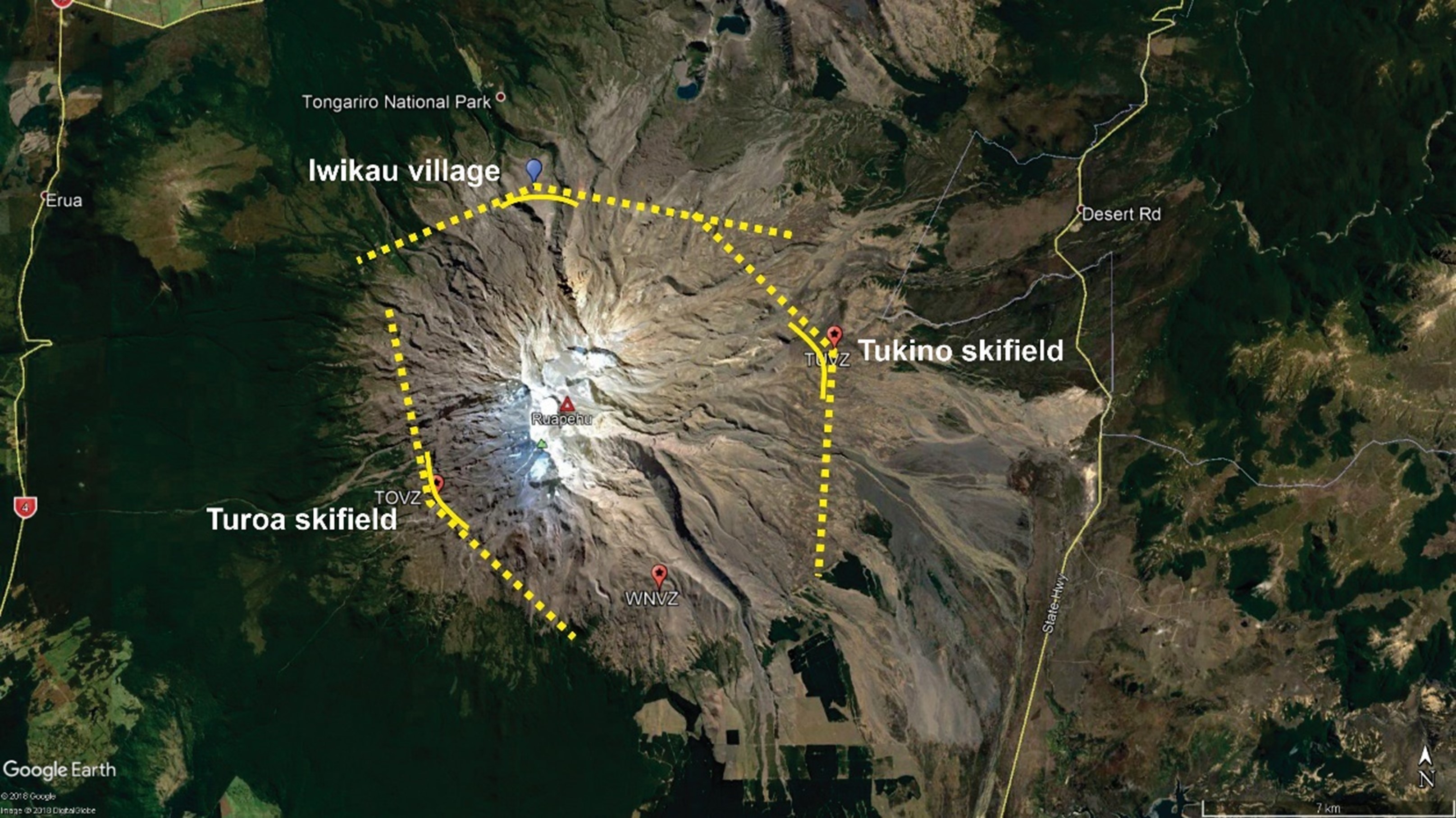
Aerial image showing location of the sensors on Mt Ruapehu.
Why do we monitor volcanic gas?
Active volcanoes produce a lot of volcanic gas. The most common is water/steam (H₂0) and others include CO₂ (carbon dioxide), SO₂ (sulphur dioxide), H₂S (hydrogen sulphide), H₂ (hydrogen), CO (carbon monoxide), HCl (hydrogen chloride) and CH4 (methane). Each of the gases tells us a part of the story about the processes within the volcano.
We target SO₂ and CO₂ as they come directly from the molten material (magma) within a volcano on a regular basis. Changes in the amount of gas, and the flux rate or the ratios between the gases can indicate a change taking place within a volcano. These, coupled with seismic and deformation data, help us monitor the status of the volcano and set the Volcanic Alert Level.
The gas plume is usually transparent and cannot be seen by the naked eye. The energy from the sun has variable intensity across many wavelengths (red line below). As the scanners look up and across the volcanic plume (grey area) they search for the wavelength’s indicative of SO₂. We subsequently see a signal, as shown in the blue scan plot below. Making many scans per day we can build up a record of the gas flux occurring at the volcano throughout the daylight hours (green plot). We then use wind speed data to determine how much gas per day the volcano is discharging.
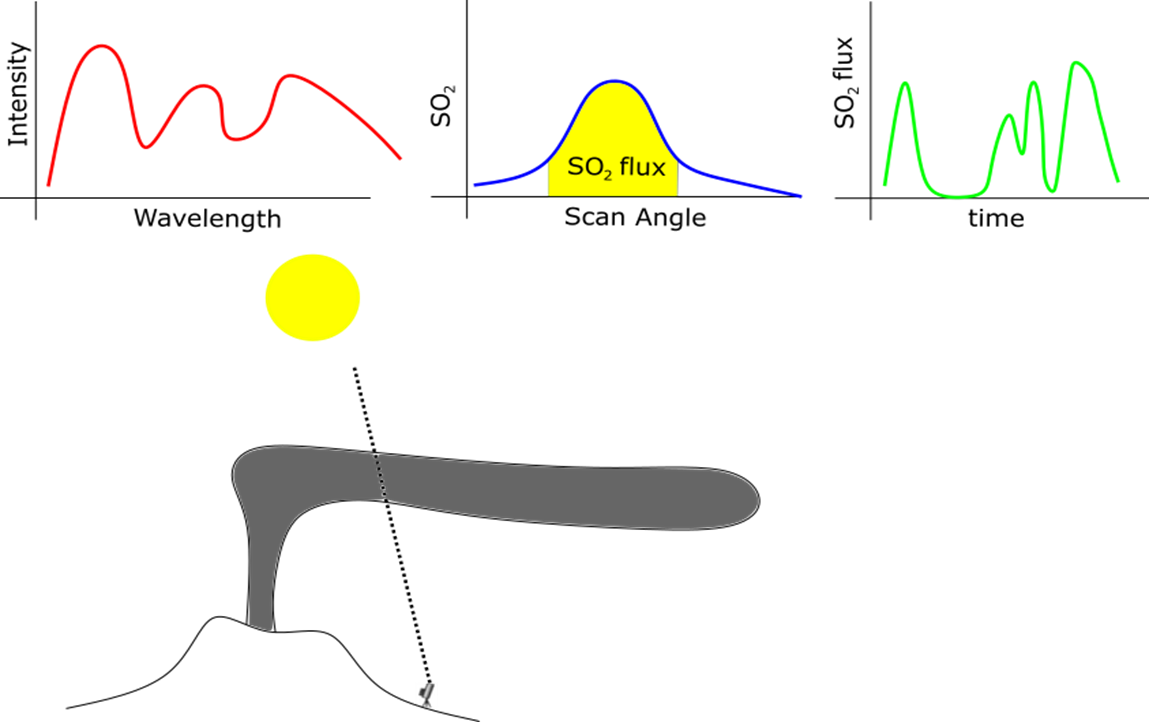
Schematic shows the intensity (red) of the signals from the sun, a SO2 scan (blue), the results over time (green) and the relationship of the scanner to the volcanic plume and sun.
Planning on visiting Mt Ruapehu?
Find out more about Mt Ruapehu and other New Zealand volcanoes here.
For information on access to the Mt Ruapehu area, please visit the Department of Conservation’s website on volcanic risk in Tongariro National Park and follow their Facebook page for further updates.
You can read all of our Volcanic Activity Bulletins here.
Although we can’t prevent natural hazards, we can prepare for them – and we should.
The National Emergency Management Agency's (NEMA) Get Ready website has information on what to do before, during and after volcanic activity.
During volcanic activity, follow official advice provided by your local Civil Defence Emergency Management Group, the Department of Conservation (for visitors to the Tongariro and Taranaki National Parks), local authorities and emergency services.
Prepare your home. Protect your whānau.
There’s a lot we can do to make our homes safer and stronger for earthquakes. Toka Tū Ake EQC’s website has key steps to get you started.
Media contact: 021 574 541 or media@gns.cri.nz