
Today marks the 10th anniversary of the 2011 Christchurch earthquake.
Ten years ago, at 12.51pm, on 22 February 2011, the city of Christchurch was struck by a magnitude 6.2 earthquake.
Still recovering from the effects of the magnitude 7.1 Darfield earthquake that had occurred six months prior, the people of Canterbury were once again thrown into scenes of devastation. While smaller in magnitude than the earlier September quake, this earthquake occurred on a fault line that was shallow and close to the city. This made the shaking in Christchurch particularly significant. The event caused widespread destruction and the tragic loss of 185 lives. Then and now, our thoughts are with those whose worlds were upturned by this earthquake – whether because of injury, damage, or the loss of loved ones.
Beneath the ground
The 22 February quake was caused by a fault that lies buried under the Port Hills, about 6km south of the city centre, along the edge of the city. The fault rupture was about 14km long and extended from Cashmere east-northeast to the Avon-Heathcote estuary area. It occurred on a ‘blind’ fault, which is buried beneath the sediments and has no obvious surface expression.
The fault rupture began as a small amount of slip between the two sides of the fault, about 6km below the ground. Over the next few seconds the rupture spread upwards and towards the northwest, with the amount of slip increasing as it the earthquake unfolded.
The direction of movement – up and towards the northwest – focused the energy of the earthquake towards Christchurch and helps to explain the significant damage that occurred in the city.
The rupture itself never reached the surface, terminating about 1km below within the thick sediments. Although we cannot see evidence of a fault break at the surface, we can detect the bending of the land either side of the fault through GPS and satellite imaging.
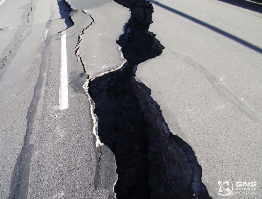
Road Damage Feb 2011
Movement of land on either side of the fault plane was a mixture of vertical horizontal motion. The land south of the fault slid up the fault surface by as much as 2.5m on the section of the fault near the Avon-Heathcote estuary. This process – called reverse faulting – raised part of the Port Hills and part of southern Christchurch.
The deeper and westernmost 5 to 6 kilometres of the fault slipped predominantly horizontally by a few tens of centimetres. On the northern side of the fault the land shifted eastward while the land to the south of the fault shifted westward.
On the surface
The ‘strong’ nature of the fault and its direction of movement combined to produce exceptionally strong ground motion. In the city centre, ground accelerations were three to four times greater than those produced by the September 2010 earthquake.
Liquefaction was also much more extensive than in the September 2010 earthquake. Shaking turned water saturated layers of sand and silt beneath the ground surface into sludge that squirted upwards through the cracks. Areas in the eastern part of the city that were built on a former swamp were particularly hard hit by liquefaction.
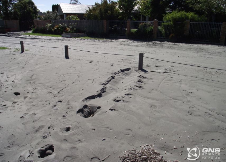
Liquifaction Feb 2011
The Port Hills suffered extensive damage due to rockfalls, land movement and cliff collapse. Following the quake, deep tension cracks and rents on slopes indicated areas with potential for further collapse.
At GNS Science and the GeoNet Programme
The science response that followed this quake and the earlier Canterbury events was transformative for GNS Science and the GeoNet Programme in a number of ways. It required a tremendous amount of hard work from all involved, and the experience brought about incredible advances in our science, our operations and the public awareness of our work.
The events showed us that in the wake of disaster, science information can bring comfort to people. Since then, we have made information more widely accessible and quickly available to everyone. With every large event that has occurred since February 2011, we have thought first about the people affected and how we can best communicate with them.
The Canterbury sequence was the first earthquake in New Zealand in which aftershock forecasting was used. For the first 18 months after the quake, there were weekly updates on the probabilities of aftershocks occurring. These figures are now updated annually. Aftershock forecasts have since been calculated for several major earthquakes since Christchurch. The probabilities are fed into new building standards, so that our buildings will be more resilient to earthquakes in the future, and they are also used by the insurance industry to compare risks from different hazards.
For insight into the impact of the Christchurch earthquake sequence here at the GeoNet Programme we sat down with some of our experts to hear their stories from the response. These interviews have resulted in 18 bite-sized videos that capture the stories from behind the science.
Click here to view all of the videos
Need to Talk? If you would like support or advice, have feelings of anxiety, stress, prolonged fear, hopelessness or anger, or if you just need to talk with someone. Please text or phone 1737 to speak to a trained councillor in the National Telehealth Service. Its free to call or text.