
Earthquakes in the Kermadecs – what you need to know
The Kermadec Islands region north of New Zealand is quite a seismically active place. Here’s more information about quakes in this region and what it means for you.
Why is the Kermadec region such an active area?
The Kermadec Trench extends from the Hikurangi Subduction Zone off the east coast about 1,300 km towards Tonga. Because it is almost continuous with the Tonga Subduction Zone, it is often referred to as the Tonga-Kermadec Subduction Zone. This trench is a subduction zone where the Pacific Plate is diving westwards under the Australian Plate, just like what is happening below the North Island.
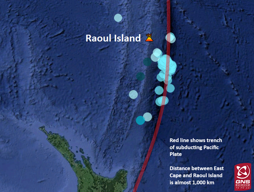
Location of Raoul Island in the Kermadec Islands and earthquakes over M5.0 in the last month (20 May – 20 June 2019). The subduction zone north of New Zealand is visible in red.
The region of the Sunday 16 June M7.0 earthquake is subducting faster than that of the Hikurangi Subduction Zone. It currently subducts about 60 mm each year, likely making the Kermadec Trench more active than the Hikurangi Subduction Zone.
What magnitude quake would generate a tsunami there? What kind of quake would be needed?
The Sunday 16 June earthquake did generate a very small tsunami at Raoul Island – about 0.1m at the two tsunami gauges operated by GeoNet on the Island. This is not large enough to be regarded as a threat. An earthquake in a similar location would probably need to be in the high M7s, close to M8, to produce a tsunami large enough to be a land threat to New Zealand.
Our magnitude for this quake is M7.0, however these events are outside the GeoNet network so our magnitude is less than the international agency estimates of around M7.2. We are planning to put out some information soon explaining what different magnitudes mean and why they often differ.
Which parts of the country would be most vulnerable to such a tsunami?
The most vulnerable parts of New Zealand would be the areas along the upper North Island nearest to the epicentre, i.e. parts of Northland/Auckland/Bay of Plenty/East Cape. If the earthquake is large enough, the entire coast of New Zealand would be variously affected by tsunami inundation.
How long would it take to arrive?
Travel time would be affected by the location of the earthquake. At the southern end of the Kermadec region, it could be less than an hour. If the quake originated further north, it could take about two hours for the first waves to hit the New Zealand coast.
Staying safe – what should we be aware of?
It is important to remember that in seismically active zones, large earthquakes can occur at any time. It is well known that earthquakes occurring in the Kermadec region have the potential to generate tsunamis.
Kermadec earthquakes are not likely to be strongly felt at all of New Zealand’s tsunami prone coastlines, so it’s important that people know the correct actions to take for a tsunami and how to stay informed - via radio, Emergency Mobile Alerts, social media, and the Ministry of Civil Defence & Emergency Management (MCDEM) website.
New Zealand’s entire coastline is at risk of tsunami inundation – it’s part of the risk of living on such an active plate boundary in the middle of the ocean. Make sure you follow all instructions in official warnings, and if an evacuation warning is issued, get to higher ground immediately.
You can check out Civil Defence’s website for tsunami safety tips - www.civildefence.govt.nz/get-ready/get-tsunami-ready/
How will you know to evacuate?
If you feel a long or strong earthquake, or receive a tsunami warning alert, get to higher ground immediately. Walking or biking is the best mode of transport following a tsunami warning to avoid road congestion.
Our 24/7 National Geohazards Monitoring Centre and GNS scientists monitor activity in this region and we work with MCDEM to ensure that warnings are issued as fast as possible.
Attributable to: John Ristau, GNS Science duty seismologist
Media enquiries: media@gns.cri.nz or 021 574 541
Science information: John Ristau and Bill Fry – GNS Science