
The unwelcome South American visitor: 150 years on from one of New Zealand's largest recorded tsunamis
This week we are remembering the New Zealanders who were lost or affected by the 1868 Arica tsunami
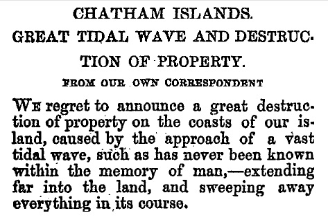
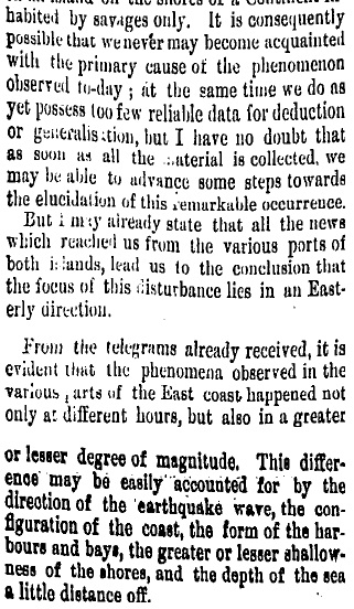
Hawkes Bay Herald, 12 September 1868
It’s just after midnight on 15 August 1868 in the village of Tupuangi on Chatham Island’s northwest coast and everyone is asleep in their whare after an ordinary winter's day, nothing's unusual. Then, what starts as a faint rumble turns into a roar, which turns into water rushing up the beach and through the village. Ten minutes later a larger surge arrives, and after five minutes another. Whare, made of ponga, kopi/karaka and wood from old shipwrecks, are smashed to pieces, and dragged out to sea. The land is stripped of trees and shrubs, and only sand, boulders and seaweed are left behind. Three families are washed away with their whare; those who survive scramble to higher ground and are left with nothing.
Nearby, at Waitangi West, a man named Makere is drowned by an incoming wave while trying to save a whaling boat that had been washed along the coast. There and elsewhere on the island, wooden houses, whare, sheds, stores, bridges and roads, some more than 10 metres above the high tide mark, are washed away or damaged. Dunes are scoured away and beaches are left strewn with seaweed and bits of buildings and what had been inside them.
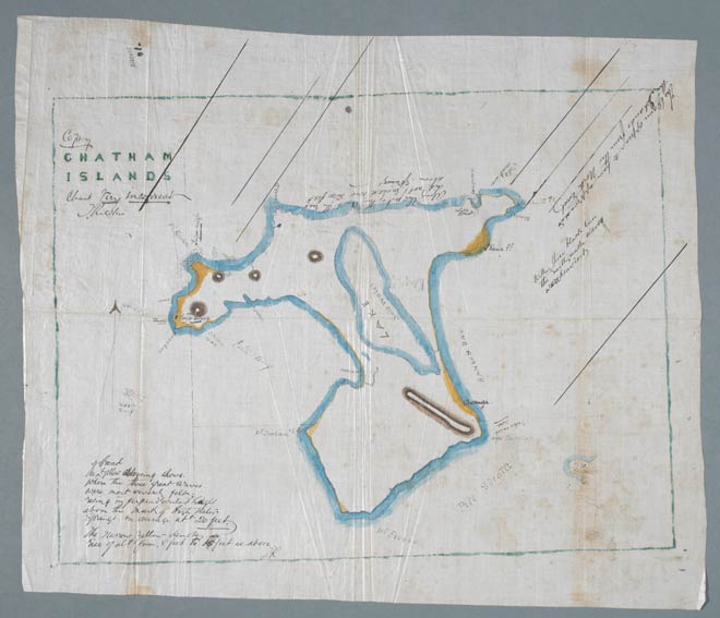
Runholder Thomas Ritchie's map of the 1868 tsunami inundation (marked in yellow) at the Chatham Islands. Source: Museum of New Zealand Te Papa Tongarewa
Two hours later, people in Okains, Le Bons and Little Akaloa Bays on Banks Peninsula are woken by the sea rushing into their homes. Three more waves arrive, 15 minutes apart, the third being the largest and most violent of all.
In Lyttelton Harbour it is mid-outgoing tide when the sea is suddenly sucked out of the port, leaving boats sitting on the mud. A few minutes later, the nightwatchman hears an 'immense' wave thundering up the harbour through the darkness. When it reaches the port the water surges in, rising 5 metres in 20 minutes, ripping boats from moorings and smashing them against wharves and each other.
Waves continue to arrive at Banks Peninsula during the day with another large surge at 2pm. Swirling muddy currents toss boats around in a sea of dead fish. By the end of the day several bridges (one 3km inland from the sea) and jetties are destroyed. Many homes are damaged and one has washed away. Roads are flooded and fences and piles of timber and firewood have all been washed away and are now scattered along the coast or floating in the bays.
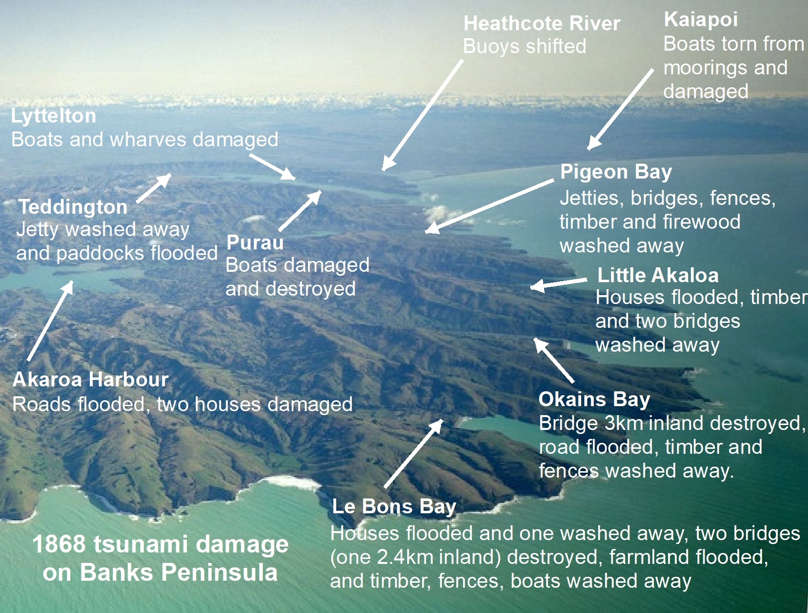
1868 tsunami damage on Banks Peninsula. Photo source: Lloyd Homer/GNS Science.
All along New Zealand’s East Coast from Mangonui in the north to Bluff in the south, and in a few places along the West Coast, people watch the sea rising and falling rapidly all day, especially in harbours and narrow bays, and notice sea water flowing up river mouths. Many boats are damaged and some people, drawn onto the beach by curiosity, are lucky to get out of the way of the sudden surges. People fishing on rocks in the Eastern Bay of Plenty find themselves suddenly up to their necks in water and having to swim ashore. Strange ‘tides’ and strong currents defy any normal pattern for the next 2-3 days, as people trade tales of narrow escapes and tidy up the mess left behind by one of New Zealand’s largest recorded tsunamis.
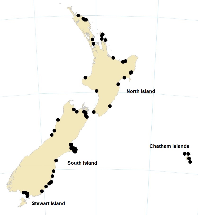
Locations around New Zealand where the 1868 tsunami was observed
Where did these waves come from?
With new-fangled international telegraph still years away, no one knew where the waves had come from or why. Geologists of the day, such as Haast and Hector, were quick to point out in local newspapers that the waves were probably the result of an earthquake or volcanic eruption, somewhere to the east.
Julius von Haast's letter to Lyttelton Times, 17 August 1868
It was two weeks before the schooner Rifleman arrived in Port Chalmers from the Chatham Islands to describe the disaster there to the rest of New Zealand. And it was six weeks before the source of the tsunami was known; the Panama mail steamer arrived in Wellington on 1 October 1868 with news of a huge earthquake and tsunami near Arica in northern Chile (now Peru) that had killed thousands of people. There was no magnitude scale in 1868 but scientists have since estimated, from the reported damage and modern-day analysis, that the earthquake was magnitude 8.5-9.0 and involved movement of a 600 km long piece of sea floor as the Nazca tectonic plate slipped down under the South American plate.
The tsunami had taken less than an hour to reach the Peru coast and geologists could now calculate that it had taken 15 hours to travel across the Pacific to the Chatham Islands, and 17 hours to reach New Zealand’s east coast. The animation below (courtesy of Jose Borrero at eCoast and Environment Canterbury) shows how most of the energy from this tsunami moved into the South Pacific, towards New Zealand and sloshed around us for hours - the hotter the colour the larger the wave. Because of the shape of the plate boundary off the South American coast, tsunamis created further to the south, in central Chile, tend to send more of their energy into the North Pacific.
The 1868 tsunami was one of the first tsunamis to be scientifically documented in detail. Austrian geologist, Ferdinand von Hochstetter, who had visited New Zealand in 1859/60 (leaving his name on a glacier, lake and a couple of mountains in the process), recorded the effects of the tsunami in South America and across the Pacific. Scientists even used the time it took for the tsunami to cross the Pacific Ocean to work out how deep the ocean was – before this, no one really knew.
Roll forward 150 years
One hundred and fifty years later we have an earthquake and sea level monitoring system that can tell us a big earthquake has happened in the Pacific Ocean, and that a tsunami may have been created, in minutes not weeks. This means we can be warned about most tsunamis before they arrive, unlike our rather surprised ancestors. But this anniversary is a reminder that we live on some small islands in the middle of a big ocean – occasionally tsunamis will come our way, possibly within minutes from very close to our shores with no official warning.
The animations below show what would happen if the 1868 tsunami turned up again in Lyttelton and Christchurch today. Notice that even where there is not much flooding of land, the currents in the water are strong and dangerous.
What you can do now
Preparing for tsunamis isn’t at the top of most people’s favourite-things-to-do list. So, here’s a bite-sized thing you can do in 5 minutes now: dust off your tsunami evacuation zones.
If you live or work in an evacuation zone, you need to go inland or to higher ground out of the evacuation zones straight away (that’s right – without waiting for someone else to tell you) if you feel an earthquake that is so strong it is hard to stand up, or a mild/moderate earthquake that goes for more than a minute. Have a quick run through in your head of who and what you would grab and where you would go.
Also, if you live or work in an evacuation zone, have a think about where you would go if you were told to leave because a tsunami is arriving in, say, 6 hours and you have a bit more time (your local Council will set up civil defence centres if you don’t have friends and family to go to).
If you don’t live or work in a tsunami evacuation zone, do you have enough tea bags and biscuits to look after your friends or family who may turn up from closer to the coast?
If you want to find out how to make life a bit easier for yourself and your friends and family if a tsunami is coming check out the tips on the Ministry of Civil Defence & Emergency Management website. You can read more accounts of the 1868 tsunami, and other historic tsunamis in GNS Science’s New Zealand Tsunami Database.