What is happening at Whakaari/White Island.
Today we raised the Volcanic Alert Level at Whakaari/White Island to Level 2 due to increased uncertainty caused by loss of real-time monitoring capability. We take a deeper look into what this means.
GeoNet’s Whakaari/White Island volcano monitoring network operates in a harsh environment that needs regular servicing and maintenance to function well. As we haven’t returned to Whakaari since before the 2019 eruption, we haven’t been able to service this equipment for over 2 years.
Although the on-island equipment has performed well in these extreme conditions, without maintenance or repair, for far longer than we were expecting, it has slowly failed. Our sole remaining seismo-acoustic station (that detects earthquakes and explosive airwaves) stopped working on 5 August. This has affected our ability to assess near real-time volcanic activity at Whakaari.

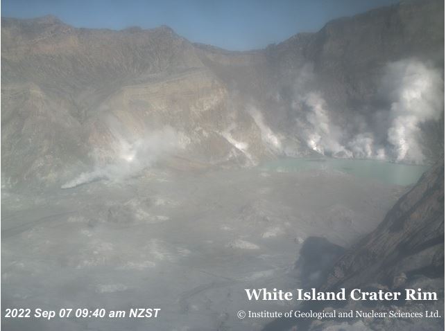
View of Whakaari/White Island during monitoring flight on 31 August
Why change the Volcanic Alert Level?
Although our recent observations (31 Aug) are consistent with generally low levels of volcanic unrest, due to the uncertainty about the level of activity on island, because of the lack of real time data, and the fact that activity can change rapidly, we have raised the Volcanic Alert Level (VAL) to Level 2 and the Aviation Colour code to Yellow.
Acknowledging the recently lost access to real-time data from Whakaari/White Island, Nico Fournier, GNS Science Volcano Science Advisor, comments: “The loss of this real-time data means we are effectively unable to distinguish in near real-time between Volcanic Alert Level 1 (minor volcanic unrest) and Volcanic Alert Level 2 (moderate to heightened unrest). We are not increasing the VAL due to a noticed increase in activity but, instead, due to the uncertainty and decreased timeliness of our interpretation caused by the loss of real-time data. We feel this prudent approach more accurately reflects the level of uncertainty about what might be happening at Whakaari in near real-time, in between our gas/observation flights".
How will you monitor the volcano?
We will continue to conduct regular observation flights and increase their frequency when weather allows. We use these to identify changes in the crater and take the temperature of the vent area with a Thermal IR camera. We also conduct regular gas measurement flights to study the emission of volcanic gases.
Our volcano webcam on the north rim continues to occasionally provide us with valuable images of the volcano, and we can detect changes in activity from those too. As always, we will keep you posted in Volcanic Activity Bulletins on our website.
View from the North Crater Rim Camera
Why have you not gone back to the island yet?
It is taking some time for us to work through the many different aspects of a mission to the island, but we are working hard on a plan to safely return to the island to begin critical maintenance.
Although we can’t prevent natural hazards, we can prepare for them – and we should.
The Volcanic Alert Level reflects the current level of volcanic unrest or activity and is not a forecast of future activity. Eruptions can still occur with little or no warning.
The National Emergency Management Agency's (NEMA) Get Ready website has information on what to do before, during and after volcanic activity.
Toka Tū Ake EQC have information for preparing your home for natural hazards.
Find out more about Whakaari volcano
How do we monitor our volcanoes?
Media Contact: 021 574 541 or media@gns.cri.nz