
Landslides, dams, and a reminder to take care in the outdoors over the holidays
While uplifting land along the Kaikoura and Marlborough coasts, the magnitude 7.8 Kaikoura earthquake was also busy shaking a fair bit of land down.
The earthquake triggered thousands of landslides throughout North Canterbury, Kaikoura and Marlborough, and some of these dammed rivers and streams behind them. Our landslide team have spent many hours mapping and monitoring these landslide dams along with staff from Environment Canterbury and Marlborough District Council, and colleagues from the US Geological Survey.
Going into the Christmas break there are still many potentially active landslide and rock fall areas, and landslide dams with water ponded behind them, from North Canterbury into Marlborough. You'll need to be particularly careful if you are doing anything near a river, or heading into the back country in this area over the coming months.
What are the landslides and landslide dams up to?
Over 80,000 landslides and rockfalls have occurred throughout North Canterbury, Kaikoura and Marlborough, particularly in the Seaward Kaikoura Range, the Amuri Range, the hills between the Inland Road and State Highway 1, and the lower country of the Conway, Leader and Stanton rivers. Using helicopters, GPS, aerial photos and satellite imagery we’ve now mapped 196 places where landslides have dammed rivers, blocking or restricting the flow. Many rivers have multiple dams – up to four or five in some cases. Some of these dams are soft rock dams formed by large chunky slumps of soft mudstone, and some are hard rock dams formed by rock falls or avalanches (really large tumbly rock falls) of hard rock. Most dams will break (fail) within a year by either overtopping and erosion during or immediately after heavy rainfall, or by internal erosion and collapse. Others may stay put and become permanent features with water running over or percolating through the dam (see our previous story to find out more about what landslide dams are and how they behave). As there is yet to be any heavy rainfall since the earthquake the newly disturbed river catchments are yet to be put to the test. Most of the 196 mapped landslide dams are small and pose little risk, but we’ve been actively monitoring eleven landslide dams in the Conway, Gelt, Hapuku, Leader, Linton, Medway, Ote Makura, Stanton, Towy, and Waima catchments that could cause a flood wave and damage in downstream areas should they break. Large lakes have formed behind the dams in the Conway, Linton and Hapuku catchments.
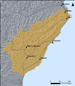
Area where landslides have occurred from the Kaikoura Earthquake.
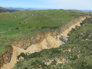
Mt Cookson Landslide. Photo by S Cox.
One of the monitored dams on the Towy River, a tributary of the Conway River in the Amuri Range, has failed already. One of the least stable dams, the water ponded behind it overtopped and cut a channel through the dam between 2 and 5 December, releasing a series of gravel-laden flood waves that reached about 1km down the river.
As well as monitoring the landslide dams, our scientists have been modelling how much downstream land could be flooded if the dams break in a worst case scenario (i.e. if the dam fails all in one go and all the water behind it is released). We’ve now handed over monitoring of the dams to Environment Canterbury and Marlborough District Council. You can keep up to date with the latest on the Canterbury dams on Environment Canterbury’s webmap.
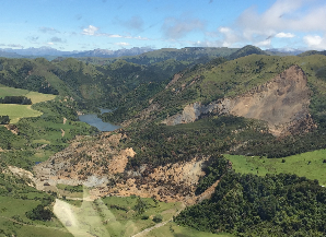
Landslide on the Leader River. Photo by S Dellow.
What you need to be aware of – in rivers, the back country and the coast
People should stay out of stream channels and river beds wherever possible from the Waiau River north to the Awatere River.Landslide dams could fail at any time, but particularly during or immediately after heavy rainfall or an aftershock, creating a sudden flood downstream. A lot of sediment is now flowing into river and streams, causing rivers to behave less predictably. If you see one of your mates in their digger in the riverbed, you may like to politely point this out (once they are out of the river – don’t put yourself in danger). Also, pitching your tent right beside a river is also probably not the wisest move – camping on an open elevated area is better. It may be difficult to tell if a landslide dam suddenly fails upstream. Tell-tale signs include changes to the water colour (usually to a dirty brown colour) and strange or loud noises from the river valley. These are cues to get out of the way. Landslide dams might not fail all in one go, so don’t assume that the danger has passed if there is a flood wave.
Backcountry users should expect walking tracks and routes, and 4WD tracks to have changed significantly.There are treefalls, landslides and rockfalls, loose rocks and cracks in the ground right through North Canterbury, Kaikoura and Marlborough and further landslides and rockfalls are likely during heavy rainfall or in an aftershock. Some tracks are now covered with rock or sections have collapsed, requiring major work before they can be used again, and Barratts Bivvy in the Hapuku catchment was destroyed by a rock avalanche. What may have been a relatively easy walk or drive may now be much harder and longer. Streams and rivers may have new pools and rapids and vehicle river crossings, including entry and exit points, may have changed.
The Department of Conservation has closed all huts from the Seaward Kaikoura Range north to the Chalk Range, including the Clarence Reserve and the Isolated Hill Reserve (Sawcut Gorge). These huts all need further earthquake damage assessments in the New Year, and access to them is also dangerous in places.
We recommend you check out the Department of Conservation website and have a yarn with local farmers about your planned route before heading into the hills.
People visiting the coast should also be aware of the potential for further land movement. There were many landslides off the coastal hills and cliffs from the Waipara River to Cape Campbell during the earthquakes and rocks will continue to fall off these for some time. Uplift of the seabed along this area may also have changed the depth of reefs or the pattern of rips and currents.
People-made dams
We’ve had few questions about farm dams. The safety of farm dams is the responsibility of the dam owner. If you have a farm dam you should check it for any damage and if you have concerns you should engage an engineer to investigate. For more information you can contact Environment Canterbury or Marlborough District Council.
Updates
Staff at Environment Canterbury and Marlborough District Council are now monitoring the landslide dams and assessing how the increase in gravel in the rivers will affect future flooding. You can keep up to date with the latest developments on their websites.
We plan to continue mapping and studying the landslides triggered by the earthquake throughout North Canterbury, Kaikoura and Marlborough over the coming months and will keep you updated on what we find.