
East Coast slow-slip event update
This is an update on the east coast slow-slip event that our scientists have been monitoring since late March 2019.
Our GPS sites on the east coast near Gisborne and Mahia first started registering the slow-slip event in late March 2019. In our first news story, we explained that we would keep you updated on how this event unfolds.
This event has been happening for around a month now and our scientists measured the largest amount of eastward movement during the first week of the event. The slow-slip has continued at a slower, but steady rate since then.
This slow-slip event is now as large as the biggest previous slow-slip event we recorded off Gisborne in March 2010. So far, the plate movement that has occurred in this event is equivalent to a magnitude 7.0 earthquake.
To measure a slow-slip event, we look for an increased rate of eastward movement of GeoNet GPS sites on the east coast. This eastward displacement reflects slow-slip movement on the Hikurangi subduction plate boundary, which lies around 12 km beneath the North Island’s east coast.
The below graphs show the east component of the GPS site positions over the last several years - with previous slow-slip events visible. You can see that the GPS site MAKO (located just north of Gisborne) has undergone the largest displacement in this event, with over 4 cm of movement. A GPS site close to Gisborne (GISB) has moved to the east by approximately 3 cm.
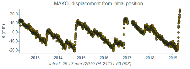
MAKO GPS site showing eastward displacement 26/4/19
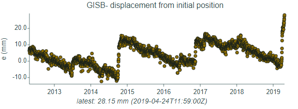
GISB GPS site showing eastward displacement 26/4/19
We’ve also noticed in the last week that some of our southern Hawke’s Bay GPS sites, such as at Cape Kidnappers and Pawanui, have been picking up movement and are joining in on this slow-slip event. This suggests that the rupture of this slow-slip event is propagating south now too. Propagation of slow slip events from offshore Gisborne into the Hawkes Bay region was also observed in 2016.
Scientists can use displacement data from GeoNet GPS sites on the earth’s surface to figure out how much movement has occurred on the Hikurangi Subduction Zone below the eastern North Island. This reveals that this slow-slip event has involved up to 20 cm of movement on the Hikurangi plate boundary offshore of Gisborne, and possibly even more offshore Hawke’s Bay, as you can see from the below slip model.
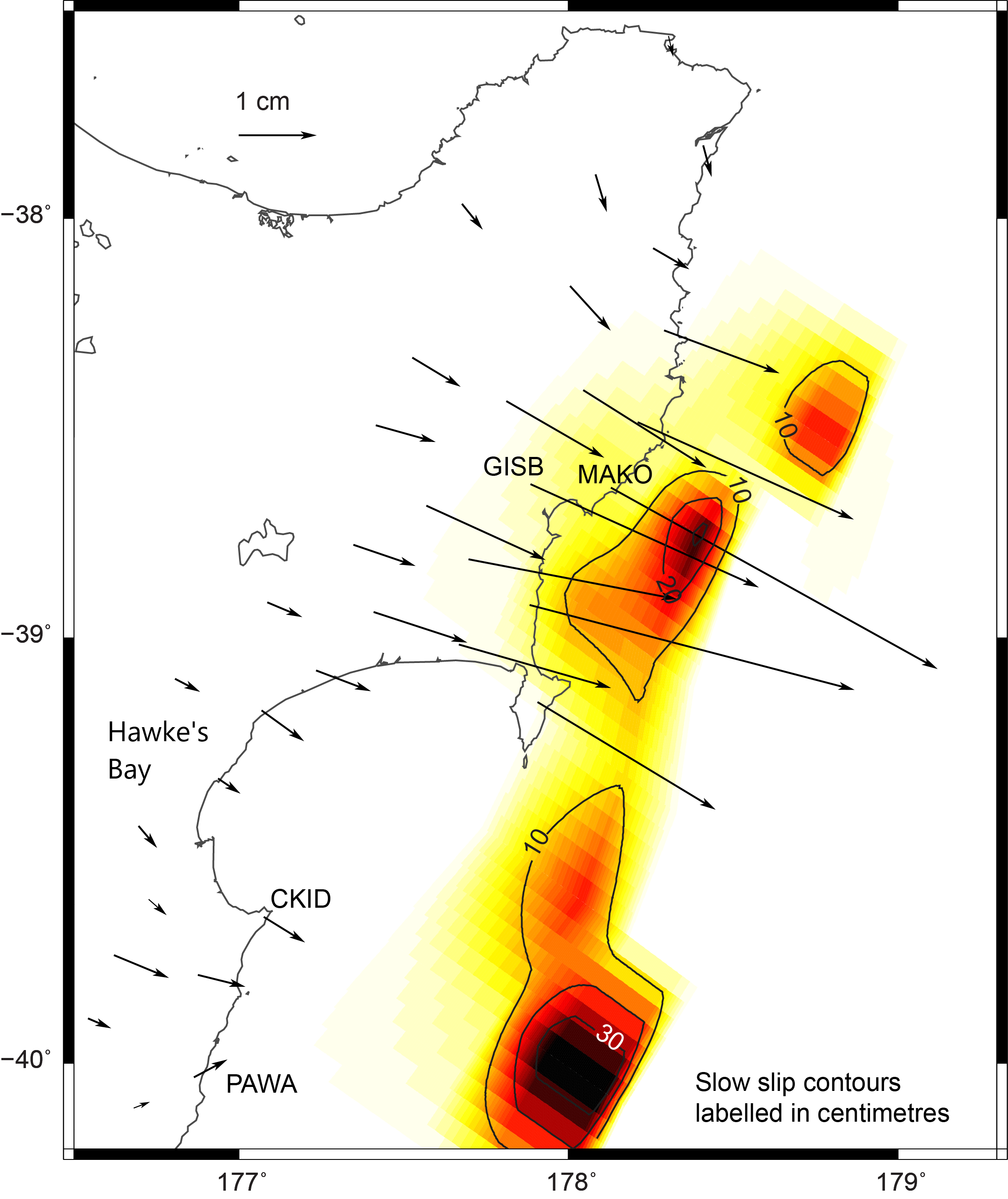
Slow-slip model - black arrows show horizontal displacement of GPS sites over the last month, and the colours represent estimated slow slip movement along the Hikurangi subduction plate boundary
The estimated amount of movement on the Hikurangi Subduction Zone offshore Gisborne in this event represents up to 4 years’ worth of tectonic motion between the Pacific Plate and the eastern North Island, which move together at approximately 5 cm per year beneath the Gisborne area. You can see that these slow-slip events play a very big role in accommodating tectonic plate motion in New Zealand!
Our scientists have been anticipating this slow-slip event, as our slow-slip record has shown regular events every 1-2 years, and much larger events every 4-6 years. Fortunately, our scientists currently have seafloor instruments deployed in this area that will give better insights into what has happened offshore. They are planning to retrieve those instruments in November, using NIWA’s research vessel Tangaroa.
Our earlier story explained that there was an associated patch of increased seismic activity at Mahia Peninsula. That seems to have died down considerably, although there are still small earthquakes happening in that region. We think there may be the possibility of a link between this slow-slip event and some of the lower Hawke’s Bay/Tararua District quakes happening this week, namely at Dannevirke and Porangahau. Most of these earthquakes have been too small for you to feel, with the exception of the Dannevirke quake which had over 2,700 felt reports.
Slow-slip events are a great reminder that we live on a very active tectonic plate boundary here in New Zealand. Like always, we would like to remind you to help keep you and your family safe by having an earthquake plan. Know what you should do in the event of a large earthquake, be sure to Drop, Cover and Hold. If you are near the coast and you feel a Long OR Strong earthquake, get to higher ground once the shaking has stopped in case a tsunami was generated.
To read some of our previous news items on slow-slip quakes, read here:
Slow slip event occurring along the East Coast of the North Island
What do these slow-slip events mean for future large earthquakes?
For more information on how to get prepared for an earthquake, visit Civil Defence's website happens.nz and for information on how to secure your house and belongings, visit eqc.govt.nz/be-prepared
Attributable to - Laura Wallace – GNS Science Geophysicist
Media enquiries - media@gns.cri.nz or 021 574 541