
The latest information on the Horowhenua earthquakes
On Monday 25 May a strong M5.8 earthquake occurred 30km north-west of Levin. This was followed by hundreds of aftershocks, including a M5.2 on Tuesday 26 May 2020.
The M5.8 earthquake was felt around New Zealand, with nearly 37,000 felt reports coming into our website. This tops our previous felt report record from January this year, a M5.4 earthquake in a similar location, that received over 26,500 reports.
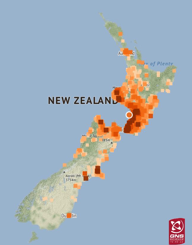
Felt reports for the 25 May 2020 earthquake
Monday’s earthquake has been followed by over 250 aftershocks (that we have been able to locate) ranging in size from M1.7 to the biggest, a M5.2 earthquake that occurred at 12:34PM on Tuesday 26 May 2020. This aftershock was reported felt by 20,000 people throughout central New Zealand.
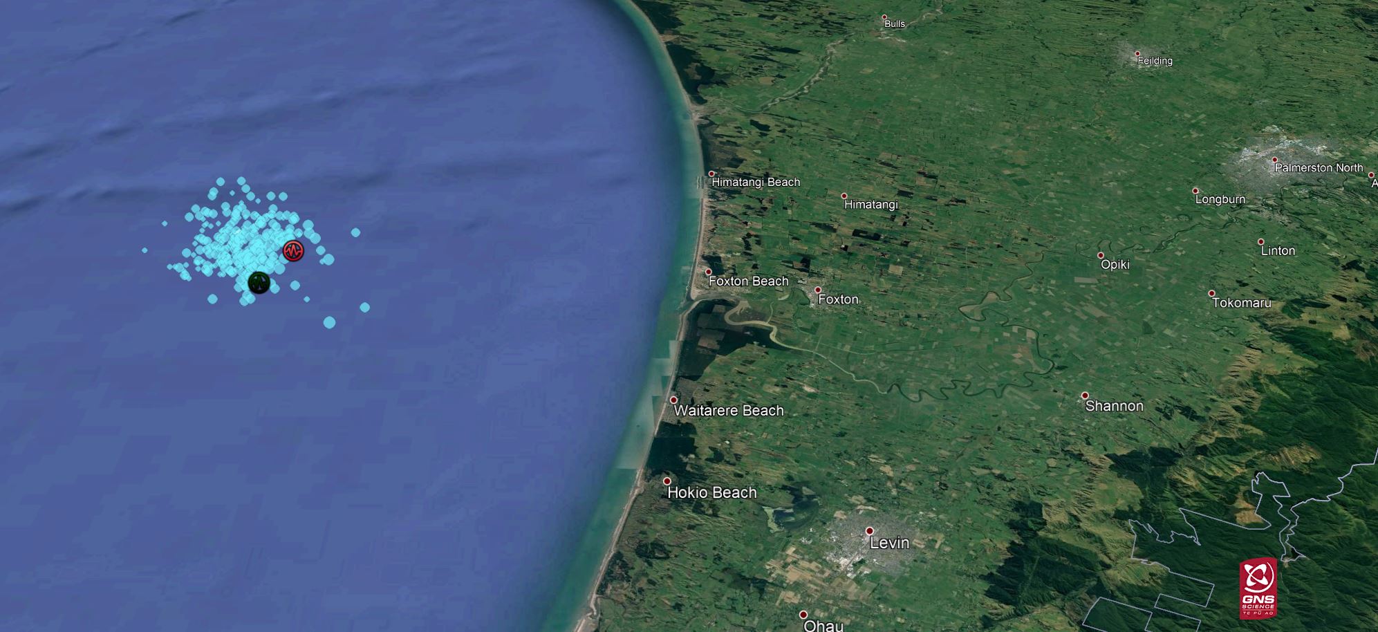
M5.8 earthquake (red circle) and aftershocks (M5.2 aftershock - green circle) as at 12:30pm May 29 2020
Our modelling of this earthquake sequence shows that there is an increased probability of a larger earthquake in the vicinity of the original rupture zone, however, seismologists at GNS Science say that the overall probability of a M6.0 or greater earthquake remains low (2% within the next month, see below for more details). The most likely outcome is that the aftershock sequence will continue to decay, with earthquakes smaller than the main shock and becoming increasingly less frequent.
The faults off the Kapiti Coast are known to be reasonably active and commonly produce a number of earthquakes each year. Mostly these are less than magnitude 5. This week’s quakes were slightly larger than normal, but still within the known range of the offshore Kapiti fault system.
Tsunami are very unlikely to be generated by earthquakes with magnitudes below M6.5. However, both the offshore Kapiti faults and the Hikurangi subduction zone are capable of larger earthquakes which have the potential to cause a tsunami, so it is important for coastal residents to remember the “Long or Strong, Get Gone” message and to be familiar with their local evacuation zones.
The below diagrams show a cross section of the North Island with ten years of M3+ earthquakes in orange, with this week’s earthquakes nearby Levin in blue. These earthquakes also show where the Pacific Plate starts to dip more sharply under the Australian Plate.
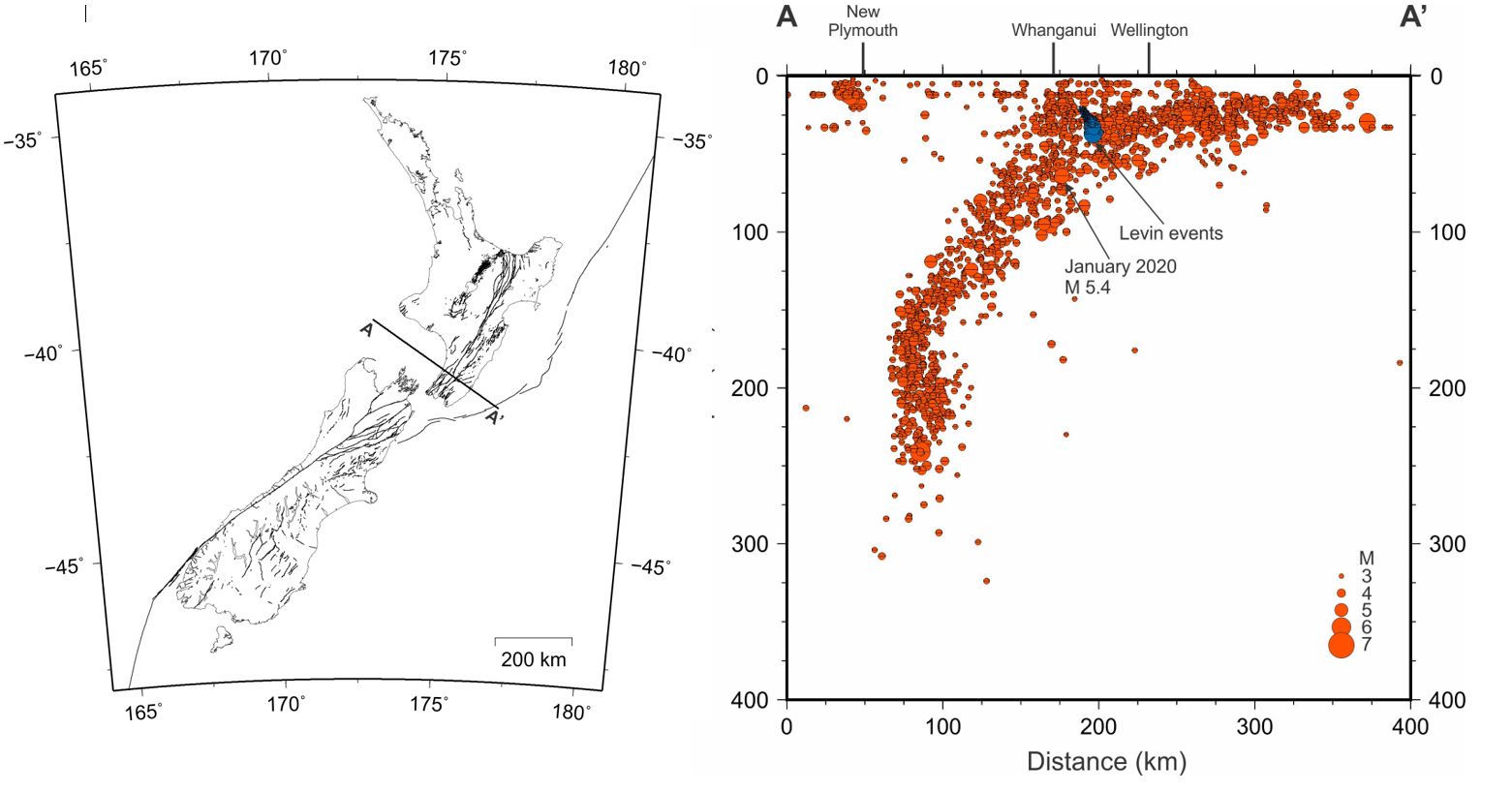
Cross section of the North Island showing 10 years of M3+ earthquakes
These recent quakes have occurred 20 – 40 kms below the surface, near the interface of the Australian Plate and subducting Pacific Plate – at the point where the Pacific Plate starts to dip more sharply. The flexed Pacific Plate builds up stress, which is largely released as ‘normal faulting’ earthquakes, like those over the last few days. Further interpretation and modelling of the earthquake sequence shows that the quakes are likely occurring at depth in the overlying Australian Plate, rather than the subducting Pacific Plate.
Seismic energy generated at the interface between the two tectonic plates travels very effectively along the plate boundary, which helps explain why these earthquakes have been so widely felt.
The earthquakes have also occurred in the Horowhenua-Manawatu region where the Hikurangi subduction zone slips approximately every five years in slow-motion earthquakes, or "slow-slip events". Manawatu slow-slip events typically last about a year, and the last one occurred in 2014-2015. Although there are no signs on our GNSS network of a Manawatu slow-slip event starting up yet, our scientists are anticipating one to begin sometime in the next year, based on the timing of past events. It is possible that Monday's earthquake might trigger a Manawatu slow-slip event to start a little earlier than expected, as we observed following some past earthquakes, like Kaikōura. Our scientists will continue to monitor the GNSS timeseries to look for any signs of a Manawatu slow-slip event starting up, and we will provide an update if this happens.
More detail on Aftershock forecasts
An earthquake of the size of Monday’s event would on average be expected to have about 10 aftershocks of magnitude 4.0 and above in the first year, including one of magnitude 5 or larger. On average, seven would occur within the first four days. This agrees well with what we have seen so far, with the occurrence of five aftershocks of magnitude 4 and above, including one of magnitude 5.2 on Tuesday. The rate of expected aftershocks is highest right after the mainshock and initially decays quickly. A large aftershock would have its own aftershocks increasing the initial expected rates. From Friday 29 May 2020 at lunch time, the expected number of magnitude 4s for the coming week is 1, with a possible range of 0 to 5 (see table below). The probability of a further earthquake in the magnitude range 5 – 5.9 within the next month is 17% (unlikely) and for a M6.0 or higher earthquake the probability is 2% (very unlikely).
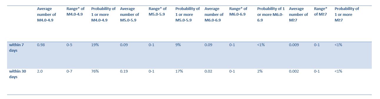
Forecast for 0.1x0.1* degree box covering the aftershock area at 12 noon, Friday 29 May 2020. * 95% confidence bounds.
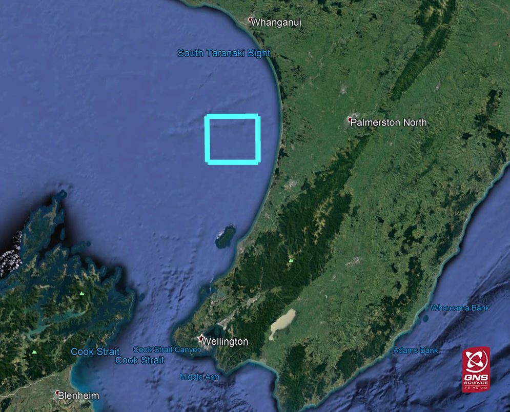
Aftershock forecast area shown by the blue square.
While a 2% probability might seem low to some people, the expected earthquake rate is several thousand times higher than the long-term rate from the National Seismic Hazard model. This is because the area usually has a very low probability of earthquakes. The rate will remain elevated for decades before decaying to the long-term background, which is normal for earthquakes of this magnitude.
For more reading you can check out how we make earthquake forecasts, why we make earthquake forecasts, and what is the difference between a forecast and a prediction?
Remember in an earthquake to Drop, Cover and Hold
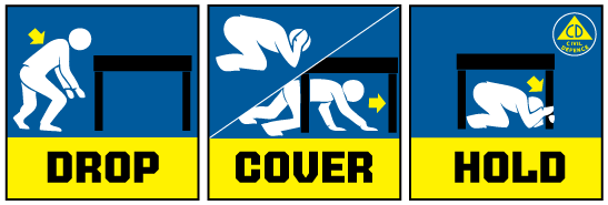
Drop, Cover and Hold
If you feel a long or strong earthquake, or receive a tsunami alert, get to higher ground, or as far inland as possible immediately.
The National Emergency Management Agency (NEMA) have a great website with information on what to do before, during and after an earthquake. And the Earthquake Commission (EQC) have a helpful website with information on how to get your home, apartment, or rental prepared for a natural disaster.
Need to Talk? If you would like support or advice, have feelings of anxiety, stress, prolonged fear, hopelessness or anger, or if you just need to talk with someone. Please text or phone 1737 to speak to a trained councillor in the National Telehealth Service. Its free to call or text.
Media Contact: 021 574 541 or media@gns.cri.nz