Taupō Earthquake Update
Our experts have been busy collecting and analysing data to help us understand exactly what happened during and following the M5.7 earthquake at Lake Taupō on 30 November, including ground shaking, landslides, volcanic activity and tsunami. Here is an update on what we know so far.
Aftershocks
Following the M5.7 Taupō earthquake we have located over 680 aftershocks (as of this story being published), with the most recent felt aftershock being a M3.4 on 12 December. The aftershock sequence (size of events and numbers) is as we would have expected for a mainshock of M5.7.
You’ll likely notice the reported magnitude has increased since our initial reporting by 0.1 units to 5.7. This reflects the greater accuracy we have been able to bring to the earthquake analysis since the earthquake happened.
Watch an animation of the earthquake and aftershocks:
The magnitude and rate of aftershocks has started to decline but is expected to continue for several weeks. This can be seen in the timeseries below:
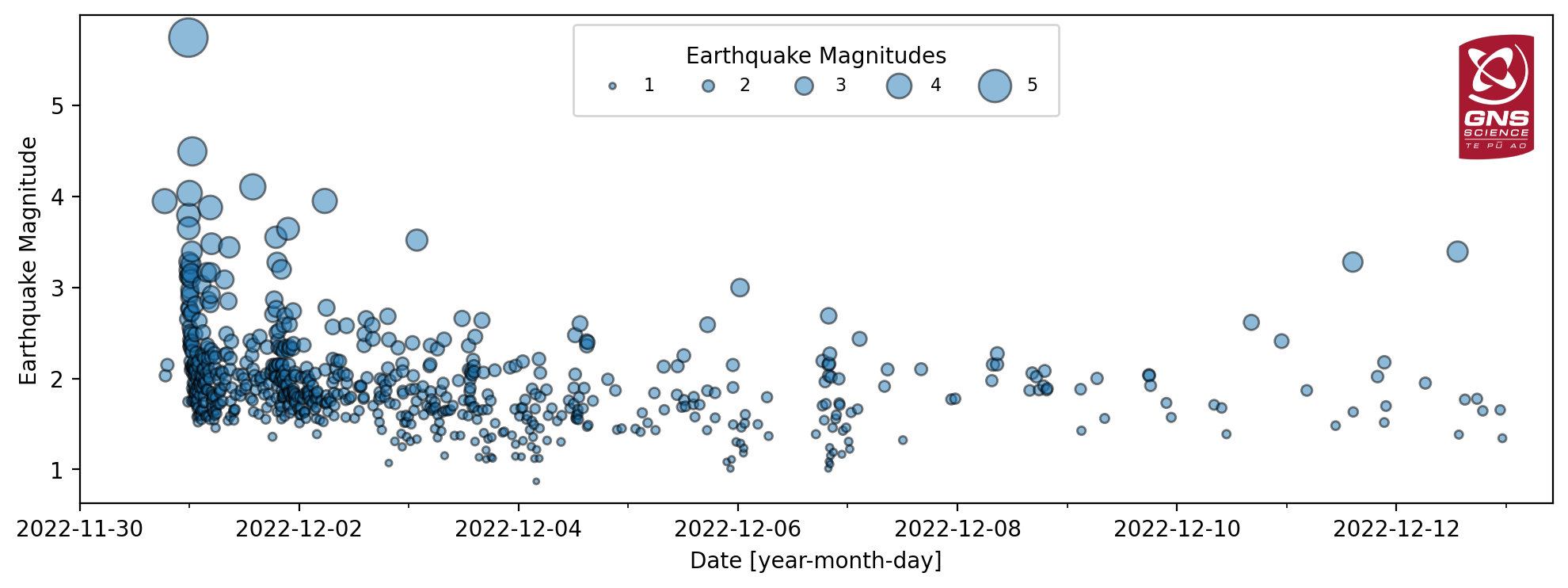
Earthquake timeseries showing gradual decline in aftershock magnitude and number.
Within the next 30 days, there is an estimated 11% chance (very unlikely) that there will be an earthquake of magnitude 5 or above in the Taupō area (as shown in the animation above). This will be our last forecast for this event. Read more about the forecast and other facts on the earthquake here.
Ground Deformation (Movement)
In addition to the shaking of the ground during the earthquake, our sensitive GNSS (Global Navigation Satellite System – commonly referred to as GPS) instruments in and around Lake Taupō measured ground movement. Our instrument at Horomatangi reef (TGHO) moved 18 cm upwards during the earthquake and 25 cm to the southeast, which is the largest ever recorded ground movement at this location. The station has also shown what is called ‘post seismic deformation’; it moved a further 4 cm to the southeast in the week following the earthquake. GNSS stations onshore are recording a much smaller movement (~10 to 20 mm) associated with the earthquake.
Tsunami
A small tsunami was generated in Lake Taupō on the night of the M5.7 earthquake. The waves travelled across the lake and surged a few metres across many beaches, leaving behind some strands of pumice, sticks and sand. The larger surge at Wharewaka Point, where the beach is known to have retreated by some 20 m, may be associated with a possible underwater landslide. It is expected that models generated by our experts in the coming weeks will allow us to understand these details further.
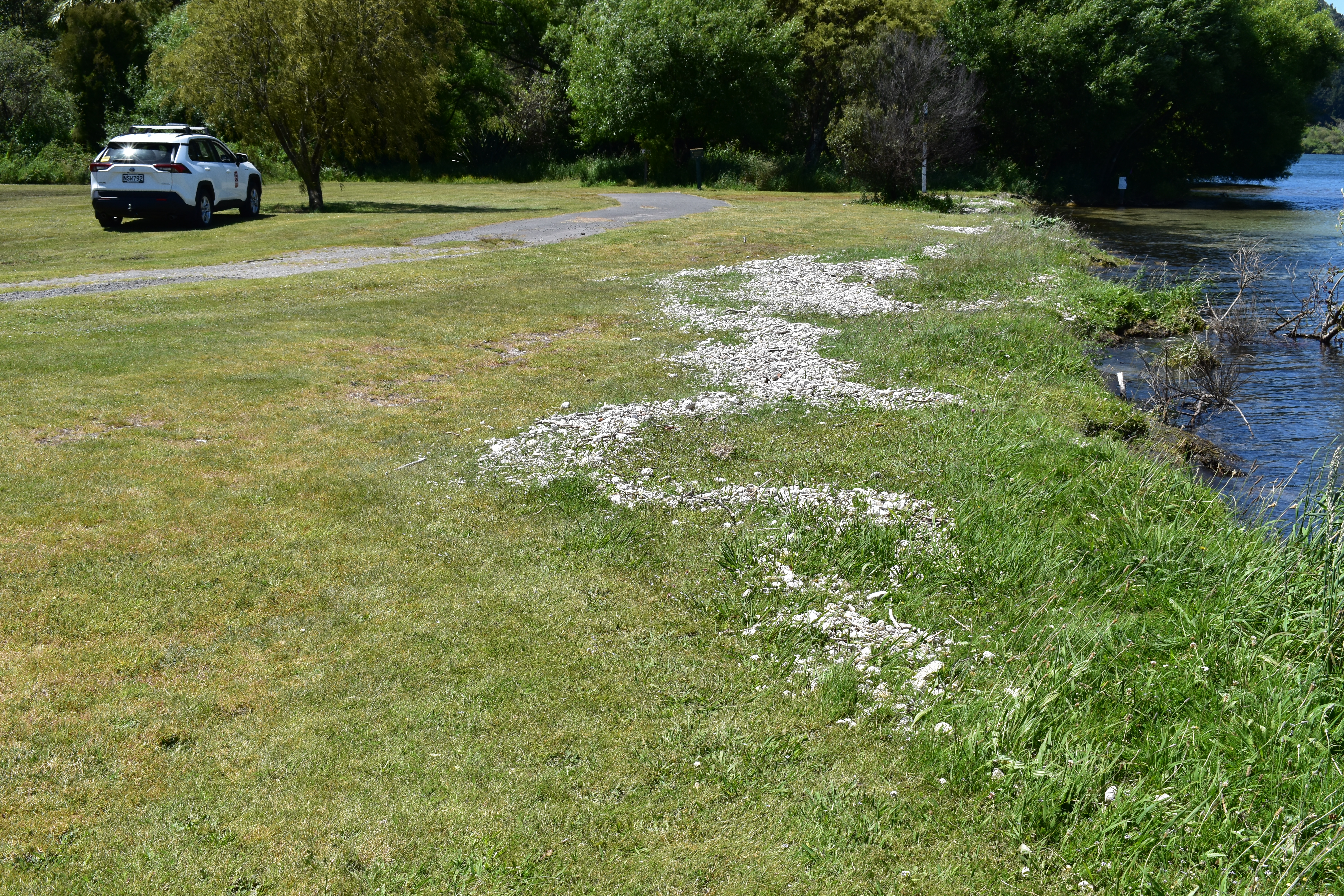
Band of pumice debris stranded nearly half a metre above lake level at Whareroa Bay (10 km North of Turangi) by the 30 November Lake Taupō tsunami.
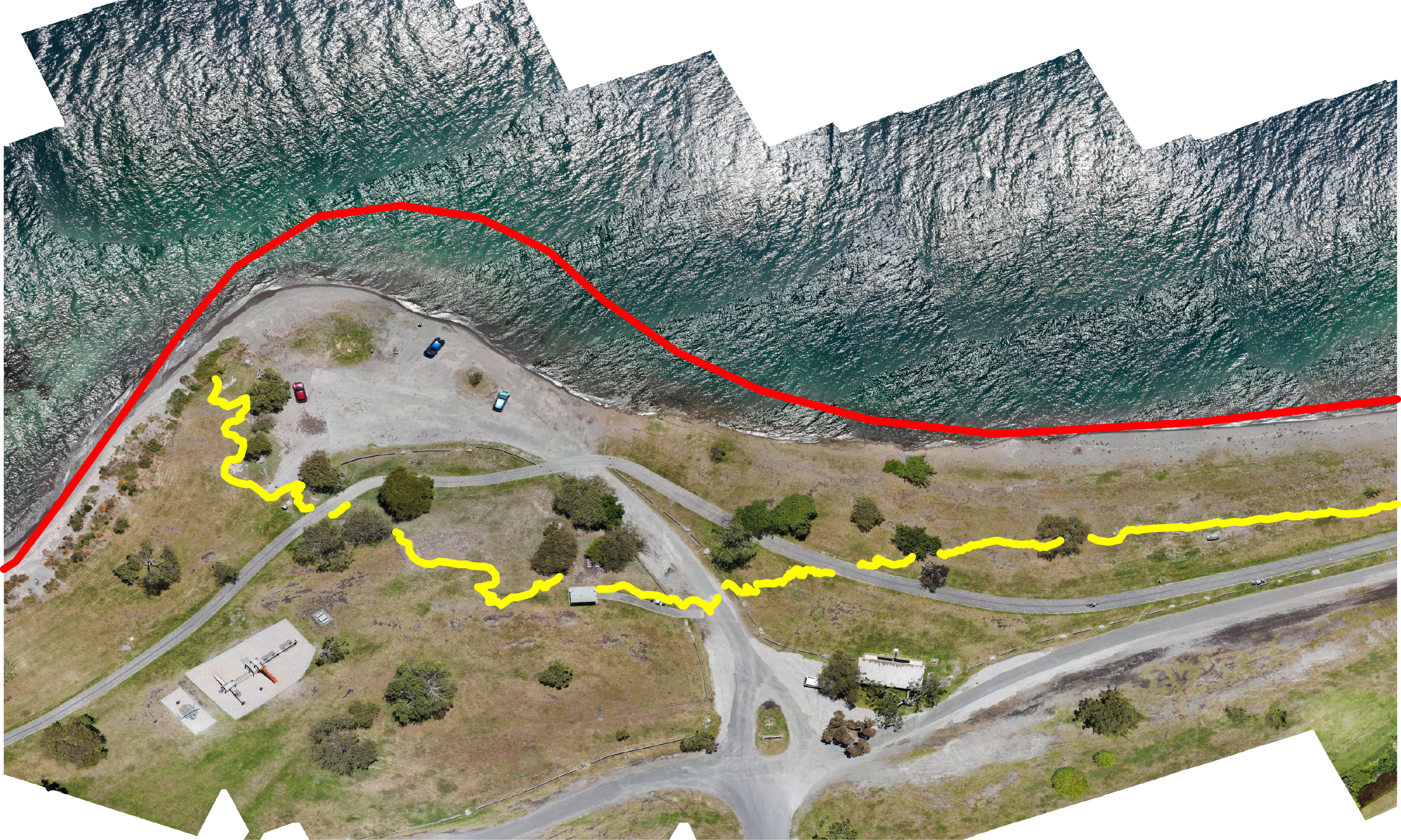
Band of pumice debris (yellow line) stranded at Wharewaka Point, close to Taupō Airport, by the 30 November Lake Taupō tsunami. The red line symbolizes the shoreline before 30 November 2022. Drone imagery from GNS Science.
We have surveyed the deposits and found that the tsunami wave pushed debris almost 1 metre above the lake level, when it reached the western shores at Kuratau and on the east side of the lake at Motutere. In some places, the lakeshore had been undercut by waves and small areas had collapsed a metre or so back. The tsunami had less impact on the northern shores, for example at Whakaipo Bay where the wave left pumice debris less than 30 cm higher and less than a metre inland from the high-water mark. Little or no change was seen at Kinloch, Acacia Bay, or in the western bays. However, major changes happened at Wharewaka point near Taupō, with substantial washout of the foreshore and beach, and pumice debris stranded to a maximum of about 40 m inland from the lake. We are running computer models of the tsunami to understand how it might have been generated and spread across the lake. We are also investigating the specific cause of the effects at Wharewaka Point.
Landslides
More than 30 landslide events have been triggered by the M5.7 earthquake. This is not unexpected, given the severity of the shaking, and the timing of the earthquake, which followed several weeks of particularly wet weather. Landslides were identified through a combination of liaison with Taupō District Council, public reports submitted to GeoNet via our online survey (did you see something?), field mapping by GNS staff, and an analysis of satellite images acquired in the days following the earthquake.
Most landslides were small slips on steep cut slopes close to roads (particularly in northern regions, close to Acacia Bay), while larger rockfalls (perhaps up to the size of a bus) were identified closer to the epicentre in the vicinity of Hatepe. Most were generated on the White Cliffs along the eastern lake shore north of Hatepe, just 7 km from the earthquake epicentre. Here, a several-hundred-meter-long (though relatively shallow) section of the cliffs collapsed into the lake, generating a large white plume of sediment that could still be seen stretching north along the coastline several days after the earthquake. Further onshore, a number of larger rockfalls in the vicinity of Hatepe appear to have occurred from cliffs within river valleys close to the lake. These are areas that we know are prone to long-term erosion, and earthquake-induced rockfalls, though not incredibly common, can be considered a normal landscape process.
Aside from the rockfalls on the White Cliffs, the most notable single earthquake-triggered land movement, was located over 15 km north of the epicentre, at Wharewaka Point (see the image above). It is possible an underwater landslide occurred at the location of the popular swimming beach, causing 170 m of the shoreline to subside into the lake, with a maximum retreat of up to 20 m. Whilst still under investigation it is possible that the collapse of the beach into the lake drew water in behind it, generating the local tsunami that washed up onto the picnic area behind it.
Underwater landslides are known to be some of the largest landslides on earth and can trigger tsunamis, however, there is currently no evidence to suggest the Wharewaka Point landslide generated the larger lake-wide tsunami observed following this earthquake. We hope to learn more about the much-loved beach’s "journey” beneath the surface of Taupō Moana as we continue to study the event over the coming weeks.
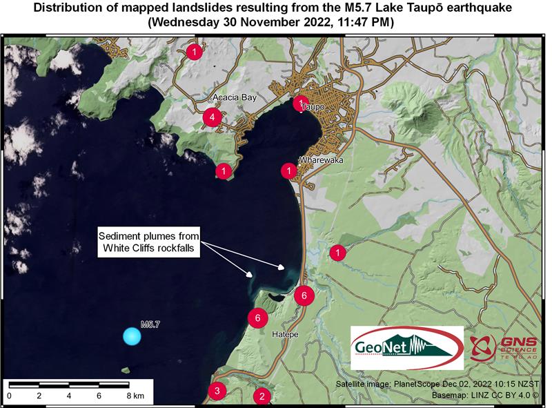
Clusters of mapped landslides following the M5.7 earthquake. The earthquake epicentre is marked in blue, red circles indicate the centre of landslide clusters and number of events near each locality. The satellite image of Lake Taupō was acquired by PlanetScope approximately one and a half days after the earthquake and includes two large sediment plumes flowing north from the rockfalls at the White Cliffs.
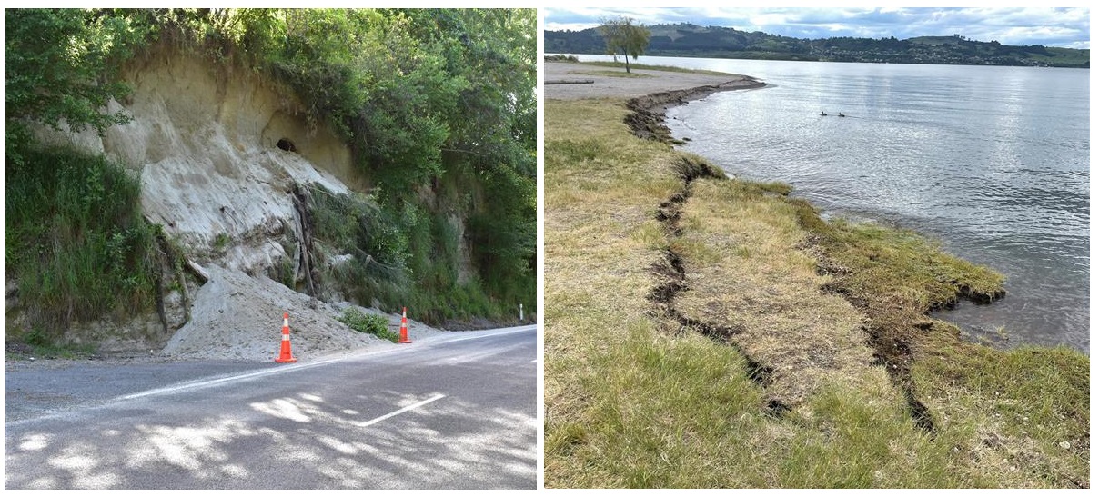
Left: Following several days of moderate rainfall, many small slips such as these ones on Mapara Road near Acacia Bay, were triggered by the M5.7 earthquake. Right: A possible underwater landslide at Wharewaka Point caused the shoreline to retreat by up to 20 m and may have generated a local tsunami that washed 40 m inland.
Instruments
Our technicians have upgraded a semi-continuous GNSS station at the NW shore of Lake Taupō to allow for real-time analysis of the deformation data. We are also preparing to install a new GNSS station near Karangahape at the SW shore. These two sites will significantly improve the spatial coverage of our GNSS network to monitor ground deformation around Taupō Volcano.
We have also added seismic sensors at our existing GNSS site at Ouaha hills and another one at Karangahape, at our future GNSS site. This will help our scientists better locate the earthquakes under the lake.
Public Survey
Following the earthquake, researchers asked the public for more observations via an online survey, and we have had 41 public reports submitted. These ranged from noticing the ground shaking and unusual sounds during the earthquake to seeing landslides and debris washed up on the lake shore. Many of those reports included photos taken by the public. These photos and descriptions helped the field and science teams prioritise field work and understand more about the relationships between earthquake, landslides and tsunami.
Did you notice something unusual? Follow this link to let the experts know.
So, what next?
Minor volcanic unrest has been ongoing at Taupō Volcano since May 2022, and the Volcanic Activity Level (VAL) was raised to VAL1 in September 2022. This recent earthquake activity is within the range that had previously been anticipated and is consistent with minor volcanic unrest, and this activity does not warrant a move to a higher volcanic alert level. Prior to 30 November, the unrest had been characterised by hundreds of small, typically non-felt, earthquakes and a few larger events (M3.5 to M4.2) that had been felt. This seismic activity appears to be a mainshock-aftershocks sequence that has interrupted an otherwise steady unrest record to date. None of these earthquakes are volcanic types.
Taupō has had 18 episodes of unrest in the past 150 years, lasting for months to years. None of them led to an eruption. Based on this history, the current unrest period could continue for many weeks to months, at varying rates or intensities.
We can’t prevent natural hazards, but we can, and should, be prepared for them
Drop, Cover, and Hold during a large earthquake. If it is Long or Strong, Get Gone! People near the lake front should move to higher ground as soon as it is safe to do so, especially if they hear loud noises or see unusual lake action during earthquake activity. During volcanic activity, follow official advice provided by your local Civil Defence Emergency Management Group.
More information about Civil Defence in the Taupō District can be found here.
For information on preparing for earthquakes or responding to volcanic activity, there are guidelines from the National Emergency Management Agency's (NEMA) Get Ready website.
Prepare your home. Protect your whānau. There’s a lot we can do to make our homes safer and stronger for earthquakes. Toka Tū Ake EQC’s website has key steps to get you started.
Find out more about Taupō Volcano
All right? / Not All Right? We understand that some people might find changing the alert level at Taupō or the recent earthquakes unsettling. The All Right? website has great resources where you can read and talk about any concerns that you have.
Media enquiries: media@gns.cri.nz or 021 574 541