
Shaking from Kaikoura Earthquake
Updated: Mon Nov 21 2016 12:00 PM
Maps updated with additional station data 11am, 21 Nov 2016
I think we can all agree there has been a lot of shaking over the past few days. Scientists from GNS Science and University of Auckland, GeoNet field technicians and our platform team, have been busy at work collating the data to figure out exactly how much shaking occurred. While we still haven't retrieved all of data, here is what we have so far.
Ground shaking caused by the Kaikoura Earthquake reached over MMI VIII near the fault rupture, on the Modified Mercalli Intensity Scale and is considered severe. In Wellington, some areas experienced shaking up to MMI VI-VII, which is considered strong. This is based on the current Shakemap calculation, which includes both measured data and estimated values. This may be updated as more information is acquired.
PGA Information
The strongest ground shaking measured by GeoNet instrumentation so far was a peak ground acceleration of (PGA) 1.3g in Ward. Since publishing this story, data has come in from the WTMC station in Waiau with a vertical PGA over 3g. As yet, we're unsure if this is a reliable value, it may have been contaminated by other effects.
The highest ground accelerations extend in a band trending northeast from the epicentre. This aligns with where the largest fault movements have occurred, based on field surveys.
In the Wellington region, PGAs exceeded 0.2g in parts of the CBD and Lower Hutt. This is similar to that experienced during the Cook Strait sequence (earthquakes of M6.6), however the duration of shaking was significantly longer (around four times) and there was more long period energy.
In Christchurch, the recorded PGAs were lower (less than 0.1g) even though the city is closer to the epicentre. This is related to the fault rupturing from the epicentre northwards away from Christchurch. This is our understanding based on what we know so far about the faults.
We are still acquiring strong motion data from the closest stations to the rupture.
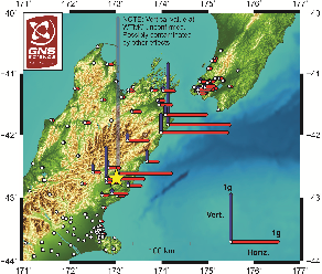
Regional Map of PGA Measurements
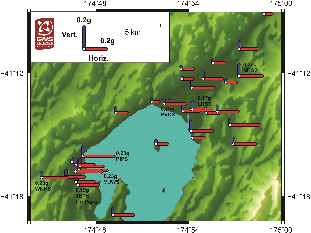
Wellington Map of PGA Measurements
Shakemap Shakemap is a combined model of the estimated ground shaking based on instrumental observations from GeoNet sites and ground motion predictions based on the current fault models. As we get more information from InSAR (Interferometric Synthetic Aperture Radar) the fault models are likely to be updated.
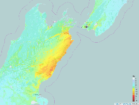
Shakemap
Shakemap also takes into account soil conditions that can amplify shaking in certain areas. This can be seen on the map as areas experiencing higher shaking despite being further from fault rupture.