Severe quakes shake Pōrangahau
Updated: Wed Apr 26 2023 4:40 PM
A magnitude 5.9 earthquake with severe shaking has occurred Wed 26 April at 10:16AM, the earthquake was located within 5km of Pōrangahau and was 22km deep. This was closely followed by a M5.4 aftershock. Both earthquakes were felt widely throughout the North Island.
We received over 22,000 felt reports for the M5.9 earthquake, as shown below:
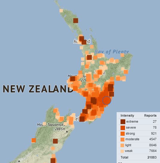
Felt reports from the M5.9 at 10:30AM
Aftershocks
As at 4:30pm on 26 April, there have been 87 earthquakes in the sequence following the M5.9 at 10:16am. The largest aftershock was a M5.4 which occurred 3 minutes following the M5.9.
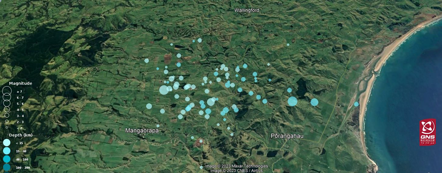
Earthquakes in Pōrangahau today, April 26 2023.
Pōrangahau is located along the Hikurangi Subduction Zone which drives much of the earthquake activity along the East Coast of the North Island. The region also experiences slow slip events – which are earthquakes that happen very slowly (and are not felt).
Scientists are continually doing work to understand more about our seismic activity and the subduction processes behind it. Some of these scientific investigations involve field work, and the deployment of additional sensors and equipment. We’d like to thank all those people that help advance our scientific understanding by hosting our equipment and allowing us access to make observations.
Tsunami
Many people reported feeling the shaking as long or strong and may have evacuated to higher ground. We applaud people that have acted quickly and followed Aotearoa New Zealand’s Long or Strong Get Gone advice. During strong earthquake events, people are advised to head to higher ground if they feel shaking that is long or strong and follow the instructions of their local Civil Defence. In this case the earthquakes did not invoke a tsunami threat.
Landslides
A landslide may be triggered by heavy rain or earthquakes, with homes near hills or steep slopes most at risk. If you live near a hill or steep slope, watch out for cracks or movement that could be a warning sign.
Seen a landslide? You can ‘dob it in.'
Please email us as much of the following as you can supply:
- Date and time of the slip/landslide
- Location – this can be a street address, distance from a landmark or road. Or pin on google earth/maps.
- Size – it would be useful to know if one person could clear the landslide or if heavy machinery would be needed.
- Type – was the landslide made up of rocks falling from a cliff, along a road or was it a flow of material rather than a fall? Was anything damaged?
- Photos – these are very useful for us especially views showing the whole landscape.
You can send your landslide emails to: landslides@gns.cri.nz.
We will keep this news item updated as we have more information to share
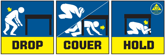
Remember in an earthquake to Drop, Cover and Hold
Remember Long or Strong, Get Gone : If you are near the coast and feel a strong earthquake that makes it hard to stand up OR a weak rolling earthquake that lasts a minute or more move immediately to the nearest high ground or as far inland as you can, out of tsunami evacuation zones.
Know what to do?
The National Emergency Management Agency (NEMA) has a great website with information on
what to do before, during and after an earthquake.
Has your property suffered damage?
If you’ve got damage from the recent earthquake, care for your whānau’s safety first, take photos of any damage,
and call your private insurer. Find out more about insurance and claims on the
Natural Hazards Commission Toka Tū Ake website.
Media Contact: 021 574 541 or media@gns.cri.nz