Minor unrest ongoing at Taupō Volcano. Volcanic Alert Level remains at Level 1
Minor volcanic unrest continues at Taupō Volcano, with ongoing earthquakes and ground deformation. The Volcanic Alert Level for Taupō Volcano remains at 1 (minor volcanic unrest).
The earthquakes and deformation at Lake Taupō have continued since the last bulletin on 28 September 2022. The rate of earthquake activity has varied since May, peaking with over 80 events in a week in early September. The currently weekly rate has dropped noticeably from a plateau of about 20-40 events a week from June to September. Meanwhile our GNSS (GPS) instruments around the lake continue to observe uplift since May at a site on Horomatangi Reef in the centre of the lake.
We have now located 746 earthquakes, mainly at a depth of 4 to 13 km beneath the centre of Lake Taupō since the activity began in May 2022. The earthquakes in the last 2 weeks have been concentrated in the eastern part of the lake. The largest was magnitude 3.3 on October 3. Shown in Figure 1 is the number of earthquakes detected beneath Lake Taupō each week since early 2022.
In addition to seismic activity, GeoNet continuously monitors ground deformation (land movement) around Lake Taupō. Our GNSS (GPS) instruments around the lake continue to observe uplift at a rate of approximately 60 ± 20 mm per year since May 2022 at a site on Horomatangi Reef in the centre of the lake (Figure 2). An independent survey of vertical ground movement around the lake shore on 28 September shows that the Horomatangi Reef area had risen 24 mm since February 2022. This independent verification of analysis of GNSS data gives us a lot of confidence in our ground deformation results.
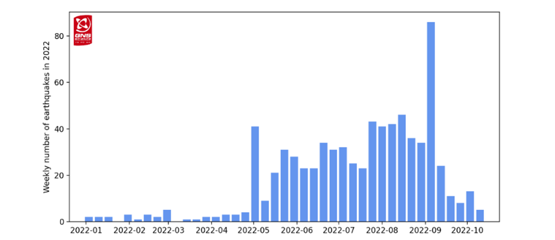
Figure 1: Number of earthquakes detected and located beneath Lake Taupō each week since the start of 2022.
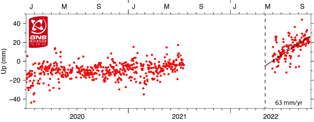
Figure 2: GNSS ground uplift observed at Horomatangi Reef in central Lake Taupō since 2020. The observations represent daily elevations. The scatter in the observations reflects the uncertainty in the calculated daily elevations. The GNSS at Horomatangi Reef was not operating from mid-2021 to mid-2022.
We interpret the ground uplift and earthquake activity to be caused by the movement of magma and the hydrothermal fluids inside the volcano. This activity could continue for the coming weeks or months at varying rates or intensities. While some of the earthquakes may be felt in areas around Lake Taupō, the deformation is currently only detectable by our sensitive ground-based monitoring instruments.
Volcanic unrest is when magma or magma-heated hot water and steam forces its way through the ground beneath a volcano, producing earthquakes and ground movement. There have been 17 previous episodes of unrest at Taupō over the past 150 years and none have ended in an eruption. Check out more about this in our recent Q&A about Taupō volcano.
GNS Science, through the GeoNet programme, continually monitors Taupō volcano and our other active volcanoes for signs of activity. There has been an increase in earthquakes and deformation (ground movement) at Taupō since May 2022 indicating volcanic unrest is occurring. The Volcanic Alert Level (VAL) was raised to Level 1 for Taupō Volcano on 20 September 2022. This was in part based on learnings from research programmes and new knowledge of causes of past unrest at Taupō Volcano, and partly the current data. Watch a video explaining the current activity and change in VAL here.
The Volcanic Alert Level reflects the current level of volcanic unrest or activity and is not a forecast of future activity. While Volcano Alert Level 1 is mostly associated with environmental hazards, potential for eruption hazards also exists. Further information about the Volcanic Alert Levels and what they mean can be found here. More information about caldera unrest can be accessed from this report.
The Tūwharetoa Māori Trust Board (CEO Rakeipoho Taiaroa) is closely involved in discussions as the landowner of Lake Taupō. More information about the Trust can be found at: https://www.tuwharetoa.co.nz/
Although we can’t prevent natural hazards, we can prepare for them – and we should.
During volcanic activity, follow official advice provided by your local Civil Defence Emergency Management Group.
More information about Civil Defence in the Taupō District can be found here.
For information on preparing for earthquakes or responding to volcanic activity, there are guidelines from the National Emergency Management Agency's Get Ready website.
Prepare your home. Protect your whānau.
There’s a lot we can do to make our homes safer and stronger for earthquakes. Toka Tū Ake EQC’s website has key steps to get you started.
Earthquakes can occur anywhere in New Zealand at any time. In the event of a large earthquake: Drop, Cover and Hold.
Find out more about Taupō Volcano
How do we monitor our volcanoes?
Agnes Mazot
Duty Volcanologist
Media Contact: 021 574541 or media@gns.cri.nz