Earthquake activity under Lake Taupō picks up. Volcanic Alert Level remains at Level 0
Since early May 2022, our earthquake monitoring network has recorded an increase in earthquake activity under Lake Taupō. While Lake Taupō sits above the Taupō volcano, the recent earthquakes are not considered to be an indicator that an eruption is on the way. This activity is similar to recent periods of elevated earthquakes activity and ground deformation measured in 2008-2009 and 2019. The Volcanic Alert Level for Taupō Volcanic Centre remains at Level 0.
What’s happening?
The greater Rotorua-Taupō area (Ahi Tupua) is an active volcanic environment, characterised by geothermal areas, caldera volcanoes like Taupō, faults, and frequent small earthquakes. Geologically, this area is part of the greater Taupō Volcanic Zone that extends from Ruapehu to Whakaari/White Island.
Today, Lake Taupō partially infills the caldera (collapse crater), which has formed over the past 30,000 years of volcanic activity from the Taupō Volcanic Centre. The volcano has produced 29 eruptions in the last 30,000 years, most of the eruptions were small (ejecting under 0.5 km3 of volcanic material). Taupō’s last eruption ~232 AD is known as the ‘Taupō eruption’ and was exceptionally large and violent. The Horomatangi Reef area is where the volcano’s vent is. We know that Taupō is still active because it shows signs of what we call ‘volcanic unrest’; small earthquakes, movement of the ground up and down, and changes in the geothermal activity. There have been at least 16 episodes of volcanic unrest at Taupō in the last 140 years.
Often the earthquakes in this area occur as short-lived clusters or swarms. Earthquake swarms are very common in the Rotorua-Taupō area and larger ones will last weeks to months and include many hundreds of earthquakes. The area under Lake Taupō (both inside and outside of the caldera) has been seismically active since 2000, with just over 5,000 earthquakes located by our instruments. Since the start of May 2022, we have located over 300 earthquakes, mostly beneath the central part of the lake. The earthquakes have been clustered in small groups in various locations. The earthquakes this year have ranged in size from about magnitude 1.0 up to 3.6, while 90% of the depths ranged between 4 and 14 kilometres below the surface. The largest earthquake in the sequence has been too small to cause any damage, but almost 300 people living in the area reported feeling it.
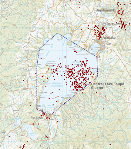
Earthquakes located by GeoNet in the Lake Taupō area from January 1 to July 21, 2022. All earthquakes shown here were located less than 30 km deep. There are just over 300 earthquakes shown on the map.
In the Taupō area, earthquakes occur in several long-lived clusters. In 2022, five clusters have been active, beneath the central part of the lake, north of the lake at Wairakei, Rotokawa, and Ngatamariki, and at Tūrangi. The clusters at Wairakei, Rotokawa, and Ngatamariki are generally interpreted as being related to geothermal power development, and the cluster at Tūrangi is probably caused by typical fault movement. It is the cluster beneath the central part of Lake Taupō, that overlies Taupō volcano, that has seen an increase in activity since May 2022.
Earthquake activity like this is very typical globally and has been common in the Lake Taupō area, occurring every few years. This earthquake activity is similar to recent earthquake episodes in 2008-2009 and 2019 under Lake Taupō. Further back, Lake Taupō has seen swarms and earthquake episodes with many more, and larger, earthquakes that have persisted for much longer. The most active periods of earthquakes occurred in 1895, 1922, 1964-65, and 1983-84.

Earthquakes detected and located in the dashed area outlined in the map each year since 2000. The 2022 sequence of earthquakes stands out, but at this stage has fewer earthquakes than 2008, 2009, and 2019.
As well as recording and locating earthquakes, GeoNet also monitors ground deformation around Lake Taupō. We use several complementary techniques, as ground deformation can occur over different time scales and no one technique is ideal for all of them. Our longest data set is the lake levelling (using the lake surface as a natural spirit level), this has been operating since 1979.
Measurements from a pillar at Horomatangi Reef near the centre of the lake have shown uplift interspersed with little change. The 2008-2009 and 2019 earthquake swarms were accompanied by periods of uplift. The latest observation, in June 2022, showed 12 mm of uplift compared to the previous observation in February 2022. This implies that the increased earthquake activity in the area since May 2022 may have been accompanied by some uplift of part of Taupō volcano, as was also observed in 2008-2009 and 2019.
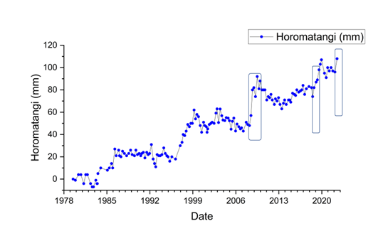
Plot showing ground deformation measured at the Horomatangi Reef site since 1979, highlighting the last 3 episodes of earthquake activity discussed above.
What does this activity mean?
Research and monitoring of the Taupō Volcanic Centre has enhanced our understanding of this volcano. We think that the earthquakes and uplift/subsidence at Taupō are a result of a mix regional deformation processes and the magmatic system under the volcano.
Analysis of the 2008-2009 activity indicated that the behaviour of the Taupō volcano was influenced by a slow-slip event on the Hikurangi subduction zone to the east. Some aspects of the earthquake activity and ground deformation were thought to be trigged by the slow-slip event, while some was from volcanic processes.
The 2019 earthquake swarm was studied by researchers in the ECLIPSE project. That study showed the earthquakes were related to the margins of a relatively solid magma mush zone under the volcano. Magma mush zones, like that identified under Taupō, are a zone of almost solid magma that contains small pools of melt (magma liquid).
It is unclear whether the ongoing earthquakes and uplift is related to regional deformation and/or magma movement. There is a slow-slip event occurring on the Hikurangi subduction zone at this time. However, the lack of significant ground deformation likely rules out large-scale magma involvement. We believe that the 2022 earthquakes are similar to those of 2008-2009 and 2019, and that this has helped inform our view that Volcanic Alert Level 0 is currently appropriate for Taupō volcano.
Changes in the background activity at caldera volcanoes like Taupō are very common. There have been 16 episodes of unrest at Taupō in the past 140 years, all of which quietened back down again. Taupō is an active volcano and earthquakes, and uplift or subsidence will continue to occur in the future. GNS Science through the GeoNet programme continually monitors Taupō and our other active volcanoes for signs of activity.
Although we can’t prevent natural hazards, we can prepare for them – and we should.
For information on preparing for earthquakes or responding to volcanic activity, there are guidelines from the National Emergency Management Agency's Get Ready website.
Toka Tū Ake EQC have information for preparing your home for natural hazards.
Find out more about Taupō Volcano; https://www.gns.cri.nz/Home/Learning/Science-Topics/Volcanoes/New-Zealand-Volcanoes/Taupo-Volcano
How do we monitor our volcanoes? https://www.gns.cri.nz/Home/Learning/Science-Topics/Volcanoes/Monitoring-Our-Volcanoes
Earthquakes can occur anywhere in New Zealand at any time. In the event of a large earthquake: Drop, Cover and Hold.
Our current observations for Taupō volcano are consistent with low levels of volcanic unrest. The Volcanic Alert Level remains at Level 0.
The Volcanic Alert Level reflects the current level of volcanic unrest or activity and is not a forecast of future activity. Volcanic Alert Level 0 indicates the primary hazards are volcanic environmental hazards that may include hydrothermal activity, earthquakes, landslides, volcanic gases, and/or lahars (mudflows).
Further information about the Volcanic Alert Levels and what they mean can be found here.
Agnes Mazot
Duty Volcanologist
Science information - Brad Scott
Media Contact: 021 574541 or media@gns.cri.nz
Footnote: You might notice we've made a tweak to the name of these bulletins - from Volcanic Alert Bulletin to Volcanic Activity Bulletin. We've done this because we think it better reflects the purpose of these bulletins, which can also include more general updates like this one. Any queries, please let us know.