Minor steam and gas emissions continue at Whakaari/White Island. The Volcanic Alert Level remains at Level 2.
Based on observations over the last month, activity at Whakaari/White Island has been limited to minor steam and gas emissions. There have been no significant changes in the active crater area. The Volcanic Alert Level remains at 2
Observations from the most recent monitoring and gas flights show the steam and gas plume continues to originate from the same vent locations as previously observed, with discharge rates in a similar range. Views from the Whakatane webcam show similar conditions prevail at Whakaari/White Island. There has been no evidence of ash emission or eruptive activity from these vents.
Gas emission rates and steam discharge are low, and broadly like earlier observations this year. Measurements from regular monitoring flights have recorded a decline in the temperatures from the larger vents. In March temperatures were higher than 240 °C, while the latest are only 120 °C.
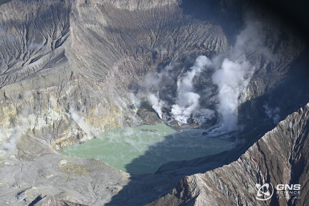
Aerial view of the crater lake and active vents at Whakaari/White Island, 18 July 2023.
Following the failure of our last two surviving on-island monitoring sites, we now have no on-island monitoring capability. We continue to make regular observation and gas measurement flights to monitor the status of the island. We obtain satellite-based ground deformation data approximately every 10 days that allows us to observe ground deformation trends. These are complimented by daily satellite-based Sulphur Dioxide (SO2) emission measurements, although this technique is not as sensitive as our gas measurement flights. Neither of these satellite techniques have detected significant changes in the overall activity at the volcano over the past few months.
The Volcanic Alert Level remains at Level 2 (moderate to heightened unrest) and the Aviation Colour Code remains at Yellow, acknowledging the current level of activity, but also continuing to consider the greater level of uncertainty in our interpretation due to the current lack of consistent, useful real-time data.
As the weather allows, we will continue to undertake gas measurement and observation flights over the island until we can service our on-island equipment and power supplies.
The Volcanic Alert Level reflects the current level of volcanic unrest or activity and is not a forecast of future activity. While Volcanic Alert Level 2 is mostly associated with volcanic unrest hazards (including discharge of steam and hot volcanic gases, earthquakes, landslides, and hydrothermal activity), potential for eruption hazards also exists and eruptions can still occur with little or no warning.
Further information about the Volcanic Alert Levels and what they mean can be found here.
GNS Science’s National Geohazards Monitoring Centre and Volcano Monitoring Group, through the GeoNet programme, continue to monitor Whakaari/White Island for further changes in unrest.
Steven Sherburn
Duty Volcanologist
Media Contact: 021 574541 or media@gns.cri.nz