Minor unrest ongoing at Taupō Volcano. Volcanic Alert Level remains at Level 1.
Minor volcanic unrest continues at Taupō Volcano, with ongoing earthquakes and ground deformation. The Volcanic Alert Level for Taupō Volcano remains at 1 (minor volcanic unrest).
The earthquakes and deformation at Lake Taupō have continued this last week. The earthquake activity started to increase above background levels in May 2022 as did the ground deformation. The rate of seismicity has varied during the last 4 months but remains above typical background levels.
We have reported the ongoing earthquake activity in our last 4 bulletins. The earthquake sequence remains beneath the central part of Lake Taupō and has continued albeit at a slightly lower rate this last week. We have now located approximately 750 earthquakes, mainly at a depth of 4 to 13 km beneath the lake, since the unrest began in May 2022 (see map in Figure 1). The earthquakes in the last week have been concentrated in the eastern part of the lake. Shown in Figure 2 is the number of earthquakes detected per week since early 2022.
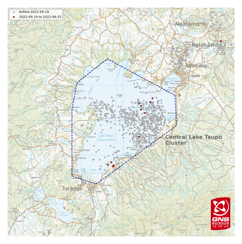
Figure 1: Earthquakes located by GeoNet in the Lake Taupō area from January 1 to September 25, 2022. Most earthquakes shown here were located between 4 and 13 km deep. There are also clusters of small earthquakes at geothermal fields in the Taupō area that are unrelated to the Taupō volcanic unrest. Events since 19th September are shown as red dots.
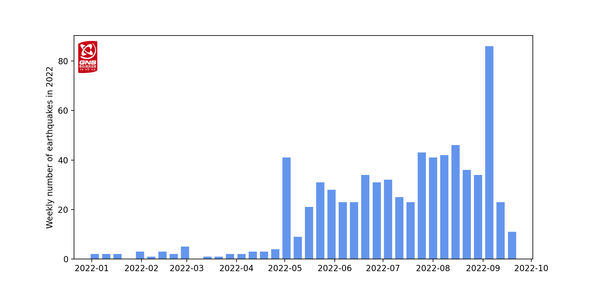
Figure 2: Number of earthquakes detected and located in the dashed area outlined in the map each week since the start of 2022.
In addition to seismic activity, GeoNet continuously monitors ground deformation (land movement) about Lake Taupō. Our GNSS (GPS) instruments around the lake are observing uplift at a rate of 60 ± 20 mm per year since May 2022 at a site on Horomatangi Reef in the lake.
We interpret the ground uplift and earthquake activity to be caused by the movement of magma and the hydrothermal fluids inside the volcano. This activity could continue for the coming weeks or months at varying rates or intensities. While some of the earthquakes may be felt in areas around Lake Taupō, the deformation is currently only detectable by our sensitive ground-based monitoring instruments.
GNS Science, through the GeoNet programme, continually monitors Taupō volcano and our other active volcanoes for signs of activity. There has been an increase in earthquakes and deformation (ground movement) at Taupō since May 2022 indicating volcanic unrest is occurring. The Volcanic Alert Level (VAL) was raised to Level 1 for Taupō Volcano on 20th September 2022. This was in part based on learnings from research programmes and new knowledge of causes of past unrest at Taupō Volcano, and partly the current data. Watch a video explaining the current activity and change in VAL here.
What does this volcanic unrest mean?
Volcanic unrest is when magma or magma-heated hot water and steam forces its way through the ground beneath a volcano, producing earthquakes, ground movement and changes in hydrothermal systems.
There have been 17 previous episodes of unrest at Taupō over the past 150 years (Figure 3). Several of these were more severe than what we are currently observing at Taupō. None of these episodes, or the many other episodes which would have occurred over the past 1800 years before written records were kept, ended in an eruption. The last eruption at Taupō volcano was in 232 AD ± 10 years. The chance of an eruption at Taupō remains very low in any one year.
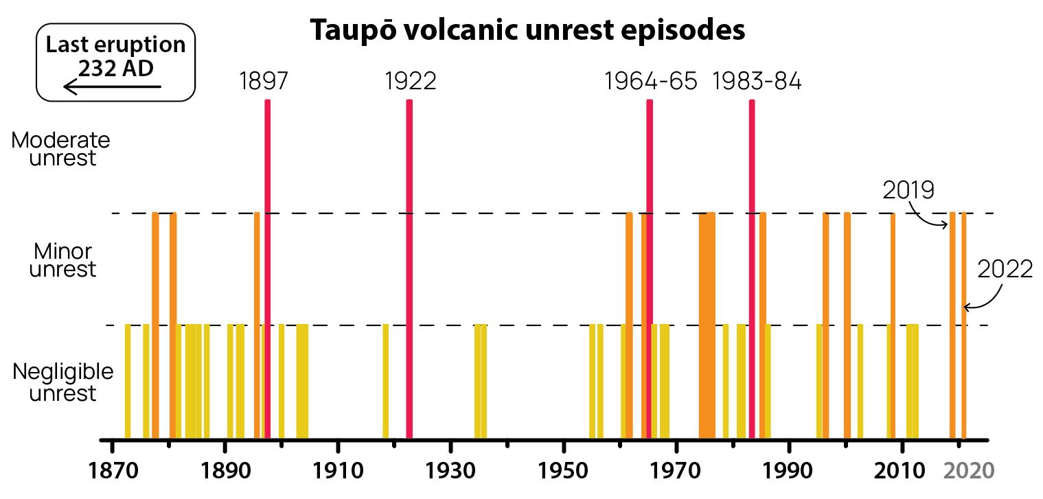
Figure 3: The magnitude of past unrest episodes at Taupō Volcano.
Episodes of unrest are common at calderas around the world. Volcanic unrest at volcanoes like Taupō could continue for months or years and not result in an eruption. If there was increased unrest (not observed to date), then we would see more substantial impacts on the local area. These could include earthquakes with ground shaking and potentially landslides on steep cliffs, especially after rain. Liquefaction can occur in the event of larger earthquakes. Substantially higher levels of ground deformation, 10s of centimetres or metres, would only occur at higher unrest levels, and could have impacts such as damaging underground services. Changes in geothermal activity may also occur with stronger, evolving unrest. This could be beneath the lake or at established geothermal areas in the Taupō area.
The Volcanic Alert Level reflects the current level of volcanic unrest or activity and is not a forecast of future activity. While Volcano Alert Level 1 is mostly associated with environmental hazards, potential for eruption hazards also exists. Further information about the Volcanic Alert Levels and what they mean can be found here. More information about caldera unrest can be accessed from this report.
The Tūwharetoa Māori Trust Board (CEO Rakeipoho Taiaroa) is closely involved in discussions as the landowner of Lake Taupō. More information about the Trust can be found at: https://www.tuwharetoa.co.nz/
Although we can’t prevent natural hazards, we can prepare for them – and we should.
During volcanic activity, follow official advice provided by your local Civil Defence Emergency Management Group.
More information about Civil Defence in the Taupō District can be found here.
For information on preparing for earthquakes or responding to volcanic activity, there are guidelines from the National Emergency Management Agency's Get Ready website.
Prepare your home. Protect your whānau.
There’s a lot we can do to make our homes safer and stronger for earthquakes. Toka Tū Ake EQC’s website has key steps to get you started.
Earthquakes can occur anywhere in New Zealand at any time. In the event of a large earthquake: Drop, Cover and Hold.
Find out more about Taupō Volcano
How do we monitor our volcanoes?
Craig Miller
Duty Volcanologist
Media Contact: 021 574541 or media@gns.cri.nz