No further unusual activity since the M5.6 earthquake beneath Lake Taupō. Volcanic Alert Level remains at Level 1.
More than 600 aftershocks have been recorded following the 30 November 2022 M5.6 earthquake that occurred beneath Lake Taupō. Land movements were detected from our GNSS network of up to 250 mm as a consequence of the earthquake. Field teams have been measuring lakeside slumping and inundation distances of the small tsunami, along the lake shore. No further unusual activity has been observed and the minor volcanic unrest at Taupō volcano continues. The Volcanic Alert Level remains at 1.
Since May, earthquake activity associated with Taupō volcano unrest continues. The M5.6 earthquake on 30 November was one of the largest recorded in Lake Taupō. Following that earthquake, there have been more than 600 aftershocks located by GeoNet. The number of aftershocks is typical following an earthquake of this size. Ground movement associated with the earthquake has been measured by our sensitive GNSS positioning instruments in and around Lake Taupō. The instrument at Horomatangi has shown 250 mm of horizontal movement (towards the south-east), which is the largest ever recorded ground movement at this location. GNSS stations onshore are recording a much smaller movement (~10 to 20 mm) associated with the earthquake. Further analysis of this data set is underway.
Experts are assessing earthquake-related tsunami in the lake that occurred because of the M5.6 earthquake. This caused run up along the lakeshore at several locations, mostly focussed on the northern end of Lake Taupō. Our field teams have been using drone footage and surveying techniques to measure localised lake shore slumping and tsunami inundation. Locations of investigation have been guided by public information along the lake shore. The position of pumice strandlines at Wharewaka Point appears to show the largest tsunami inundation, measured at ~40 m inland. Wave action is likely the result of at least one tsunami, however, we are still assessing their causes. More analysis of existing data, coupled with additional field survey results, should enable our experts to develop models of what happened.
Seismic activity appears to be a main shock-aftershock sequence that has punctuated an otherwise steady unrest record to date. The last felt aftershock was a M4.1 event on Dec 1 at 1.53pm. The magnitude and rate of aftershocks has started to decline but is expected to continue for several weeks. Within the next 7 days, there is a 7% chance of one or more earthquakes of M5 or larger. Within the next 30 days, there is a 16% chance of one or more earthquakes of M5 or larger. Read more on the earthquake forecast and other facts on the earthquake here.
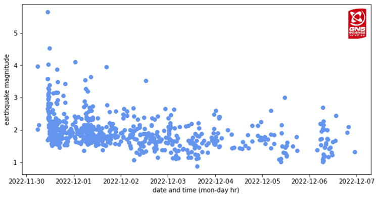
Aftershock timeseries since the M5.6 on November 30. Note the steady decline in the number of aftershocks. Further moderate magnitude earthquakes remain possible; however, their likelihood diminishes over time.
The recorded ground deformation and earthquake activity is likely caused by magma and hydrothermal fluids deep beneath Taupō volcano. This period of unrest is one of at least 17 previous episodes at Taupō over the past 150 years. None of those unrest periods resulted in an eruption and the activity observed last week appears no different. Check out more about this in our recent Q&A about Taupō volcano.
To assess any broad-scale change at the volcano, we have sampled the geothermal gases at Motuoapa. That area appears unchanged from our last sampling survey in September. We are proceeding with installation of additional seismic and GNSS instruments to enhance our data capture. When the weather allows, we will be conducting a lake levelling survey that will complement the results from our analysis of GNSS data.
Previous unrest at Taupō has continued for months to years. Based on this history, the current unrest period could continue for many weeks to months at varying rates or intensities.
Moderate to large earthquake activity can cause landslides into the lake, slumping of steep under water slopes and displacement of the lake floor due to faulting, all of which can generate unusual wave activity. Tsunami or unusual waves in lakes are also known as seiches. If people feel strong ground shaking, hear a loud boom, or notice unusual lake conditions, they should move away from the lake shore.
We understand that the earthquakes and tsunami recorded over the last week can be unsettling for some, but the activity we have seen is within the bounds expected during a period of minor unrest at Taupō. We continue to closely monitor the volcano, and when we have more information, we will share this.
The Volcanic Alert Level reflects the current level of volcanic unrest or activity and is not a forecast of future activity. While Volcano Alert Level 1 is mostly associated with environmental hazards, potential for eruption hazards also exists. Further information about the Volcanic Alert Levels and what they mean can be found here. More information about caldera unrest can be accessed from this report.
Geoff Kilgour Duty Volcanologist
Media Contact: 021 574541 or media@gns.cri.nz
The Tūwharetoa Māori Trust Board (CEO Rakeipoho Taiaroa) is closely involved in discussions as the landowner of Lake Taupō. More information about the Trust can be found at https://www.tuwharetoa.co.nz/.
Although we can’t prevent natural hazards, we can prepare for them – and we should.
Know what warning signs to look out for, so you can act quickly. Drop, Cover, and Hold during a large earthquake. If it is Long and Strong, Get Gone! People near the lake front should move to higher ground as soon as it is safe to do so, especially if they hear loud noises or see unusual lake action during earthquake activity.
During volcanic activity, follow official advice provided by your local Civil Defence Emergency Management Group.
More information about Civil Defence in the Taupō District can be found here.
For information on preparing for earthquakes or responding to volcanic activity, there are guidelines from the National Emergency Management Agency's (NEMA) Get Ready website.
Prepare your home. Protect your whānau.
There’s a lot we can do to make our homes safer and stronger for earthquakes. Toka Tū Ake EQC’s website has key steps to get you started.