Level of unrest continues to decrease at Mt Ruapehu. The Volcanic Alert Level is lowered to 1.
New Crater Lake chemistry data, low volcanic tremor levels and a stable warm lake temperature indicate a decline in the level of volcanic unrest at Mt Ruapehu. In consequence of these, the Volcanic Alert Level is lowered to Level 1 and the Aviation Colour Code changes to Green.
Analyses of water samples from Crater Lake (Te Wai ā-moe) have now confirmed there has been little recent chemical interaction between magma (new molten rock) and the hydrothermal system controlling the composition, level, and temperature of the Crater Lake. The period of strong volcanic tremor, from mid-March to early-June 2022 has declined to near background levels and generally lower gas emission rates are being recorded. Short-lived pulses of gas are still reaching the surface. When taken together these observations are consistent with a decline in volcanic unrest at Mt Ruapehu and the Volcanic Alert Level is now lowered to Level 1.
Over the last week, volcanic tremor has remained weak at Mt. Ruapehu. It has now been over 20 days since the last higher tremor levels. Crater Lake (Te Wai ā-moe) temperature decreased from a high of 40 °C in early-May to 21 °C on June 14, and in the following two weeks recovered to 25 °C. The temperature has stabilised or fallen slightly this last week, currently the temperature is 24 °C consistent with heat flow into the lake of about 100 MW.
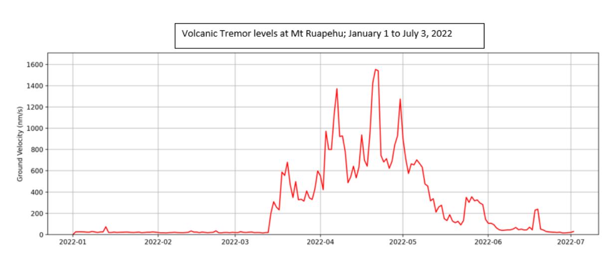
Plot showing the level of volcanic tremor at Mt. Ruapehu, 2022
Despite the decline in volcanic unrest the potential for eruptive activity remains. Over the last 2-3 months a magmatic intrusion has occurred inside the volcano, increasing heat and gas flow into the hydrothermal system associated with the Crater Lake. Our data indicate that the intrusion has stalled or stopped moving. Whilst this means that the current unrest episode has ended, the presence of recently stalled magma in the volcano suggests that a sudden resumption of activity would be more possible than the last time Ruapehu was at Volcanic Alert Level 1.
The most likely outcome of the ongoing but weaker unrest is no eruption or minor eruptive activity, confined to the lake basin. If this did occur, it is possible to generate lahars (volcanic mudflows) in the Whangaehu River.
The next most likely scenario should unrest activity increase again remains an eruption that impacts the summit plateau with volcanic surges. That event could generate lahars in multiple catchments, like what was seen after the September 2007 eruption. An eruption of this size would cause life-threatening hazards on the summit plateau and in valleys impacted by lahars.
The chance of a prolonged eruptive episode or a larger eruption, with wider ashfall impacts such as occurred in 1995-96, is now similar to before the start of elevated unrest in March 2022.
The low levels of volcanic tremor, the Crater Lake chemistry data, lower but short-lived pulses of gas and a stable Crater Lake temperature are consistent with a decline in the level of volcanic unrest at Mt Ruapehu and therefore the Volcanic Alert Level is lowered to Level 1. The Aviation Colour Code changes to Green (from yellow).
Mt Ruapehu is an active volcano and has the potential to erupt with little or no warning when in a state of minor volcanic unrest.
The Volcanic Alert Level reflects the current level of volcanic unrest. The Volcanic Alert Level should not be used to forecast future activity. Volcanic Alert Level 1 indicates the primary hazards are those expected during volcanic unrest: steam discharge, volcanic gas, earthquakes, landslides and hydrothermal activity. While Volcano Alert Level 1 is mostly associated with environmental hazards, potential for eruption hazards also exists and eruptions can still occur with little or no warning. Volcanic Alert Levels 3, 4 and 5 are reserved for eruptions with varying impact distances.
For information on access to the Mt Ruapehu area, please visit the Department of Conservation’s websites on volcanic risk in Tongariro National Park and follow the DOC Tongariro Facebook page for further updates.
For information about responding to volcanic activity there are guidelines from the National Emergency Management Agency.
GNS Science and its National Geohazards Monitoring Centre continue to closely monitor Mt Ruapehu for further changes.
Agnes Mazot,
Duty Volcanologist
Media Contact: 021 574 541 or media@gns.cri.nz