Recent earthquakes under the summit of Ruapehu – unrest remains low
A recent cluster of earthquakes has occurred beneath Ruapehu’s summit. All monitoring data at Ruapehu indicates that volcanic unrest remains at minor levels. The Volcanic Alert Level at Mt Ruapehu stays at Level 1.
Earthquakes regularly occur in the Tongariro National Park, and towards the southern portion around Ruapehu, we often record them near Waiouru and National Park Village. There are two broad styles of earthquakes at volcanoes: volcanic earthquakes (which includes tremor) that are directly related to the movement of fluids (magma and/or the hydrothermal system), and tectonic earthquakes which result from rocks fracturing (movement on small faults).
From 30 December 2021, we have recorded a sequence of tectonic earthquakes located beneath Ruapehu’s summit area. So far, there have been at least 30 distinct earthquakes in this sequence. When compared to historical records, the number of earthquakes with epicentres closely confined to the summit area, is unusual. While these earthquake clusters are uncommon, none of our monitoring data suggests that the volcano is exhibiting increased levels of activity.
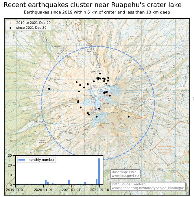
Plot of the location and number of earthquakes beneath the summit area at Ruapehu since 2019, with earthquakes since 30 December 2021 highlighted
There has been no observable response from other continuous monitoring data such as Crater Lake (Te Wai ā-moe) temperature, lake level, or volcanic tremor. Therefore, our current assessment is that a relatively deep stress release has occurred below the volcano, but this has not affected the volcano's hydrothermal system.
Our team will be conducting a scheduled gas flight and will sample Ruapehu’s Crater Lake (Te Wai ā-moe) in the coming days, weather permitting.
The Volcanic Alert Level stays at Level 1 which reflects the current level of volcanic unrest. The Volcanic Alert Level should not be used to forecast future activity.
The Aviation Colour Code remains at colour Green.
Mt Ruapehu is an active volcano and has the potential to erupt with little or no warning when in a state of volcanic unrest.
Volcanic Alert Level 1 indicates the primary hazards are those expected during volcanic unrest: steam discharge, volcanic gas, earthquakes, landslides and hydrothermal activity. While Volcanic Alert Level 1 is mostly associated with environmental hazards, eruptions can still occur with little or no warning.
For information on access to the Mt Ruapehu area, please visit the Department of Conservation’s websites on volcanic risk in Tongariro National Park and follow their Facebook page for further updates.
GNS Science and the National Geohazards Monitoring Centre continue to closely monitor Mt Ruapehu for further changes.
Geoff Kilgour Duty Volcanologist
Media Contact: 021 574 541 or media@gns.cri.nz