Science Alert Bulletin RAO-2006/02 - Raoul Island Volcano
23 March 2006, 10:00 am - Raoul Island update and overview
Raoul Island is an active volcano with a long eruptive history (15 eruptions in the last 3600 years, with three in the recent historic period: 1814, 1870 and 1964). All of these eruptions except 1964 have been magmatic in nature and activity has occurred in both the Raoul and Denham Bay calderas.
On the evening of Sunday March 12 earthquakes began near Raoul Island. More than 200 earthquakes were recorded in the first 24 hours, with many of the larger events felt on the island. Earthquakes continued throughout the week, but the numbers of earthquakes gradually reduced. Without any warning an eruption began from Green Lake at 8.21 am on Friday 17 March (no water level or temperature changes were observed, even only 24 hours before the eruption). Based on data from the seismograph on the island, the eruption appears to have continued for up to 30 minutes, although the most intense part of the eruption lasted for only 5 to 10 minutes. Following the eruption, the rate of earthquake activity doubled, but has since reduced to 10 to 20 per day. Details of recent observations are reviewed below.
Alert Status
The Volcanic Alert level remains at Level 2.
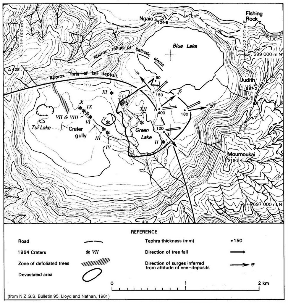
Topographic map of Raoul Island
Volcano monitoring of the crater lakes within Raoul Caldera started after the 1964 eruption, as these showed a response before that event. The focus of monitoring and recent investigations has shown there to be a long-lived hydrothermal system in existence. There are low temperature (boiling point) fumaroles in the vicinity of Green Lake, and minor seepages of hydrothermal brine from the system (boiling hot springs) along Oneraki Beach, outside of the caldera. The gases have strong hydrothermal signatures (as opposed to proximal magmatic). As such, they do not suggest single-phase vapour transport directly from a magmatic source to the surface, but rather are indicative of the presence of boiling hydrothermal brine at depth. We have no quantitative data from Denham Bay (offshore Denham Caldera), but know of boiling point (100°C) steaming ground on the steep crater walls, and gas and water seeps in the sea. Historical observations of volcanic eruptions from this caldera (and Raoul Caldera) point to the likely existence of a sizeable active system residing there.
Post eruption we have observations from still and video footage taken on the afternoon of 17 March and during an aerial inspection on 21 March.
The 17 March images show many new craters and reactivation of existing 1964 craters. The main steam columns were derived from Crater I, Marker Bay and Crater XI (refer to the accompanying diagram). There are many new craters and fumarolic activity near the mouth of Crater Gully and the stream that drains from Crater V. The area north-west of Bubbling Bay where there was a fumarole, is now a crater about 20 to 30m across. In the main body of the lake there were two areas of strong upwelling, one near the end of the peninsula south of crater XII which has been erupted away. There are now jagged rocks showing in the lake, where it was formerly 2 to 4 metres deep. There is also a new feature about 200 to 300 metres north of Green Lake Crater XII, forming a moat near the edge of the crater floor, and there is a vigorous vent active in it. Many of the steep crater margins have collapsed post eruption (fresh landslides). The eruptions have blown over mature trees out to about 200 metres and deposited dark grey hydrothermal mud and ballistic blocks (i.e. large blocks). The water level of Green Lake did not appear to have risen at the time of the 17 March observations.
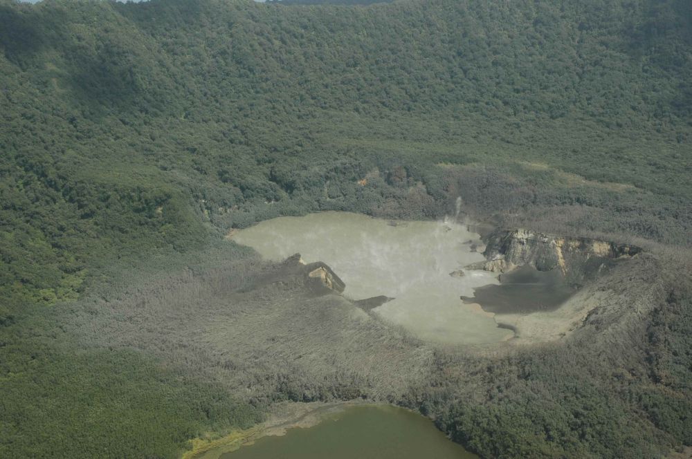
Photo of Green lake - Raoul Island
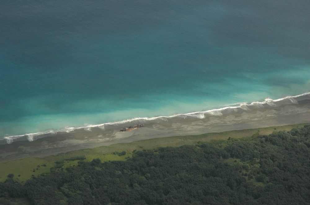
Photo of Denham Bay - Raoul Island
On 21 March an aerial inspection was made from a RNZAF Orion, allowing excellent views of both Raoul and Denham Bay calderas. Steam/fume discharge from the vents had declined significantly owing to a dramatic (6 to 8 metre) rise in Green Lake water level, and consequent drowning of most of the active vents. The lake level does not appear to have reached overflow level. Landsliding and collapse has also blocked Crater I. Vigorous upwelling and gas discharge is still obvious through Green Lake, which appears very warm. There is no evidence of further eruptions since 17 March. There was no evidence that any activity has occurred from the 1964 craters north-west of crater gully (i.e. craters IV, III, VI, through to X), but many new craters have formed at the mouth of this gully where hot bare ground has been present. There is a possible suggestion of a north-easterly trend through the vents from Crater Gully to north-east of Crater XII. In 1964 the craters aligned along 3 parallel fractures that tended north-west. In Denham Bay we were able to observe a weak plume of discoloured water approximately coincident with the vent area. There is evidence of hydrothermal seepage along most of the beach (milky discoloration indicating mixing of hydrothermal brine and seawater). There were also discharges in the rocky bay half way between Hutchison Bluff and the north-west end of Denham beach (these have not been reported before to our knowledge). If these are confirmed as hydrothermal seepages, they represent a significant rise in the surface of the hydrothermal fluids in the system, as observed in the caldera.
Earthquake activity began near Raoul Island on the evening of Sunday 12 March and still continues. More than 200 earthquakes were recorded in the first 24 hours, with many of the larger events felt on the island. Earthquakes continued throughout the week, but at a gradually reducing frequency. Most of the earthquakes were tectonic-style rock shearing events with a few (about 20 in all) showing a hybrid characteristic in that they had low frequencies present in their codas. No purely low-frequency earthquakes or volcanic tremor, indicative of the movement of magmatic or hydrothermal fluids, was observed. By the Friday morning eruption (17 March) the rate of earthquake activity had declined to fewer than 50 per day.
Strong sequences of earthquakes at Raoul Island are not common, but have occurred on several occasions in the past. In November 1964 a strong sequence of earthquakes, the largest of magnitude 5.9, occurred over a 10 day period prior to the eruption at Green Lake. This sequence was also accompanied by very strong volcanic tremor that indicated that molten magma was rising beneath Raoul Island, a 6 metre rise in the level of Green Lake, ground cracking, and by the appearance of new hot springs. In comparison, the largest earthquakes prior to Friday's eruption had a magnitude of about 3.5 and daily observations about Green Lake showed no changes of any kind.
In March 1993, a sequence of several hundred earthquakes were recorded over a period of two weeks, with the largest having a magnitude of 4.3. No indications of any magma movement were observed, but following the earthquakes there was a 1.2 metre rise in Green Lake. There was also an earthquake sequence near Raoul Island in 1989, again with no eruption. In addition, over the past 15 years there have been at least 5 occasions when low-frequency volcanic earthquakes or volcanic tremor have occurred without any associated eruption.
In summary the activity continues at Raoul, although there have not been any further eruptions since the explosions of 17 March. There has been a significant response from the volcano hydrothermal system, both within Raoul Caldera and Denham Bay. The more western of the 1964 craters have not been active. Further eruptions, as the hydrothermal system adjusts to the increased fluid pressure, remain possible and access to the active crater area should be restricted to the margins of the areas affected to date. The Green Lake crater should not be entered at this time.
Steve Sherburn
GeoHazards Duty Officer