Why so many earthquakes?
In the first six months of 2023 we located almost eleven thousand earthquakes in and around Aotearoa New Zealand. So, is that a lot for us? It’s actually pretty spot on! On average, we locate over 20,000 earthquakes a year at GeoNet. Around 100-150 of these quakes are large enough to be felt – the others we only know about because they are recorded by our sensitive seismographs.

10,957 earthquakes located by GeoNet from Jan-June 2023
The map of New Zealand above shows earthquakes occurring along a relatively straight line that transcends both the North and South Islands. This is because New Zealand is located on the boundary of two of the world’s major tectonic plates – the Pacific Plate and the Australian Plate.
These plates push against each other, causing stress that builds up. The stress is released is through movement on faults, causing earthquakes.
While that line of earthquakes may look pretty straight and simple, the dots are actually tracing out some of our several hundred active faults. That’s the reason we monitor all of the small, unfelt events: each of those 10,957 quakes is teaching us about where those fractures are and how they are moving, so that we better understand our earthquake risk.
Watch an animation to see how the plates interact below us:
Ever wondered how many earthquakes your local area experiences?
We have an awesome interactive tool that allows you to search, and build queries, using our entire earthquake catalogue - which goes back to the 1930’s! It’s called Quake Search.
Quake Search lets you search a particular area, date and size of earthquakes. Below is an example of all the earthquakes located in April 2022 on the left, and earthquakes around Palmerston North in the past year, on the right.
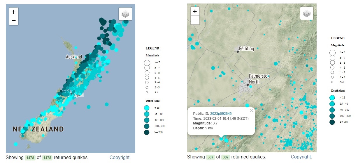
Earthquakes located in April 2022 on the left, and earthquakes around Palmerston North in the past year, on the right.
Some helpful hints to use QuakeSearch:
Date: Select the time frame, note the data is in UTC (universal time) which is currently 12hrs behind NZ time
Location: Zoom into the area of NZ you are interested in, select a region or enter coordinates
Depth & Magnitude: If you are interested in quakes of a certain size, or depth, enter that in here
Output: You can choose to see the quakes on the map, or you can select ‘build Query’ where you can choose the output including CSV – spreadsheet, and KML - which will open in Google Earth.
Need more help? Try the guide for Quake Search- it’s the ‘?’ at the bottom right of the page.
The earthquake catalogue is where all the technical information about earthquakes is stored. New Zealand has about 20,000 earthquakes a year, so that is a huge amount of data, and you can explore it all!
Like numbers?
We also have a handy page with earthquake stats you can view.
Earthquakes can occur anywhere in New Zealand at any time. In the event of a large earthquake: Drop, Cover and Hold.
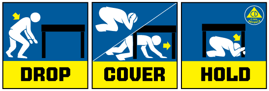
Drop, Cover and Hold
Remember Long or Strong, Get Gone : If you are near the coast and feel a strong earthquake that makes it hard to stand up OR a weak rolling earthquake that lasts a minute or more move immediately to the nearest high ground or as far inland as you can, out of tsunami evacuation zones.
Know what to do?
The National Emergency Management Agency (NEMA) has a great website with information on what to do before, during and after an earthquake.
Prepare your home. Protect your whānau.
There’s a lot we can do to make our homes safer and stronger for natural disasters. Toka Tū Ake EQC’s website has key steps to get you started.
Media Contact: 021 574 541 or media@gns.cri.nz