
Kaikōura two years on: Playing the long game with landslides
Hazards from landslides triggered by the M7.8 Kaikōura quake will continue to pose a threat for many years as loose sediment remains in the hills and valleys. Two years on, our scientists are still studying the effects of this huge quake.
Since the quake, GNS Science engineering geologists have mapped 24,000 of the most significant landslides of the tens of thousands of landslides caused by the quake over an area of about 10,000km2. To map these, they’ve used a combination of photographs, and satellite and radar images from before and after the earthquake.
The largest individual landslide was the one that blocked the Hapuku River. It involved 12 million cubic metres of hillside collapsing into the river and forming a new lake 400m long, 100m wide and 35m deep.
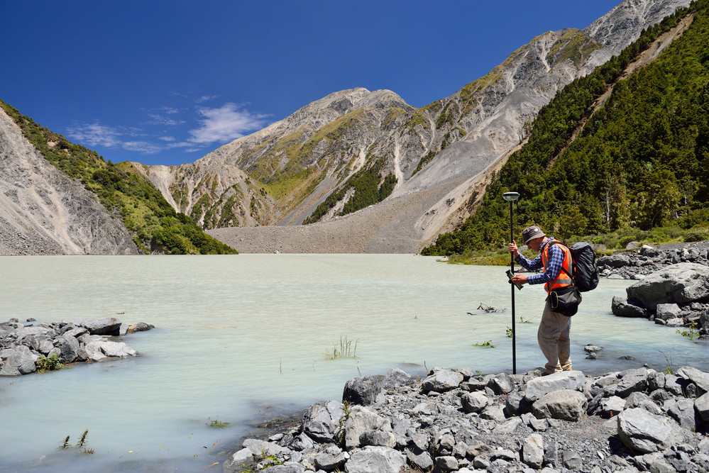
Hapuku River dammed by landslide
A Kaikōura-scale landslide event happens only once every decade or two – probably the best-known other examples are Cyclone Bola in 1988 and the Manawatu Floods in 2004 – and so our scientists have grabbed the opportunity to learn as much as they can.
“The data we have collected and the observations we’ve made is helping to get a better understanding of how to protect road and rail and other infrastructure,” says GNS Science engineering geologist Sally Dellow.
“Our research is also helping us understand how long it takes for a landscape to stabilise after a traumatic event like this. It is also giving an insight into what might happen in future earthquakes in Wellington and on the Alpine Fault.”
Following the Kaikōura quake many rivers were dammed by landslides, creating a potential threat of downstream flooding if the dams broke suddenly. However, a series of heavy rain events in the past two years has eroded most of the dams allowing backed-up water to drain away harmlessly.
The biggest residual threat is the large amount of loose sediment in the hills and valleys of North Canterbury and Marlborough. Future heavy rain events or large earthquakes could continue to move big volumes into rivers potentially causing a series of hazards all the way to the coast. Possible threats include sudden changes to the course of rivers and over-topping of flood banks.
We were given a pretty good insight into these hazards early this year when ex-tropical cyclone Gita dumped heavy rain on the upper South Island and moved large volumes of gravel through rivers. State Highway 1 and the Christchurch-to-Picton rail line were both buried in gravel in several places.
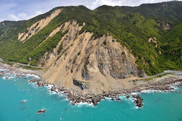
Landslide blocking SH1
Over the past three decades, landslides have cost New Zealand an average of $300 million a year. Kaikōura was exceptional. The rebuilding of State Highway 1 and the Canterbury-to-Picton rail line has cost in excess of $1 billion. Tourism revenue has been affected and freight costs were pushed up sharply by the diversion of Christchurch-to-Picton road and rail traffic.
If you'd like to read more about the landslide dams caused by the Kaikōura quake, then go here.
Tomorrow, on the two-year anniversary, we take a look at the human side of earthquakes and at community resilience. We’ll be posting an article each day this week.
Read yesterday’s here: Kaikōura two years on: The changed landscape