
What’s in a Magnitude?
You might have noticed in the minutes following an earthquake, the magnitude and its precise location may change. Usually these changes are slight, but for larger, more complex events like the 2016 Kaikōura earthquake, they could be more significant. We explain why this happens and take a closer look at the different types of magnitudes there are.
Over eleven years ago all larger/felt earthquakes were manually located by a duty officer before they were posted to our website, this could sometimes take over twenty minutes! We then introduced our automated system which enabled earthquakes to show on our website (and app) only minutes after shaking started.
Currently earthquake information is pushed out to the website and app before it is reviewed. With our team of Geohazard Analysts (GHAs) in the National Geohazards Monitoring Centre, an update to the automatic information is speedy and usually done within minutes.
Why do magnitudes change?
The size of an earthquake is often described using magnitude, which is the amount of energy released during an earthquake.
The earthquake information you see first on our website and app is located and published automatically; you will see this under Earthquake Details labelled as ‘automatic’. As more data from the earthquake comes in, our automated system constantly refines the earthquake location.
Within minutes, one of our Geohazard Analysts will be looking at the earthquake and once they confirm it's a real event, the earthquake will be labelled as ‘preliminary’ status. Our Geohazard Analysts will continue to refine the preliminary information until they have sufficient data to confirm the event. This sometimes takes time as they are waiting for enough data from sensors at a range of distances from the earthquake (including some international sensors). This is usually within minutes but can sometimes take longer.
Using the M6.0 earthquake in the South Island on 20 September 2023 as an example, the earthquake was automatically posted to our website as a M5.4. Our Geohazard Analysts then immediately reviewed it, and as more data came in the earthquake size moved around a bit, from M5.9 to M6.4, under ‘preliminary’ status, before we had a final ‘best’ label of M6.0. You can view how an earthquakes size and location changes by clicking on its history tab.
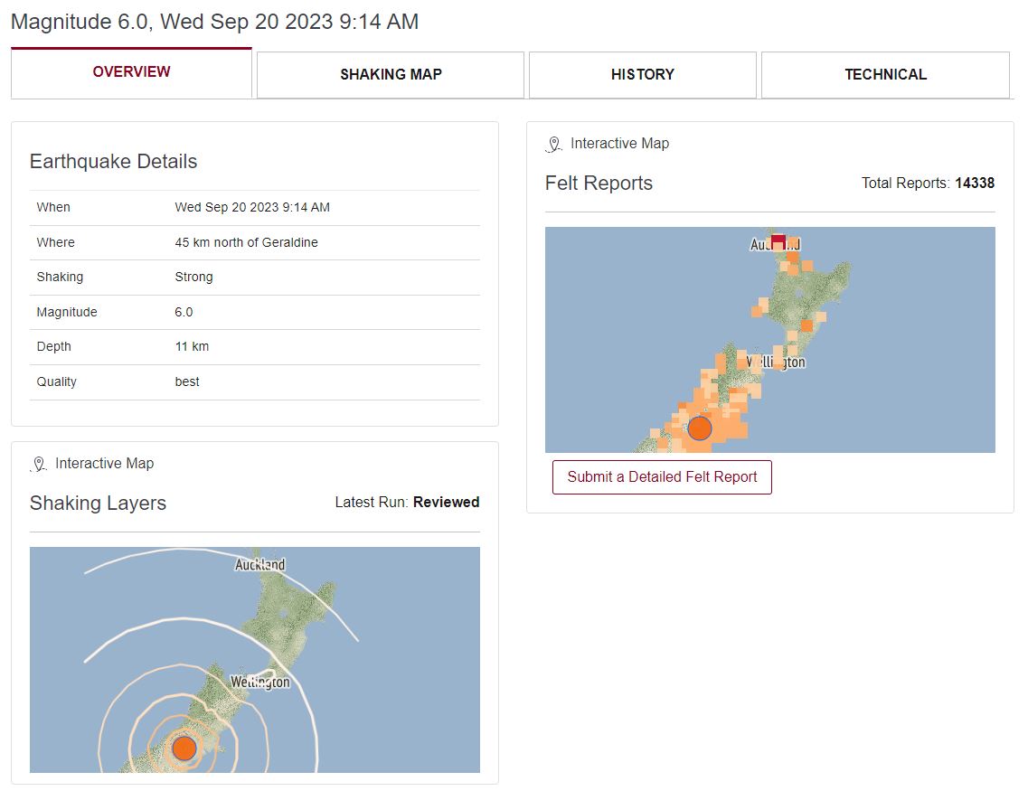
2023 M6.0 South Island earthquake with ‘best’ quality
Sometimes, for large or complex events, there can be additional changes hours or even days later as the event is further reviewed and refined by experts with additional data. You can see all these changes by clicking on an earthquake’s history tab and looking at its Location History.
Magnitude and Shaking Intensity
Although we describe the size of an earthquake using magnitude, the way that the energy released in an earthquake is felt at the surface is affected by several things, this is where intensity comes in.
Intensity of shaking from an earthquake is a descriptive measure about the perceived shaking on the surface of the earth and is a very helpful indicator of the shaking that people and infrastructure may have experienced. Intensity will vary based on factors like how close you are to the earthquake, the ground conditions (e.g. are you on solid rock or softer soils), and the type of building you are in, so people’s experience of an earthquake of a specific magnitude may be quite different!
The newly released Shaking Layers maps on our website illustrate the intensity of ground shaking caused by earthquakes in different parts of the country. The maps incorporate data from ground motion sensors and are automatically produced within 10 to 20 minutes of a magnitude 3.5 or greater earthquake. Users can zoom into the map and get a measure of how strong the shaking was in any area. With shaking intensity, you can see how the same earthquake is felt differently across the motu.
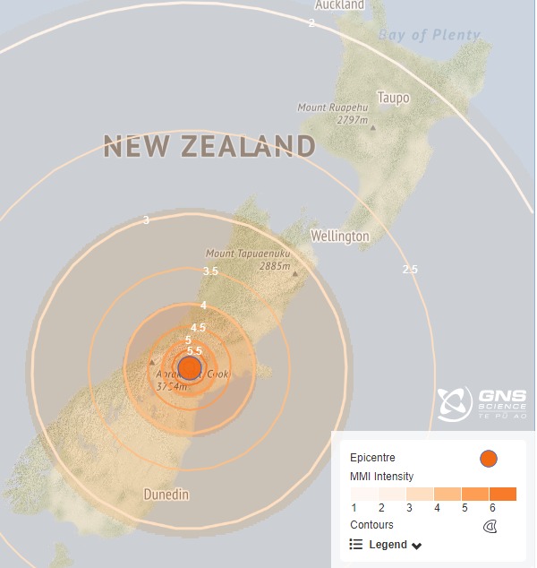
Shaking Layers map from 2023 M6.0 earthquake
Why are overseas agencies magnitudes sometimes different?
You may also notice international agencies such as the United States Geological Survey (USGS) or Geoscience Australia have published the same earthquake but with a different magnitude to ours. The main reason for this is that there are many different types of magnitude which use different methods to estimate size (you can read more on this in the next section).
On the GeoNet website, the magnitude published is usually the summary magnitude, which is a combination of several different magnitude types that we can estimate most quickly. The different magnitude types and the different networks of other agencies provide important perspective on earthquakes in New Zealand, especially in locations like the Kermadecs where it is difficult to get broad sensor coverage. If you click on the ‘technical’ tab on an earthquake, you will see the different magnitudes used.
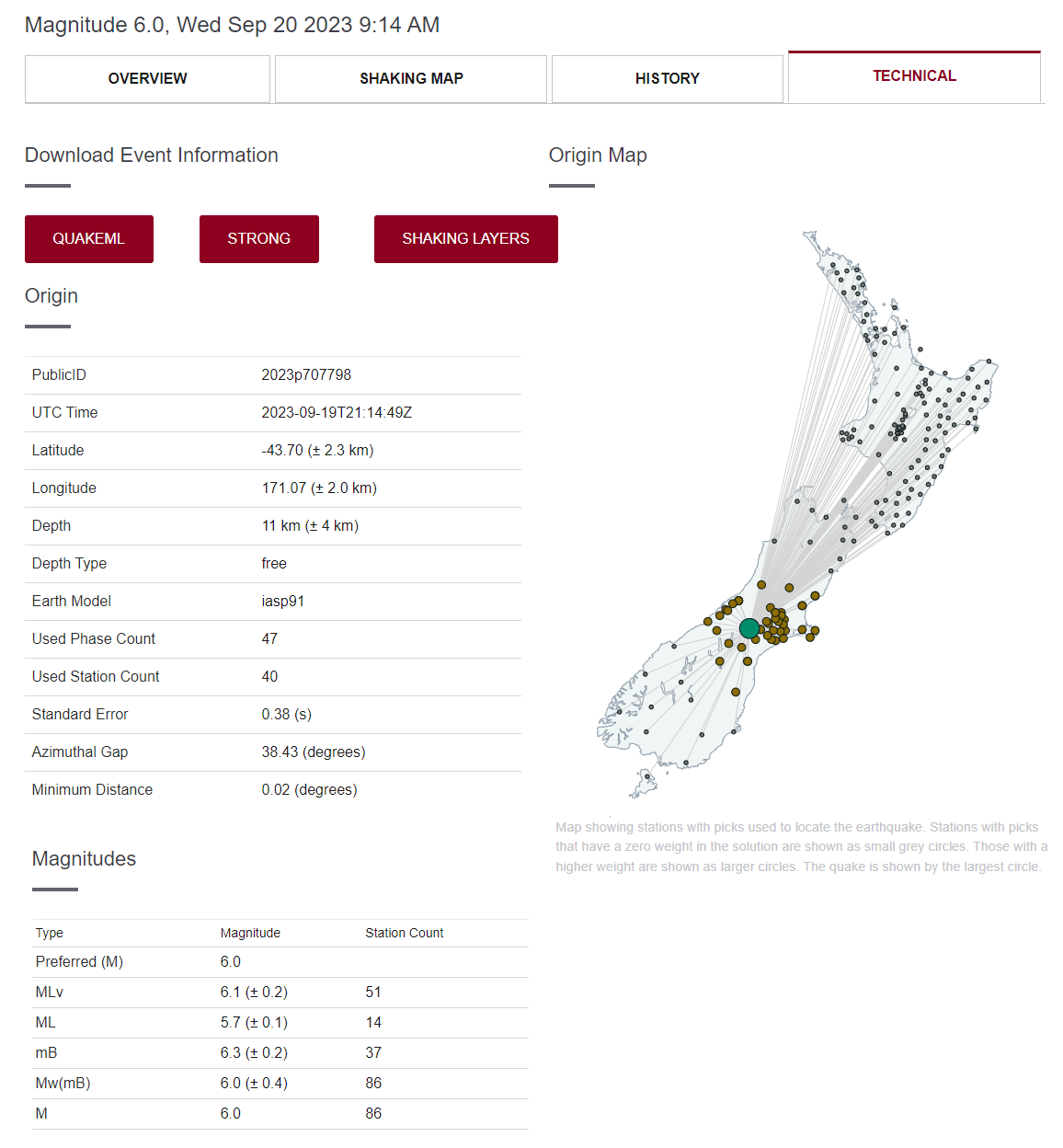
‘Technical’ tab for M6.0 earthquake showing the stations used to calculate the magnitudes.
A deeper look into different types of magnitudes
Faults that could create earthquakes range in size from less than a metre long to more than 1000 kilometres for the largest earthquakes, and therefore the size of earthquake signals, how far they travel, and how well they are detected vary significantly. Because of this huge range, there is no one way to measure the magnitude of an earthquake that will capture all earthquakes. Seismologists have developed several ways to measure different aspects of an earthquake (different magnitude scales) which allows them to get the best idea of the size of the event and to be able to make direct comparisons with the magnitudes put out by other agencies.
The signals recorded from an earthquake can be thought of as comparable to music, with signals from earthquakes of different sizes being comparable to different types of music with various frequency content, for example, music with a lot of high frequencies and very little bass, or music with a lot of bass compared with high frequencies. The larger an earthquake is the more bass (low frequency energy) it has.
Most earthquake magnitude scales measure the amplitude (height) of a recorded signal at a particular frequency and certain part of the signal, with the idea being the larger the earthquake is the larger the amplitude will be. This would be like turning up the volume of the music at that frequency. For example, Richter magnitude, which seismologists call ‘local magnitude’, measures the amplitude of the high frequencies of the early part of the signal, and as the earthquake gets larger it would be like ‘turning up the volume’ at that portion of the signal.
Most magnitude scales measure the amplitude of different parts of the earthquake signal at higher frequencies, and each of these magnitudes are meaningful and tell us something about the characteristics of the earthquake, even if they give different values. This means that none of the magnitude values are ‘wrong’, even if the values are different. However, most magnitude scales have a significant drawback: they don’t measure low frequencies. As earthquakes get very large, around magnitude greater than about 7.0 – 7.5, the high frequency part of the signal gets maxed out – the ‘volume’ is turned up as high as it will go. For these earthquakes the low frequency part of the signal is what is increasing – in other words, there is more and more bass. As the earthquakes get larger the extra energy is pushed into increasingly lower frequencies – in other words, there is increasing bass at lower and lower frequencies.
For large earthquakes seismologists use a particular magnitude scale called ‘moment magnitude’ (Mw). This scale measures the low frequency part of the signal and will continue to get larger regardless of how big the earthquake is. Moment magnitude is more difficult to calculate as it involves more than simply measuring the size of the signal at a certain frequency and requires a longer portion of the signal. Typically, it will take 20-30 minutes to calculate a reliable moment magnitude which is why it is released later, but it is considered the most reliable magnitude for the largest earthquakes.
We hope you have enjoyed our deep dive into magnitudes, if there are any topics you would like us to explain more, please let us know (info@geonet.org.nz).
Earthquakes can occur anywhere in New Zealand at any time. In the event of a large earthquake: Drop, Cover and Hold.

Drop, Cover and Hold
Remember Long or Strong, Get Gone : If you are near the coast and feel a strong earthquake that makes it hard to stand up OR a weak rolling earthquake that lasts a minute or more move immediately to the nearest high ground or as far inland as you can, out of tsunami evacuation zones.
Know what to do?
The National Emergency Management Agency (NEMA) has a great website with information on what to do before, during and after an earthquake.
Prepare your home. Protect your whānau.
There’s a lot we can do to make our homes safer and stronger for natural disasters. Toka Tū Ake EQC’s website has key steps to get you started.
Media Contact: 021 574 541 or media@gns.cri.nz