
The M7.4 Kermadec Earthquake and How GeoNet Monitors Tsunami
Monitoring tsunami has been part of our mandate for a long time, so it’s an important part of our daily operations. As this mornings M7.4 earthquake south of Raoul Island reminds us, tsunami is a very real threat to New Zealand.
What happened with today’s M7.4 earthquake? The M7.4 earthquake occurred at 12:49AM on June 19 2020 and was 470 km South of Raoul Island, despite the early hour we received over 8000 felt reports for the event which was felt widely along the east coast of New Zealand. Our team of experts, along with the National Emergency Management Agency (NEMA) quickly analysed the data and determined that the earthquake was unlikely to cause a tsunami that would have posed a threat to New Zealand, although coastal areas may experience strong and unusual currents and unpredictable surges at the shore for some time. Large earthquakes in this area are common and you can read more about why, in our previous news story ‘Earthquakes in the Kermadecs’.
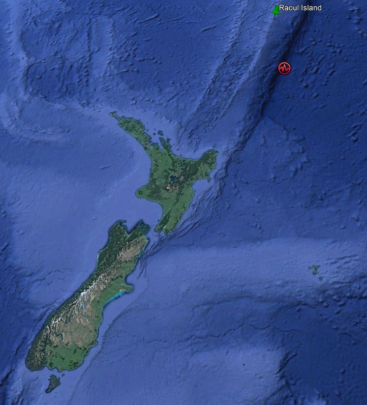
Location of the M7.4 earthquake
Why was the earthquake called ‘weak’ when so many people felt it? This is due to its distance from New Zealand 700km north-east of Gisborne. Our shaking intensity scale gives the impact of an earthquake on people living on the earth's surface, instead of magnitude which is the energy released during an earthquake, and so it can be more useful as an indicator of the earthquake's significance to the community. This earthquake was felt widely along the East Coast of New Zealand as a large, shallow earthquake like this produces strong low-frequency surface waves which should travel nicely through the crust along the plate boundary.
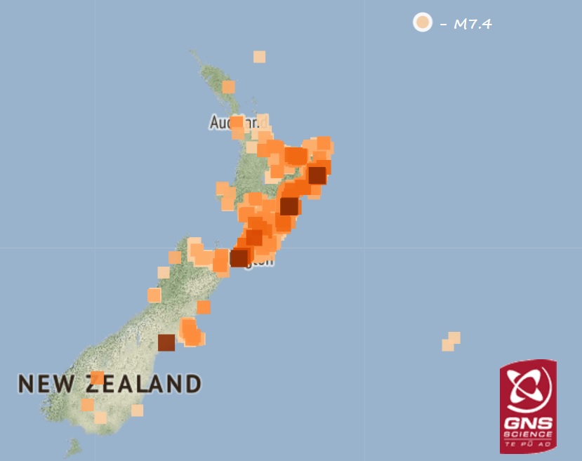
Distribution of felt reports received from the M7.4 earthquake
So, how does GeoNet monitor tsunami? GeoNet has seismic instruments throughout the country that enable us to locate and measure the size of local offshore quakes that could potentially generate a tsunami. We also get a data from tsunami tide gauges around the New Zealand coast, these instruments measure the sea surface height near the coast. This information is supplemented by a growing network of deep ocean tsunami buoys in the Pacific that measure the sea surface height in deep water. The data from these instruments arrives at our National Geohazards Monitoring Centre (NGMC) in real time where our specialists can view it 24/7. We also receive earthquake alerts and data from other monitoring agencies around the Pacific.
What do we monitor? With Geonet’s on-land seismic network we are looking to identify local offshore quakes that are large enough and shallow enough to have caused the sea floor to deform. This will displace a large body of water which initiates a tsunami. Analysis of the seismic waves allows our seismologists to estimate the size and location of the earthquake which allows warnings to be issued by Civil Defence agencies. We also monitor the tide gauges around New Zealand and the offshore deep-water gauges to detect tsunamis caused by earthquakes or by other sources, such as submarine landslides or volcanoes.
What does the network of coastal tsunami gauges tell us? During a tsunami the coastal tsunami gauges can tell us about the amplitude (size) and arrival time of the tsunami wave at that location. Tsunamis can continue to resonate within harbours for hours to days, so we can use the data from each gauge to monitor how the tsunami is decaying in amplitude over time at that location. We can also use the gauge information to learn more about the source that created the tsunami to help better understand tsunamis and their causes.
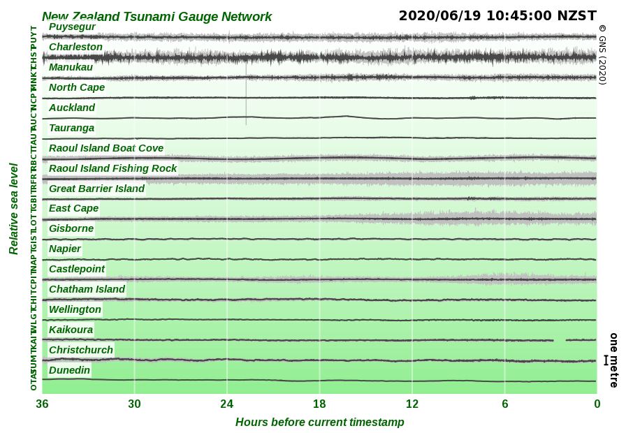
Tsunami Gauge Chart (De-tided )
What does GeoNet do when a large offshore quake may have generated a tsunami? If the earthquake is local (within one hours travel time), then we can use software to quickly estimate which areas of New Zealand may need to be evacuated, this information is passed on to the National Emergency Management Agency (NEMA). For regional (1-3 hours travel time) and distant sources (more than 3 hours travel time), we have a pre-calculated set of tsunami threat maps ready to go for the most likely earthquakes to occur at these distances. We then compare the earthquake’s location and magnitude with these pre-calculated tsunami threat maps to see if it is similar to one of the pre-calculated scenarios. This information is then passed to NEMA to provide them with an initial assessment of the potential threat to NZ from the tsunami.
What is the Tsunami Expert Panel? The Tsunami Expert Panel (TEP) consists of tsunami experts from a variety of organisations across New Zealand and is activated as soon as an earthquake has been identified as having the potential to generate a tsunami that could be hazardous to New Zealand. The panel examines the data available from Geonet and our international partners to refine the threat maps. The expert panel continues to meet regularly during a tsunami event to update information using the latest available data and models, and to provide other advice to NEMA as needed during the event.
How much time do NZ coastal communities have if a tsunami is generated somewhere in the Pacific? For an earthquake just off the coast of New Zealand the travel time to New Zealand would be a matter of minutes and there won’t be time for an official warning. It is important to recognise the natural warning signs and act quickly. In the case of these events, if you feel long or strong shaking, move immediately to the nearest high ground, out of all tsunami evacuation zones, or as far inland as possible. For earthquakes on the other side of the Pacific the tsunami could take up to about 16 hours to reach New Zealand, depending on exactly where it is.
Want more info?
For information on getting tsunami ready the National Emergency Management Agency (NEMA) have a great website with information on what to do before, during and after an tsunami. Your local Civil Defence Group has tsunami evacuation zone maps and regional advice.
Attributable to: Dr David Burbidge and Dr William Power
Media enquiries: media@gns.cri.nz or 021 574 541