
Deep earthquakes under the North Island and their shaking (intensity?)
On 12 January 2022 over 38,800 people reported feeling an earthquake in central New Zealand; many of these reports were far from the quake itself. We explore the science of deeper earthquakes in the North Island, and how we describe shaking intensity.
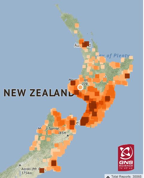
Felt Reports received from the M5.8 Taranaki earthquake
Why is shaking different from deep quakes?
We often get many felt reports from people located some distance from a deep earthquake and very few around the actual epicentre. People often ask, ‘how does that happen’? This M5.8 on Wednesday 12th January 2022, is a good example to explore. The quake was 25 km east of Stratford. A large number of felt reports came from the east and south of the North island, with only a few in the central plateau and further north. This distribution of felt reports is due to the earthquake's depth (nearly 190 km below the surface), location, and ‘what’s under our feet’.
Under our feet:
The North Island sits on the Australian Plate. Typically, deep earthquakes occur in the Pacific Plate, which is subducting or diving under the North Island. The 'slab' of subducting rock in the upper portion of the Pacific Plate is rigid while the surrounding rock is much softer - a mixture of rigid and molten rock. Around the central plateau where we see some of our volcanoes, like Ruapehu, as you may expect there is more molten rock.
The rigid rock of the subducting Pacific Plate is better at transmitting earthquake waves than the softer, semi-molten rock. In fact, molten rock ‘dampens’ the energy from deeper earthquake and helps to explain why the shaking is felt less near the epicentre when earthquakes occur in that area.
When an earthquake happens in or near this slab of subducting plate, most of the quake’s energy travels up and along the slab to the surface - closer to the East and South of the North Island – resulting in the shaking from the earthquake being felt more widely across those areas.
Another great recent example of this phenomenon was the M5.9 earthquake 30 km south-west of Taumarunui, October 2021.
Shaking Intensity – why did we call it Light?
We describe the size of an earthquake using magnitude, which is the size of the earthquake as determined by the data recorded by our seismometers. This is independent of whether anyone feels the earthquake or how strongly they feel it. However, the way that the energy released in an earthquake is felt at the surface is affected by a number of things, including size and, as we just explained what is ‘under our feet’. This is where intensity comes in.
Intensity of shaking from an earthquake is a descriptive measure about the perceived shaking on the surface of the earth, i.e. how strongly people feel the shaking regardless of the magnitude of the earthquake. In New Zealand, where earthquakes occur from near the surface right down to depths of over 600 km, intensity is a very helpful indicator of the shaking that people and infrastructure may have experienced. It’s often used to infer possible effects of the earthquake on people and their environment.
The New Zealand Modified Mercalli Intensity scale grades the effects of earthquakes into twelve steps. The lower numbers of the intensity scale generally cover the way the earthquake is felt by people, and the higher numbers of the scale are based on observed structural damage.
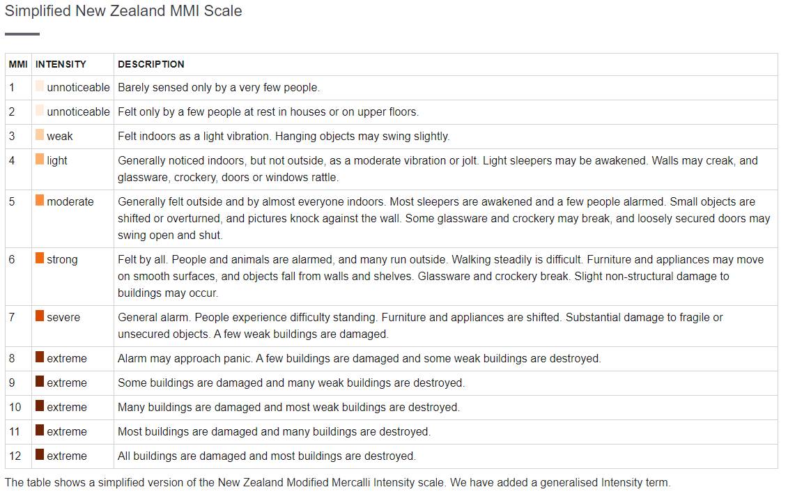
Simplified New Zealand MMI Scale
The predicted shaking intensity for an earthquake on the GeoNet website is estimated from the shaking recorded by seismic instruments, earthquake magnitude, depth, and proximity to population centres. It is estimated for a region close to the epicentre.
This means for a deeper earthquake such as this one where shaking is not felt as closely to the epicentre, this estimation may not reflect everyone’s experience.
Seismic instruments only measure the shaking at the specific spot they’re located. There are many factors that influence how strongly people will perceive shaking. Things like the type of earthquake and its location, local soil conditions, underlying geologic structures, type of building you’re in, etc. all change how much shaking is actually felt or recorded at a given location. So, shaking intensity felt by different people or estimated from a seismic instrument can vary significantly.
Want to tell us your thoughts on earthquake shaking information after an earthquake?
Our researchers are currently working on ways of delivering earthquake shaking information after a large earthquake. These shaking maps will cover the entire country instead of providing data only at the locations of the sensor or the felt reports. This means that you will be able to look for the shaking at any given point in the country. Interactive maps will also be made available where users can zoom in and out and turn on different type of information.
You can help them by completing a short survey, and you can read more about the project here.

Drop, Cover and Hold
And if you feel a Long or Strong earthquake, or receive an emergency mobile alert for a tsunami, Get Gone to higher ground, or as far inland as possible immediately. The National Emergency Management Agency (NEMA) have a great website with information on what to do before, during and after an earthquake. The Earthquake Commission (EQC) also have helpful information on how to get your home, apartment, or rental prepared for a natural disaster.
As always, the GeoNet project and our monitoring capability would not be possible without the support of our partners EQC, LINZ, MBIE, and NEMA.
Attributable to: Elizabeth Abbott, John Ristau GNS Geohazards Duty Seismologists
Media enquiries: media@gns.cri.nz or 021 574 541