
Mount Ruapehu - What’s happening under the hood
There’s currently an increase in volcanic unrest occurring at Mt Ruapehu, so this is a good time to check out some background information on this magnificent volcano. It is now almost 15 years since the last eruption in September 2007.
The history of eruptions at Ruapehu
Mt Ruapehu remains one of our most active cone volcanoes. From our catalogue of observed volcanic activity since the 1830s, there are over 600 days of activity at Mt Ruapehu. From the catalogue we have also learnt that small eruptions only affect the summit plateau around the Crater Lake (Te Wai ā-moe), with larger, lahar generating eruptions occurring on average about once every 7 years. Noting averages are not always a great measure as volcanic activity is often clustered into episodes.
The most recent significant eruption was 25 September 2007, this was an explosive eruption, lasting about 7 minutes. During the eruption, explosions spread ash, rocks and water across the summit plateau, and produced lahars in two valleys including one in the Whakapapa ski field.

Ruapehu summit and lahar on Whangaehu Glacier after eruption 2007
Prior to this was a small eruption in October 2006 where the effects were minimal and confined to the lake basin and a similar event in July 2009 that produced a minor flood in the Whangaehu Valley. The most iconic activity at Mt Ruapehu in recent history were the eruptions of 1995-1996 when multiple eruptions through the crater lake occurred. They produced lahars and high ash plumes that deposited ash over a wide area after the lake was removed.
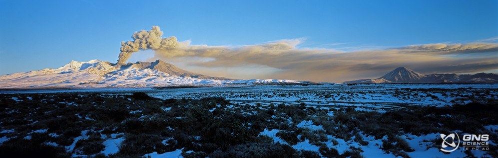
Mount Ruapehu eruption at sunrise 19 June 1995
So, what’s happening at the volcano now?
Current unrest is primarily based on seismic activity, in particular volcanic tremor, this is a semi-continuous type of volcanic earthquake signal made by the movement of hot gases and or fluids within the volcano.
Recently completed analysis of the lake water and gas samples do not indicate significant changes in the geothermal system feeding into the lake. The amount of gas released through the lake has increased from the previous measurements but remains within the typically observed long term trends. The results to date are typical for the beginning of a heating cycle with the exception that tremor values are unusually high.
The crater lake is currently warming, and the lake temperature has now risen to 37 °C. The temperature of the lake typically ranges from ~12 °C to ~45°C, over periods of up to 12 months. These temperature cycles have occurred many times over the last 15 years with no eruptions.
During heating episodes, the lake often changes colour. The lake has now changed to a battleship grey colour caused by the suspended sediments that are stirred up by the steam and gas entering the lake from below. Sulphur slicks are present on the lake surface, these appear as Sulphur forms at the base of Crater Lake and can then get disturbed during a heating phase.
Research on the crater lake eruptive history has shown that the probability of an eruption increases when the lake is significantly warmer or cooler than the average lake temperature range, although eruptions are significantly more frequent when the lake is hot.
How we keep an eye on Ruapehu
GeoNet monitors Ruapehu volcano and its crater lake. The monitoring includes seismic, acoustic, GPS sensors around the volcano, gas flights and sampling of the lake. The temperature and water level of the lake are also monitored by a datalogger at the lake outlet sending regular data to the GeoNet volcano team. You can check out the latest updates via the Volcano Activity Bulletins here.

Aerial view of the Crater Lake during a sampling trip on 31 March 2022
Planning on visiting Mt Ruapehu?
The Department of Conservation have put in place a 2km exclusion zone from the centre of Te Wai ā-moe/Crater Lake. For information on access to the Mt Ruapehu area, please visit the Department of Conservation’s website on volcanic risk in Tongariro National Park and follow their Facebook page for further updates. You can read all of our Volcanic Activity Bulletins here.
Although we can’t prevent natural hazards, we can prepare for them – and we should.
The National Emergency Management Agency (NEMA) has a great website with information on what to do before, during and after volcanic activity.
GNS Science have information on preparing and dealing with ash fall.
Attributable to: Brad Scott, Volcano Information Specialist
Media contact: 021 574 541 or media@gns.cri.nz